- Mount Hugh Neave
-
Mount Hugh Neave 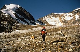
Mount Hugh Neave (center) from Hobson GlacierElevation 2,829 m (9,281 ft) Prominence 800 m (2,625 ft) Location British Columbia, Canada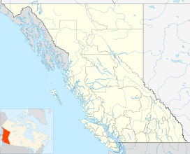

Range Cariboo Mountains Coordinates 52°30′35″N 120°13′44″W / 52.50972°N 120.22889°WCoordinates: 52°30′35″N 120°13′44″W / 52.50972°N 120.22889°W Topo map 93A/9 or PS-WG3 (north half) Geology Type Arete Climbing First ascent No recorded ascents Easiest route East from Hobson Lake Mount Hugh Neave is a mountain in east-central British Columbia, Canada, located between Hobson Lake to the west and Goat Creek to the south. Situated in the Cariboo Mountains of the Columbia Mountains, it is the fourth highest mountain in Wells Gray Provincial Park with an elevation of 2,829 m (9,281 ft).[1]
Contents
Naming
Mount Hugh Neave is named for Hugh Neave (1909-1988) who was a mountaineer, rock climber and backcountry explorer of Wells Gray Park from 1966 to 1987. He was a latecomer among the explorers of Wells Gray Park, but he was drawn by the scenery and the challenge of mountaineering, rather than by the wealth of mining, trapping or guiding. In 1966, he made his first expedition to the Huntley-Buchanan Ridge north of Azure Lake and was a regular visitor to those peaks for the next 20 years.[1]
In 1972, Neave and Peter Cowan of New Zealand attempted to climb Mount Hugh Neave via the Hobson Glacier east of the peak. They reached an elevation of 2,400 m (7,874 ft) on its south side, but ran short of time for an Azure Lake boat rendezvous and had to retreat through the Goat Creek valley. In those years, the boat did not pass twice a day as it does now, so missing an arranged meeting could have meant a long wait for the next boat arrival.[1]
Neave organized three expeditions to Garnet Peak, Wells Gray Park's highest mountain, which were all turned back by severe weather. He blazed the first trail from Azure Lake to Huntley Col and improved it with each trip. Today, it is the only trail from the lakeshore and is maintained by its users. Finally, in 1974 at the age of 65, Neave launched his fourth expedition with Barb Hargreaves and Tor Schmid, and they achieved the first ascent of Garnet Peak. Neave named the mountain for the small garnets he found in rock formations near the summit.[1]
Neave also travelled around the world seeking mountaineering adventures. In 1978 he led a month-long expedition to the Andes of Peru, in 1986 he canoed the Yukon River from Whitehorse to Dawson City, and his last major expedition was a 1987 trek in the Himalayas at age 78. Neave died in 1988 and Mount Hugh Neave was named the following year in recognition of his climbs in northern Wells Gray Park. Later in 1988, members of the Kamloops Mountaineering Club carried his ashes to the top of Garnet Peak.[1]
Access
The Kamloops Mountaineering Club organized two expeditions during the 1990s with the goal of reaching the summit of Mount Hugh Neave. Both flew to Hobson Lake and started the climb from the sandspit about halfway up the lake. They reached the alpine meadows both times after a rigorous bushwhack, but were turned back by severe weather conditions. No other attempts have been made since then. It is possible that Mount Hugh Neave has never been climbed. It is not technically difficult, but the approach through dense forest and undergrowth poses the biggest challenge. Helicopters and float planes require a permit from B.C. Parks to land at Hobson Lake and no other landing sites closer to the mountain are allowed.
On topographical maps, a route up Goat Creek to the base of Mount Hugh Neave appears feasible. The Neave/Cowan expedition of 1972 proved the opposite during their forced retreat to Azure Lake. Neave described Goat Creek in his diary, "It is usually a matter of fighting a recurrent medley of slide alder, devil’s club, scrub growth and a vast jumble of rotting deadfall, eked out by beaver swamps along the valley bottom." His advice to future climbers: "Remember the going will always be tough, daily mileages will be much less than expected, a nose for route finding in poor visibility is essential, and a search and rescue operation will have a minimal chance of success."[2]
References
- ^ a b c d e Neave, Roland (2004). Exploring Wells Gray Park, 5th edition. Wells Gray Tours, Kamloops, BC. ISBN 0-9681932-1-8.
- ^ Neave, Hugh (1974). Two Goats and a Creek, article in Neave, Roland (2004). Exploring Wells Gray Park, 5th edition. Wells Gray Tours, Kamloops, BC. ISBN 0-9681932-1-8.
External links
Categories:- Mountains of British Columbia
- Wells Gray-Clearwater
- Cariboo Mountains


Wikimedia Foundation. 2010.