- Mount Brewer
-
Mount Brewer 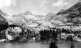
Mount Brewer from East LakeElevation 13,576 ft (4,138 m) [1][2] Prominence 1,168 ft (356 m) [2] Parent peak Table Mountain[2] Listing SPS Emblem peak[3] Location Location Tulare County, California, USA Range Sierra Nevada, Great Western Divide Coordinates 36°42′31″N 118°29′07″W / 36.7085481°N 118.4853741°WCoordinates: 36°42′31″N 118°29′07″W / 36.7085481°N 118.4853741°W[4] Topo map USGS Mount Brewer[2] Climbing First ascent July 2, 1864 by William H. Brewer and Charles F. Hoffmann[5] Easiest route Easy Scramble, class 2[6] Mount Brewer is on the Great Western Divide, a sub-range of the Sierra Nevada in California. It is located in Kings Canyon National Park,[7]
The peak was named for William Henry Brewer who worked on the first California Geological Survey and was the first Chair of Agriculture at Yale University's Sheffield Scientific School. He was chief of the field party that explored the central High Sierra in 1864.[5]
See also
- California 4000 meter peaks
- Thirteener
References
- ^ The NGVD 29 elevation of 13,570 feet was converted using VERTCON to the NAVD 88 elevation of 13,576 feet.
- ^ a b c d "Mount Brewer, California". Peakbagger.com. http://www.peakbagger.com/peak.aspx?pid=2783. Retrieved 2008-12-21.
- ^ "Sierra Peaks Section List". Angeles Chapter, Sierra Club. http://angeles.sierraclub.org/sps/spslist.pdf. Retrieved 2008-12-29.
- ^ "Mount Brewer". Geographic Names Information System, U.S. Geological Survey. http://geonames.usgs.gov/pls/gnispublic/f?p=gnispq:3:::NO::P3_FID:219808. Retrieved 2008-12-21.
- ^ a b Farquhar, Francis P. (1926). Place Names of the High Sierra. San Francisco: Sierra Club. http://www.yosemite.ca.us/library/place_names_of_the_high_sierra/b.html.
- ^ Roper, Steve (1976). The Climber's Guide to the High Sierra. Sierra Club Books. p. 275. ISBN 0-87156-147-6.
- ^ National Park Service (2002-04-20). Sequoia and Kings Canyon National Parks map (Map). http://www.nps.gov/seki/planyourvisit/upload/sekiMap.pdf. Retrieved 2008-12-29.
Categories:- Mountains of Tulare County, California
- Mountains of Kings Canyon National Park
- Tulare County, California geography stubs

Wikimedia Foundation. 2010.