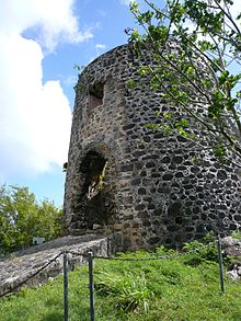
Mount Healthy windmill

Mount Healthy windmill

Mount Healthy windmill is a ruined windmill on the north side of Tortola in the British Virgin Islands. It was formerly used during the plantation era of the Territory to crush sugar cane. After the collapse of the sugar economy in the early nineteenth century the windmill fell into disuse and became a ruin. It crushed cane for the sugar mill and rum distillery in nearby Brewer's Bay.

One of the owners of the mill was Balziel Hodge, son of the notorious Arthur William Hodge.

Today it is a national park.

Gallery

Sources

See also


Wikimedia Foundation. 2010.

Игры ⚽ Нужна курсовая?

Look at other dictionaries:

  • Mount Healthy — may refer to: Places United States Mount Healthy, Indiana Mount Healthy, Ohio Mount Healthy High School Mount Healthy Heights, Ohio British Virgin Islands Mount Healthy windmill, Tortola …   Wikipedia

  • Copper Mine, Virgin Gorda — The ruins at Copper Mine point, Virgin Gorda The Copper Mine on Virgin Gorda, British Virgin Islands is a National Park containing the ruins of an abandoned 19th century copper mine. Copper was first discovered on Virgin Gorda. Local legends also …   Wikipedia

  • Cooper Bay ruin — The ruins at Cooper Bay. Cooper Bay ruin is a ruin in Cooper Bay, on the north side of Tortola in the British Virgin Islands. The ruin dates from the sugar plantation era, and was presumed abandoned during the economic collapse of the British… …   Wikipedia

  • Cooten Bay ruin — The ruins at Cooten Bay. The Cooten Bay ruin is a ruin in Cooten Bay, on the north side of Tortola in the British Virgin Islands. The ruin probably dates from the sugar plantation era, although the fortification of the property with cannon may… …   Wikipedia

  • performing arts — arts or skills that require public performance, as acting, singing, or dancing. [1945 50] * * * ▪ 2009 Introduction Music Classical.       The last vestiges of the Cold War seemed to thaw for a moment on Feb. 26, 2008, when the unfamiliar strains …   Universalium

  • United Kingdom — a kingdom in NW Europe, consisting of Great Britain and Northern Ireland: formerly comprising Great Britain and Ireland 1801 1922. 58,610,182; 94,242 sq. mi. (244,100 sq. km). Cap.: London. Abbr.: U.K. Official name, United Kingdom of Great… …   Universalium

  • Europe, history of — Introduction       history of European peoples and cultures from prehistoric times to the present. Europe is a more ambiguous term than most geographic expressions. Its etymology is doubtful, as is the physical extent of the area it designates.… …   Universalium

  • Barbados — For other uses, see Barbados (disambiguation). Coordinates: 13°10′N 59°33′W / 13.167°N 59.55°W / 13.167; 59.55 …   Wikipedia

  • Swallow, Lincolnshire — Swallow is a small village in Lincolnshire, on the A46 road just northeast of Caistor. The village has a small war memorial. History The name Swallow has been variously written as Sualan ( Domesday Book ), Suawa, Swalwe and Swalewe (all twelfth… …   Wikipedia

  • List of battles 1801–1900 — List of battles: before 601 601 1400 1401 1800 1801 1900 1901 2000 2001 current See also: Battles of the American Civil War 19th century 1801 to 1825* 1801 ** Battle of Aboukir March 20 British Turkish army under Sir Ralph Abernathy defeats… …   Wikipedia

Share the article and excerpts

Direct link
Do a right-click on the link above
and select “Copy Link”