- Mormon Pioneer National Heritage Area
-
Mormon Pioneer National Heritage Area (MPNHA) 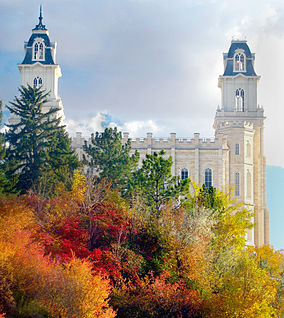
The Mormon Temple in Manti, Utah is one of the most prominent landmarks and symbols of the MPNHALocation Utah, USA Established October, 2006 Governing body National Park Service The Mormon Pioneer National Heritage Area (MPNHA) spans 250 miles (400 km) within central and southern Utah, mostly along a corridor followed by scenic byways U.S. Highway 89 and Utah State Route 24, and the half-loop of Utah State Route 12, which is Utah’s only All-American Road. It was established by the U.S. Congress to commemorate the sacrifices and triumphs of the Mormon pioneers who settled the region and to familiarize the public with the lifeways of the Ute and Paiute Indians who inhabited it before them.[1]
The MPNHA is administered by a decentralized committee drawn from members of the Heritage Highway Alliance, which is composed of artisans, heritage groups, citizens and representatives from the Koosharem Band of Paiutes, and governments of the six counties covered by the area; Garfield, Kane, Piute, Sanpete, Sevier and Wayne. The MPNHA is divided into five districts, according to geographic and historic criteria: Little Denmark, Sevier Valley, the Headwaters, Under the Rim and the Boulder Loop. The largest cities within the area are, in descending order of population, Richfield, Ephraim, Kanab, Manti, Mount Pleasant, Gunnison, and Salina, each having a population of more than 2,000 inhabitants.
The MPNHA has no official connection with The Church of Jesus Christ of Latter-day Saints (LDS Church).
Contents
History
The area which now composes the MPNHA was settled by pioneers in the years following the emigration of Mormons, into the Wasatch Front region of Utah.[2] It was the intent of Brigham Young to establish colonies throughout the Intermountain West from Oregon to the Mexican border, and to create a "Mormon Corridor" from Salt Lake City to the Pacific Ocean.
The Mormon settlers of Central Utah had to contend with hostile Indians,[3] difficult and often nearly impenetrable mountainous terrain and a capricious high desert climate.[4]
The pioneers found themselves at a disadvantage against the Ute, Paiute and Navajo Indians during the Black Hawk War. The natives, who were losing their best foraging and hunting grounds to the pioneers, herded cattle and horses gathered from raids on Mormon towns into the nearby mountains; terrain with which the settlers were mostly unfamiliar. Later, they would exchange the bounty of their raids with outlaw traders for weaponry and ammunition. The farmers and townspeople often found themselves outgunned. In response, they consolidated their settlements into forts, sometimes abandoning whole towns.
The landscape itself was often the most serious hindrance to settlement, as was famously demonstrated by the San Juan Expedition of 1879. Charged by church leaders with establishing a colony in southeastern Utah, and faced with a circuitous wagon route that would have taken it hundreds of miles around the slickrock wilderness south of Escalante, Utah, the expedition was inspired to create a more direct route across the barren stone bluffs in its path. Members had to blast and chisel open a route through a crevice, known as "Hole-in-the-Rock" in the sandstone cliff above the river, lower their 83 wagons by rope down the steep grade using teams of horses, oxen and men and then float the wagons across the river on rafts. Further obstacles on the far side of the San Juan River also hindered their progress. The journey from Escalante to what is now the town of Bluff, Utah was expected to take six weeks but ended up costing the determined colonists about six months.[5]
Beyond the sometimes hostile natives and natural impediments to travel, the pioneers had to contend with the harsh and unpredictable climate and short growing season of the High Plateau Region, which made ranching and farming difficult and often only marginally profitable. Some settlements were literally washed away by floods while others were killed off by a lack of irrigation water.[6]
Despite these adversities, the Mormons succeeded in establishing permanent settlements in the region which still contains thousands of examples of historic pioneer buildings. The most notable architectural achievement of the settlers was the Manti Utah Temple which was constructed in the last quarter of the nineteenth century from oolite limestone quarried nearby. The temple contains two 95 foot unsupported wooden spiral staircases.
Twenty minutes north of Manti, the entire town of Spring City has been listed as a historic district on the National Register of Historic Places. It contains many examples of oolite, brick and adobe homes, mostly constructed by the Scandinavians converts who settled the area.
Panguitch, in the Headwater District, is also listed on the National Register of Historic Places.
Heritage area establishment
Utah Senator Bob Bennett introduced legislation to establish the MPNHA in April 2003 for the purpose, as he put it, of preserving “the rich heritage and tremendous achievements of the Mormon Pioneers.” His bill was passed by the U.S. Senate in July 2006 and signed into law by President George W. Bush in October of the same year.
According to the mission statement of its summary plan, the MPNHA “preserves, interprets, promotes, and enhances Utah’s pioneer heritage.” Its members “work to increase tourism, encourage economic development, revitalize communities, provide heritage educational opportunities, and improve the quality of life” within the districts of the MPNHA.
The mission of the heritage area was formulated with reference to three central themes: the interaction of people with the landscape, the interaction of people with each other and the interaction of people with the institutions they created.[1]
Since its management plan was approved by the U.S. Park Service in 2009, the MPNHA has helped fund several interpretive and revitalization projects within its boundaries, including the renovation of the Casino Theatre in Gunnison, the restoration of Carnegie libraries in Ephraim and Mount Pleasant the construction of an arena in Mount Pleasant as the initial stage of a heritage park, the renovation of Fairview's historic dance hall, the establishment of interpretive centers at Escalante, Big Rock Candy Mountain and Manti, the construction of a historic plaza at Snow College in Ephraim and the creation of a Quilt Walk Monument in Panguitch.
See also
- Anasazi State Park Museum
- Escalante Petrified Forest State Park
- Kodachrome Basin State Park
- National Heritage Area
- Palisade State Park
- Piute State Park
References
- ^ a b MPNHA Summary
- ^ Utah History Encyclopedia. Media.utah.edu. Retrieved on 2011-03-21.
- ^ Utah History Encyclopedia. Media.utah.edu. Retrieved on 2011-03-21.
- ^ Utah History Encyclopedia. Media.utah.edu. Retrieved on 2011-03-21.
- ^ Utah History Encyclopedia. Media.utah.edu. Retrieved on 2011-03-21.
- ^ Utah History Encyclopedia. Media.utah.edu. Retrieved on 2011-03-21.
External links
Categories:- Geography of Garfield County, Utah
- Geography of Kane County, Utah
- National Heritage Areas of the United States
- Geography of Piute County, Utah
- Geography of Sanpete County, Utah
- Geography of Sevier County, Utah
- Geography of Wayne County, Utah

Wikimedia Foundation. 2010.