- Utah State Route 12
Infobox road
state=UT
type=SR
route=12
alternate_name=A Journey Through Time Scenic Byway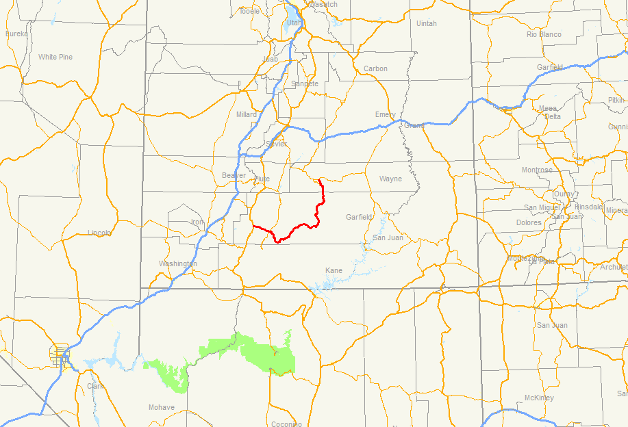
section=107
maint=UDOT
length_mi=122.863
length_round=3
length_ref=Utah Department of Transportation , [http://www.udot.utah.gov/main/f?p=100:pg:2814615533739116:::1:T,V:814, Highway Reference Information] : [http://www.udot.utah.gov/main/uconowner.gf?n=7229601114947628 SR-12] , updated2008-05-01 , accessed July 2008]
established=1914 as a state highway; 1920s as SR-12
direction_a=West
terminus_a=jct|state=UT|US|89 near Panguitch
junction=jct|state=UT|SR|63 nearBryce Canyon
Hole in the Rock Rd. near Escalante
direction_b=East
terminus_b=jct|state=UT|SR|24 near Torrey
previous_type=SR
previous_route=10
next_type=SR
next_route=13State Route 12 or Scenic Byway 12 (SR-12), also known as "Highway 12 — A Journey Through Time Scenic Byway", is a state highway designated an
All-American Road located in Garfield County and Wayne County,Utah ,USA .Route description
Proceeding west to east for 122 miles (nearly 200 km), the highway starts south of Panguitch at an intersection with US-89, crosses part of
Dixie National Forest andBryce Canyon National Park , continues through the small towns of Tropic, Cannonville, and Henrieville. It crosses various parts ofGrand Staircase-Escalante National Monument (GS-ENM), continues northeast through Escalante and over theEscalante River , then north through more of GS-ENM, Boulder, theAquarius Plateau , Grover, ending in Torrey at an intersection with SR-24, five miles west ofCapitol Reef National Park . The 30 mile long portion of the highway that ascends and descends Boulder Mountain on the Aquarius Plateau is known as Boulder Mountain Highway.Traffic volume
The Average Daily Traffic (AADT) on SR-12 is at its greatest at its western junction with US-89, where the count for 2005 was 2,430. At its other end, at the junction with SR-24, the traffic bottoms out at 435. [ [http://www.dot.utah.gov/download.php/tid=1617/2005TrafficOnUtahHighways.pdf UDOT Traffic Counts, page 6] ]
History
The road from Bryce Canyon Junction to Tropic was added to the state highway system in 1914, and in 1923 a branch from Tropic Junction to
Bryce Canyon was built as aforest road .Utah Department of Transportation , [http://www.udot.utah.gov/main/f?p=100:pg:5285268476414239680:::1:T,V:1348, Highway Resolutions] : PDFlink|1= [http://www.udot.utah.gov/main/uconowner.gf?n=200609121823081 Route 12] |2=9.71 MB, updated September 2007, accessed May 2008] The State Road Commission numbered the route to Bryce Canyon SR-12 in the 1920s, [State Road Commission, [http://www.nps.gov/archive/pisp/adhi/fig23a.jpgUtah State Trunk Lines] , 1923] and in 1927 the state legislature assigned it to both branches, to Bryce Canyon and Tropic, [cite UTSR|year=1927|quote=12. From Hillsdale, about 7 miles south of Panguitch, southeasterly via Tropic Junction; to Bryce Canyon; also from Tropic Junction to Tropic.] but split off the branch to Tropic as State Route 54 in 1931. That same year, a new State Route 120 was created, continuing the road from Tropic to Henrieville, [cite UTSR|year=1931|quote=(54) From Tropic junction on route 12 to Tropic." "(120) From Tropic southerly via Cannonville to Henrieville.] and in 1935 it became part of SR-54. [cite UTSR|year=1935] Another road was also added to the state highway system in 1914, connecting SR-22 at Widtsoe with Escalante,Utah Department of Transportation , [http://www.udot.utah.gov/download.php/tid=1348/StateRouteHistory.pdf State Route History] , accessed July 2007] and it was numbered State Route 23 in 1927. [cite UTSR|year=1927|quote=23. From Widtsoe easterly to Escalante.] An extension took SR-23 northeast to Boulder in 1941, [cite UTSR|year=1941|chapter=34] and in 1947 SR-54 absorbed SR-23, with the Widtsoe-Escalante road dropped in favor of Henrieville-Escalante. [cite UTSR|year=1947|chapter=49|quote=Route 54. From Tropic Junction on route 12 via Tropic, Cannonville, Henrieville, and Escalante to Boulder.] State Route 117, running southeast from SR-24 near Teasdale to Grover, became a state highway in 1931, [cite UTSR|year=1931|quote=(117) From junction with route 24 east of Bicknell, southerly via Teasdale to Grover.] and was extended south to Boulder in 1957, becoming part of SR-54 in 1966. [Utah Department of Transportation , [http://www.udot.utah.gov/main/f?p=100:pg:5285268476414239680:::1:T,V:1348, Highway Resolutions] : PDFlink|1= [http://www.udot.utah.gov/main/uconowner.gf?n=200609181317241 Route 117] |2=1.55 MB, updated November 2007, accessed May 2008] In 1969, SR-54 became part of SR-12, but most of former SR-117 was dropped, leaving SR-12 to stretch from Bryce Canyon Junction to the north limit of Boulder (at theDixie National Forest boundary), with a short spur to Bryce Canyon. This spur became a new SR-63 in 1975, and in 1985 the route was extended back north from Boulder to SR-24, using a different route than old SR-117 north of Grover.Major intersections
ee also
*
Paunsaugunt Plateau Gallery
References
External links
* [http://www.byways.org/browse/byways/2020/travel.html Map and more] from the DOT's American Byways website
* [http://www.utah.com/byways/highway_12.htm State of Utah's website] for the highway
Wikimedia Foundation. 2010.