- Utah State Route 24
Infobox road
state=UT
type=SR
route=24
alternate_name=Capitol Reef Scenic Byway
section=108
maint=UDOT 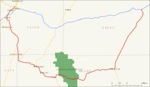
length_mi=163.294
length_round=3
length_ref= [http://www.dot.utah.gov/main/uconowner.gf?n=7190115996876270 UDOT Highway Reference, SR-24] ]
established=1910 as a state highway; 1927 as SR-24
direction_a=West
terminus_a=jct|state=UT|US|50 in Salina
junction=jct|state=UT|SR|118 in Sigurd
jct|state=UT|SR|62 at Plateau Junction
jct|state=UT|SR|25 near Fish Lake
jct|state=UT|SR|72 near Loa
jct|state=UT|SR|12 in Torrey
jct|state=UT|SR|95 in Hanksville
direction_b=East
terminus_b=jct|state=UT|I|70|US|50 near Green River
previous_type=SR
previous_route=23
next_type=SR
next_route=25State Route 24 (SR-24) is a
state highway in south centralUtah which runs south from Salina through Sevier County then east through Wayne County and north east through Emery County. A portion of the highway has been designated the "Capitol Reef Scenic Byway" as part of theUtah Scenic Byways program.Route description
The highway starts at US-50 near Salina and ends at I-70 near Green River, taking a 160 mile scenic route between the Fishlake and
Dixie National Forest s then throughCapitol Reef National Park , along the eastern side of theSan Rafael Reef passingGoblin Valley State Park and meeting I-70 again near Green River. Along the way it passes through the small towns of Loa, Lyman, Bicknell, Torrey and Hanksville. The highway traverses an ever drier series of scenic areas starting in the west with the high, forested, mountains of Fishlake National Forest then the red cliffs of the Bicknell, Torrey area before winding through the spectacularWaterpocket Fold in Capitol Reef N.P. to the much drier "moonscape" near Hanksville. TheMars Society established theMars Desert Research Station just outside of Hanksville, due to its Mars-like terrain. The north easterly section past the San Rafael Reef is open desert with distant views of the Henry andLa Sal Mountains .Traffic volume
The Average Daily Traffic (AADT) for SR-24 is at its greatest between Salina and Sigurd, where it varies between 3,085 down to 1,500 at the Junction with SR-118. Past that point, the volume of traffic varies greatly, reaching peaks where the highway coincides with the main streets in the several towns through which it passes. In Loa, the AADT reaches 2,080, in Torrey, it peaks at 1,230. Then the traffic dies down to 295 by the time SR-24 arrives back at
I-70 . [ [http://www.dot.utah.gov/download.php/tid=1617/2005TrafficOnUtahHighways.pdf "2005 Traffic On Utah Highways," page 12. - Dept. of Transportation @ Utah.gov] ]History
The road from SR-11 (US-89) at Sigurd southeast and east to Hanksville became a state highway in 1910 (Wayne County) and 1912 (Piute and Sevier Counties).
Utah Department of Transportation , [http://www.udot.utah.gov/main/f?p=100:pg:5285268476414239680:::1:T,V:1348, Highway Resolutions] : PDFlink|1= [http://www.udot.utah.gov/main/uconowner.gf?n=200609131019101 Route 24] |2=17.9 MB, updated September 2007, accessed May 2008] The number was assigned in 1927 by the state legislature, [cite UTSR law|year=1927|quote=24. From Sigurd southeasterly via Plateau Junction, Loa and Fruita to Hanksville.] and in 1935 it was extended northeast from Hanksville to SR-8 (now US-6) near Green River. [cite UTSR law|year=1935|quote=Route 24. From Sigurd southeasterly via Plateau Junction, Loa and Fruita to Hanksville, thence northeasterly to Green River on route 8.] A realignment in 1961 bypassed Capitol Reef Road between Fruita and Caineville; as part of the construction of I-70, the east end was moved west to that highway's exit 149 in 1964. SR-24 was extended north from its west end over former SR-11 (US-89) to SR-28 (now US-89) in 1969, and cut back slightly to its current end at US-50 in the 1977 renumbering. (The 1969 extension was signed as part of US-89 until 1992, soon after I-70 was completed.Utah Department of Transportation , [http://www.udot.utah.gov/main/f?p=100:pg:5285268476414239680:::1:T,V:1348, Highway Resolutions] : PDFlink|1= [http://www.udot.utah.gov/main/uconowner.gf?n=200609181040151 Route 70] |2=17.4 MB, updated November 2007, accessed May 2008] )Major intersections
Jctint
state=UT
county=Sevier
cspan=6
location=Salina
lspan=1
type=
mile=0.000
road=jct|state=UT|US|50|name1=Main Street|city1=Scipio
notes=Western terminusJctint
state=UT
location=Aurora
lspan=1
type=
mile=5.301
road=jct|state=UT|SR|260|dir1=north
notes=Jctint
state=UT
location=Sigurd
lspan=2
type=
mile=7.705
road=jct|state=UT|SR|259|I|70|to2=yes|dir1=north
notes=Jctint
type=
mile=8.165
road=jct|state=UT|SR|118|dir1=south|city1=Richfield
notes=Jctint
state=UT
location=Glenwood
lspan=1
type=
mile=16.006
road=jct|state=UT|SR|119|dir1=west|city1=Richfield
notes=Jctint
state=UT
location=Plateau Junction
lspan=1
type=
mile=32.310
road=jct|state=UT|SR|62|dir1=south|city1=Junction
notes=Jctint
state=UT
county=Piute
cspan=1
location=Fish Lake
lspan=1
type=
mile=39.094
road=jct|state=UT|SR|25|dir1=north
notes=Jctint
state=UT
county=Wayne
cspan=3
location=Loa
lspan=1
type=
mile=51.575
road=jct|state=UT|SR|72|I|70|to2=yes|dir1=north
notes=Jctint
state=UT
location=Torrey
lspan=1
type=
mile=69.526
road=jct|state=UT|SR|12|dir1=south|city1=Escalante
notes=Jctint
state=UT
location=Hanksville
lspan=1
type=
mile=116.484
road=jct|state=UT|SR|95|dir1=south|city1=Blanding
notes=Jctint
state=UT
county=Emery
cspan=2
location=Green River
lspan=2
type=
mile=159.811-160.234
road=jct|state=UT|I|70|US|50|city1=Richfield|city2=Green River
notes=Jctint
type=
mile=160.294
road=Four Corners Mine Road
notes=Eastern terminusReferences

Wikimedia Foundation. 2010.