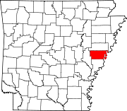
- Monroe, Arkansas
-
Monroe, Arkansas — Unincorporated community — Coordinates: 34°44′05″N 91°06′16″W / 34.73472°N 91.10444°WCoordinates: 34°44′05″N 91°06′16″W / 34.73472°N 91.10444°W Country United States State Arkansas Counties Lee and Monroe Elevation 187 ft (57 m) Time zone Central (CST) (UTC-6) - Summer (DST) CDT (UTC-5) ZIP code 72108 Area code(s) 870 GNIS feature ID 58204[1] Monroe is an unincorporated community in Lee and Monroe counties, Arkansas, United States. Monroe is located at the junction of U.S. Route 79 and Arkansas Highway 39 12 miles (19 km) east-northeast of Clarendon. Monroe has a post office with ZIP code 72108.[2]
References
Municipalities and communities of Lee County, Arkansas County seat: Marianna City Towns Unincorporated
communitiesBrickeys | Monroe‡
Footnotes ‡This populated place also has portions in an adjacent county or counties
Municipalities and communities of Monroe County, Arkansas County seat: Clarendon Cities Towns Unincorporated
communitiesBlackton | Cross Roads | Monroe‡
Footnotes ‡This populated place also has portions in an adjacent county or counties
Categories:- Populated places in Lee County, Arkansas
- Populated places in Monroe County, Arkansas
- Unincorporated communities in Arkansas
- Arkansas geography stubs
Wikimedia Foundation. 2010.


