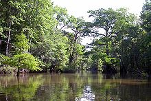
- Mobile-Tensaw River Delta
-
The Mobile-Tensaw River Delta is the largest river delta and wetland in Alabama. It encompasses approximately 260,000 acres (110,000 ha) in a 40 by 10-mile (16 km) area and is the second largest delta in the United States.[1]
The delta is formed by the confluence of the Tombigbee and Alabama rivers, encompasses the converging Coosa and Black Warrior rivers, and is southerly-bound by the Causeway as it ultimately opens into the head of Mobile Bay through Mobile, Tensaw, Apalachee, and Blakeley rivers.[2] It is contained within sections of Baldwin, Clarke, Mobile, Monroe, and Washington counties.[3]
Contents
Environment and Ecology
The delta is ecologically important and includes a wide variety of habitats, including Mesic flood plains, cypress-gum swamps, tidal brackish water marshes, bottomland forests and submersed grassbeds.[4] It is home to some of the most diverse wildlife in Alabama including 126 species of fish, 46 mammals, 69 reptiles, 30 amphibians[5] and at least 300 species of bird, including more than 110 which nest in the region.[6]
Natural history
The delta lies in a river valley which began forming several million years ago. Many separate inland streams joined as they flowed southward across land which was once covered by the Gulf of Mexico. By the end of the last major ice age (approximately 18,000 years ago), when the sea level was much lower and Alabama's coastline was about 60 miles (97 km) south of its present location, the waterways of the delta valley extended much farther than their current-day southern termination at the head of Mobile Bay. As the ice age ended and global temperatures increased, sea levels began to rise again to their present-day level.[7]
History
Humans inhabited the delta region at least as far back as 5,000 years ago.
During the 14th century, Indians of the Mississippian period built earthen mounds along Bottle Creek and the Tensaw River. In time, other peoples moved into the area, including the Taensas, the Creeks, and the Choctaws.
In the 16th century the area was visited by Spanish forces and was again visited in the early 18th century by the French, at which time early-Mobile was first settled.
The delta was also the site of the Fort Mims massacre which occurred in the early 19th century, as well as the last important battle of the American Civil War, which took place at the fortified town of Blakeley located on the rim of the delta.
In the mid-1920s, the Causeway was built across the lowest part of the delta, connecting the western and eastern shores of Mobile Bay. Later, I-65, I-10 and a railway line were constructed to span different parts of the area.[8]
The delta was designated a National Natural Landmark in May 1974.[9]
Recreation
Boating and fishing are popular in the Mobile Delta. Boat ramps and water access points are abundant throughout the area.[10] The Bartram Canoe Trail provides a system of waterways by which boaters may explore the delta. The area is known for its excellent bird watching.[11] Hunting is also a common pastime.
References
- ^ Dauphin Island Sea Lab
- ^ South Alabama Regional Planning Commission
- ^ Encyclopedia of Alabama
- ^ South Alabama Regional Planning Commission
- ^ Encyclopedia of Alabama
- ^ South Alabama Regional Planning Commission
- ^ Encyclopedia of Alabama
- ^ Encyclopedia of Alabama
- ^ NPS NNL Summary
- ^ Outdoor Alabama
- ^ Alabama Coastal Bird Watching
External links
Coordinates: 30°45′15″N 87°56′32″W / 30.754228°N 87.942123°W
Categories:- Protected areas of Baldwin County, Alabama
- Protected areas of Mobile County, Alabama
- National Natural Landmarks in Alabama
- River deltas
- Mobile Bay
Wikimedia Foundation. 2010.

