- Migratory woodland caribou
-
Woodland Caribou 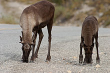
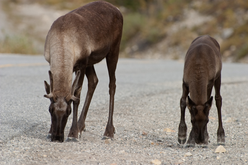
Female and calf in British Columbia Scientific classification Kingdom: Animalia Phylum: Chordata Class: Mammalia Order: Artiodactyla Family: Cervidae Genus: Rangifer Species: R. tarandus Subspecies: R. t. caribou Trinomial name Rangifer tarandus caribou
(Gmelin, 1788)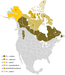
Range of R. t. caribou in dark brown The migratory woodland caribou (Rangifer tarandus caribou), also known as the forest caribou or woodland caribou (not to be confused with woodland reindeer, a term which also includes forest-dwelling Eurasian subspecies), is a subspecies of the caribou. As traditionally defined, it is found in boreal forests of Canada and far northern contiguous United States, ranging from Newfoundland and Labrador west and south to Washington, but some evidence suggests this range actually includes several subspecies.[1][2]
They live in wild herds, including the Leaf herd with 628 000 individuals and the George River herd with 385 000 individuals. The caribou generally travel upwards of 2000 km annually and live in an area of about 1 000 000 square kilometres. Some individuals have been observed traveling 6000 km in a single year.
The caribou population varies considerably, for unknown reasons, and their numbers have apparently peaked in the later decades of each of the 18th, 19th and 20th centuries. The most recent decline at the turn of the 20th century caused much hardship for the Inuit and Cree communities of Nunavik, Quebec, who hunt them for subsistence. By 1950, as few as 5000 caribou remained in northern Quebec and Labrador.
The George River herd, south of Ungava Bay, whose numbers reached about 800 000 towards 1993, had about 384 000 individuals in 2001. The Leaf herd in the west, near the coast of Hudson Bay, has grown from 270 000 individuals in 1991 to 628 000 in 2001. Inuit, Cree and southern sport hunters kill about 30 000 caribou each year in northern Québec.
A much smaller population of migratory woodland caribou, perhaps numbering about 20 000, is found in northern Ontario, on the coastal plains south of Hudson Bay.
Contents
Taxonomy
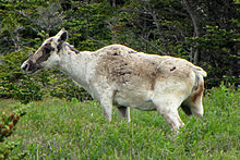 Female in spring, Newfoundland
Based on a review in 1961, R. t. caboti (Labrador Caribou), R. t. osborni (Osborn's Caribou—from British Columbia) and R. t. terraenovae (Newfoundland Caribou) were considered invalid and included in R. t. caribou. Some recent authorities have considered them all valid, even suggesting that they are quite distinct.[1][2] An analysis of mtDNA in 2005 found differences between the caribous from Newfoundland, Labrador, south-western Canada and south-eastern Canada, but maintained all in R. t caribou.[3]
Woodland Caribou in Ontario
Woodland caribou were once found throughout much of Ontario's boreal forest; at the turn of the 20th century they ranged as far south as northern Wisconsin. The last permanent residents were killed in Minnesota in 1962. Despite periodic sightings of individuals south of the border the caribou range has receded approximately 34 km/decade, the manifestation of widespread range collapse and population decline. Although woodland caribou have been protected from sport hunting since 1929, the Committee on the Status of Endangered Wildlife in Canada listed forest-dwelling caribou in Canada as threatened (likely to become endangered if limiting factors are not reversed) in 2000. Woodland caribou may be extinct before the year 2100 if the rate of range loss continues. There is a large herd isolated on the Slate Islands in Lake Superior.
Human-caused landscape disruption is the chief cause of caribou range recession. For example, the conversion of forests by logging may result in greater abundance of other ungulates, like moose, and increased predation by wolves. Linear corridors, such as roads, utility corridors, and trails may improve travel speed and hunting efficiency for predators, improve access for poachers, and hinder caribou movements.
Cutovers from forest harvesting have been identified as the strongest predictor of caribou extirpation. This was not surprising; the northern front of forest harvesting in Ontario closely matches the southern boundary of continuous caribou occupancy and timber harvesting may lead to reduced occurrence of woodland caribou. However, there appears to be a time lag between forest harvest and disappearance of caribou. Research suggests that there is a two decade time lag between disturbance by forest harvest and disappearance of caribou. Forest harvest converts forest stands to early seral stages, which are favoured by moose, which in turn can support a higher wolf population than caribou alone. A higher wolf population may increase predation mortality of caribou. Thus, two decades is likely the time necessary for these faunal changes to take place. This time lag is cause for concern, as there is overlap of forest harvest with the southern boundary of caribou range in Ontario. Caribou in these areas are very likely to vanish in the next 20 years. While patterns of forest harvest show the strongest relationship with caribou extirpation in Ontario, strong correlations among landscape disturbances suggest that no single variable can be unequivocally implicated as key to caribou range recession.
Logging also is a major cause of caribou mortality. Logging the mature boreal forest of northern Minnesota, Wisconsin, Michigan, and Ontario has led to creeping aspen/birch habitat followed by northward moving whitetail deer carrying the parasite Parelaphostrongylus tenuis. The neurological parasite is fatal to caribou and moose.
Woodland caribou persistence in Ontario will likely depend on the availability of large tracts of old growth forest situated at great distances from anthropogenic disturbance. Recent research suggests that forest harvest operations should be buffered from caribou habitat by at least 13 km.
Climate change may have negative potential for woodland caribou as well. Climate change may further alter forest structure to favour moose and white-tailed deer, which may carry the parasite Parelaphostrongylus tenuis; lethal to caribou but not harmful to deer. In addition, increased episodes of freezing rain in the winter may make it difficult for caribou to dig through the snow to reach their primary food source, lichens. The effects of climate change on woodland caribou have not been studied.
Caribou drownings at Calcaire (Limestone) Falls in 1984
In late September 1984, about 115 km south of the northern village of Kuujjuaq, Québec, about 10 000 caribou (appr. 2% of the George River herd) drowned while crossing the Caniapiscau River, immediately above the Calcaire (Limestone) Falls.[4] The Caniapiscau River confluences with the Larch River downstream from Calcaire (Limestone) Falls to create the Koksoak River that flows into southern Ungava Bay. Although the caribou regularly criss-cross northern rivers and lakes and can swim 10 km at a stretch, northern rivers and lakes often claim lives during their annual migrations. At the time of the accident, observers raised questions about Hydro-Quebec's management of the newly built reservoir on the headwaters of the Caniapiscau River,[5] some 450 km upstream, and focused their attention on decisions made in the days following the exceptionally heavy rains in September 1984. The Caniapiscau Reservoir is part of the La Grande hydroelectric complex in Northern Quebec. The waters of the upper Caniapiscau River, which flow north, were diverted into the La Grande River of the James Bay watershed to the west.
The dead caribou drifting and beginning to accumulate along the eastern shore line of the Koksoak River were first noted by the residents of Kuujjuaq, but the cause of the deaths was not confirmed until a team of wildlife biologists and technicians from the Newfoundland-Labrador Wildlife Division arrived by helicopter to participate in a joint cooperative effort with the Quebec Recreation, Hunting and Fishing Department to live-capture and radio-collar caribou swimming across the Koksoak River. Kuujjuaq residents, who were familiar with the river, reported seasonal water levels far higher than normally recorded in recent history. Autumn boat stages, shore line cabin sites and tributary beaver lodges were being flooded. While the dead caribou were thought to have drowned, confirmation was not determined until the Newfoundland-Labrador Wildlife Division used the helicopter to trace the increasingly larger accumulations of floating dead caribou back approximately 115 km upstream from Kuujjuaq to the base of Calcaire (Limestone) Falls on the Caniapiscau River. Coves and backwater were choked with the floating carcasses of dead caribou, with accumulations becoming increasingly larger in approaching the base of the Falls.
Subsequent investigation by the Québec Recreation, Hunting and Fishing Department—whose employees had also observed the dead caribou along the Koksoak River on September 30th—attempted to the conclude that a larger number of caribou would have perished had the Caniapiscau Reservoir not yet been built, since the water flow at the falls would have been even greater in the absence of the reservoir. Hydro-Quebec and SEBJ took this position, but Kuujjuaq hunters and others rejected it.[4] Fikret Berkes wrote in 1988 that "the dispute is unlikely ever to be resolved." [4]
In a short but savvy analysis, Quebec’s Indian and Inuit Secretariat (SIGMAI) expressed the opinion that the fast-growing George River herd may have become accustomed to the reduced water flow from 1981 to 1984, during which time the reservoir was being filled. SIGMAI hypothesizes that the caribou may have been surprised as the water flow of the Caniapiscau River was partially restored to its natural state in mid-September 1984, after the filling of reservoir had been completed. The partial release of the headwaters back into the Caniapiscau was necessary because the power stations on the La Grande River could not yet turbine the full water flow. According to Hydro-Québec, any major addition of water to the La Grande River would by necessity have been diverted around the power stations for months, even years, and seriously damage the floodgates which were designed for temporary use during exceptional climatic events.
Thus, SIGMAI chastised the Société d'énergie de la Baie James, a subsidiary of Hydro-Québec, that had just completed the construction of the reservoir, for not having planned to actively manage the restored water flow to the Caniapiscau River in such a way as to protect the caribou herd from exceptional floods caused by heavy rains or rapid spring thaw. This was a rather novel idea at the time, as no Canadian wildlife expert had foreseen anything more than the usual mortality along the rivers of the region (up to 500 deaths every year).
The Quebec game officials did, however, put forward the opinion that a dynamic management of the water levels and flows of the Caniapiscau Reservoir could have avoided the high mortality observed in September 1984, either completely, or at least reduced it to levels observed in recent years. SIGMAI finally recommended that the water levels of the reservoir be lowered by about 0.5 metre for several months of the year to avoid the use of the flood gates during extreme rainfalls when the caribou are migrating in late summer and early fall. Of course, this is largely a moot point today, since virtually no water has been diverted back into the lower Caniapiscau since 1985. Furthermore, a fence was installed to divert the herd from the danger zone near the Calcaire Falls.
In the United States
In the United States the woodland caribou is one of the most critically endangered mammals, with only a few woodland caribou found south of the Canada border each year. In the US there is only one naturally occurring herd of woodland caribou in extreme northern Idaho, eastern Washington, and British Columbia, Canada, of about 40 animals. There is, however, a concerted effort on the part of the North Central Caribou Corporation and the Boundary Waters Canoe Area Wilderness to reintroduce a herd of around 75 animals from the Slate Islands in Lake Superior to northern Minnesota. However, the high incidence of whitetail deer and wolves in the region will likely prove quite problematic.
References
- ^ a b Grubb, Peter (16 November 2005). Wilson, Don E., and Reeder, DeeAnn M., eds. ed. Mammal Species of the World (3rd ed.). Baltimore: Johns Hopkins University Press, 2 vols. (2142 pp.). ISBN 978-0-8018-8221-0. OCLC 62265494. http://www.bucknell.edu/msw3/browse.asp?id=14200328.
- ^ a b Geist, V. (2007). Defining subspecies, invalid taxonomic tools, and the fate of the woodland caribou. The Eleventh North American Caribou Workshop (2006). Rangifer, Special Issue 17: 25-28.
- ^ Cronin, M. A., M. D. Macneil, and J. C. Patton (2005). Variation in Mitochondrial DNA and Microsatellite DNA in Caribou (Rangifer tarandus) in North America. Journal of Mammalogy 86(3): 495–505.
- ^ a b c Berkes, F. 1988. The intrinsic difficulty of predicting impacts: Lessons from the James Bay hydro project. Environmental Impact Assessment Review 8: 201-220.
- ^ Time Magazine Environment: Mass Death at Two River Crossings. Monday, Oct. 15, 1984
- Government of Quebec, Ministère du Loisir, de la Chasse et de la Pêche (Department of Recreation, Fish and Game). 1985. Considérations relatives à la noyade de caribous du fleuve George sur la rivière Caniapiscau (septembre 1984), Quebec City: MLCP, xvi+100p. (+appendices).
- Government of Quebec, Secrétariat des activités gouvernementales en milieu amérindien et inuit (SIGMAI). 1985. Noyade des caribous sur la rivière Caniapiscau des 28 et 29 septembre 1984, Quebec City: SAGMAI, 14p. (+appendices).
- Racey, G.D. and T. Armstrong. 2000. Woodland caribou range occupancy in northwestern Ontario: past and present. Rangifer, Special Issue 12: 173-184.
- Schaefer, J.A. 2003. Long-term range recession and the persistence of caribou in the taiga. Conservation Biology 17(5): 1435-1439.
- Vors, L.S., J.A. Schaefer, B.A. Pond, A.R. Rodgers and B.R. Patterson. 2007. Woodland caribou extirpation and anthropogenic landscape disturbance in Ontario. Journal of Wildlife Management 71(4): 1249-1256.
External links
Categories:


Wikimedia Foundation. 2010.