- Middletown Regional Airport
-
Middletown Regional Airport
Hook Field
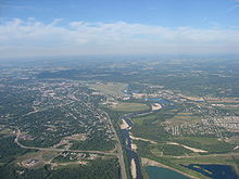
Aerial view of airport from the east IATA: MWO – ICAO: KMWO – FAA LID: MWO Summary Airport type Public Owner City of Middletown Serves Middletown, Ohio Elevation AMSL 650 ft / 198 m Coordinates 39°31′54″N 084°23′47″W / 39.53167°N 84.39639°W Website Runways Direction Length Surface ft m 5/23 6,100 1,859 Asphalt 8/26 3,040 927 Turf Statistics (2007) Aircraft operations 40,050 Based aircraft 84 Source: Federal Aviation Administration[1] Middletown Regional Airport[2], also known as Hook Field,[3][4] (IATA: MWO, ICAO: KMWO, FAA LID: MWO) is a city-owned public-use airport located two nautical miles (3.7 km) north of the central business district of Middletown, a city in Butler County, Ohio, United States.[1] The airport was renamed in October 2008;[4] it was previously known as Hook Field Municipal Airport.
In late August 2008 the airport gained some national prominence when the Republican vice presidential nominee Sarah Palin flew into Hook to later attend a Dayton campaign rally where she was announced as Senator John McCain's running mate.[5]
Facilities and aircraft
Middletown Regional Airport covers an area of 550 acres (220 ha) at an elevation of 650 feet (198 m) above mean sea level. It has two runways: 5/23 is 6,100 by 100 feet (1,859 x 30 m) with an asphalt pavement; 8/26 is 3,040 by 297 feet (927 x 91 m) with a turf surface.[1] It has the longest runway of any non-towered airport in southwest Ohio.[citation needed]
For the 12-month period ending October 1, 2007, the airport had 40,050 aircraft operations, an average of 109 per day: 91% general aviation, 9% air taxi, and <% military. At that time there were 84 aircraft based at this airport: 95% single-engine, 1% multi-engine, 2% jet and 1% helicopter.[1]
References
- ^ a b c d FAA Airport Master Record for MWO (Form 5010 PDF). Federal Aviation Administration. Effective 29 July 2010.
- ^ "B&B Aero Services, Middletown Regional Airport". http://www.bbaero.com/. Retrieved 16 August 2010.
- ^ "Hook Field Middletown Regional Airport". http://www.hookfield.com/. Retrieved 16 August 2010.
- ^ a b Richter, Ed (October 22, 2008). "Airport renamed Middletown Regional Airport/Hook Field". Middletown Journal. http://www.middletownjournal.com/news/content/oh/story/news/local/2008/10/22/mj102308hookfield.html?cxtype=rss&cxsvc=7&cxcat=16.
- ^ Richter, Ed (September 3, 2008). "Airport operator told to be 'evasive;' Now says Palin was on the early flight". The Oxford Press. http://www.oxfordpress.com/hp/content/oh/story/news/local/2008/09/03/mj090408jetlanding.html.
External links
- B&B Aero Services, the airport's fixed base operator (FBO)
- FAA Terminal Procedures for MWO, effective 20 October 2011
- Resources for this airport:
- AirNav airport information for KMWO
- ASN accident history for MWO
- FlightAware airport information and live flight tracker
- NOAA/NWS latest weather observations
- SkyVector aeronautical chart, Terminal Procedures for KMWO
Categories:- Airports in Ohio
- Buildings and structures in Butler County, Ohio
- Middletown, Ohio
- Transportation in Butler County, Ohio
Wikimedia Foundation. 2010.
