Meta Incognita Peninsula

Meta Incognita Peninsula

Coordinates: 62°45′01″N 068°29′58″W / 62.75028°N 68.49944°W / 62.75028; -68.49944 (Meta Incognita Peninsula)

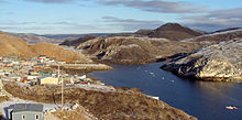
Kimmirut, Meta Incognita Peninsula, 2006

The Meta Incognita Peninsula is located on southern Baffin Island in the Canadian territory of Nunavut. It's bounded by Hudson Strait to the west, and Frobisher Bay to the east. The hamlet of Kimmirut is on the peninsula's northwestern coast.

On his second voyage in July, 1577, Martin Frobisher claimed this area in the name of Queen Elizabeth I of England. The Queen named it Meta Incognita, Latin for "the unknown limits."[1] Frobisher's 1578 voyage was originally planned to establish a settlement here.

Reference

  1. ^ McDermott, James (2001). Martin Frobisher: Elizabethan privateer. New Haven: Yale University Press. p. 190. ISBN 0300083807. http://books.google.com/books?id=YeMcPYIKNYUC&pg=PA190. 


Wikimedia Foundation. 2010.

Игры ⚽ Поможем решить контрольную работу

Look at other dictionaries:

  • Meta Incognita — 62°45′01″N 068°29′58″O / 62.75028, 68.49944 …   Wikipédia en Français

  • Melville Peninsula — Boothia and Melville peninsulas, Nunavut, Canada. Melville Peninsula is a large peninsula in the Canadian Arctic. Since 1999, it has been part of Nunavut. Before that, it was part of the District of Franklin. It s separated from Southampton… …   Wikipedia

  • Cumberland Peninsula — is a peninsula in the southeastern part of Baffin Island, in Nunavut, Canada. It is located between 64°56 and 67°57 north latitude, and 61°56 to 68° west longitude.[1] The Arctic Circle crosses the peninsula, with the Labrador Sea to the… …   Wikipedia

  • Darling Peninsula — The Darling Peninsula is located on the eastern coast of Ellesmere Island, a part of the Qikiqtaaluk Region of the Canadian territory of Nunavut. It stretches eastward into Nares Strait, north of Dobbin Bay. Mount Stevens lies in the center of… …   Wikipedia

  • Cook Peninsula — The Cook Peninsula is located on the eastern coast of Ellesmere Island, a part of the Qikiqtaaluk Region of the Canadian territory of Nunavut. North of Princess Marie Bay, it stretches eastward into Nares Strait. The peninsula is approximately 64 …   Wikipedia

  • Colin Archer Peninsula — The Colin Archer Peninsula is located on the northwestern Devon Island, a part of the Qikiqtaaluk Region of the Canadian territory of Nunavut. It stretches eastward into Baffin Bay. It is named in honor of Colin Archer, naval architect and… …   Wikipedia

  • Collinson Peninsula — The Collinson Peninsula is located on eastern Victoria Island in Canada s Nunavut territory. The Storkenson Peninsula lies to the north, while M Clintock Channel is to the east.[1] It is named after Richard Collinson, officer of the Royal Navy,… …   Wikipedia

  • List of peninsulas — A peninsula is a piece of land that is nearly surrounded by water but connected to mainland via an isthmus. A peninsula can also be a headland, cape, island promontory, bill, point, or spit. [ [http://www.britannica.com/ebi/article 9276348… …   Wikipedia

  • Frobisher Bay — is a relatively large inlet of the Labrador Sea in the southeastern corner of Baffin Island, Nunavut, Canada. Its length is about 230 km and its width varies from about 40 km at its outlet into the Labrador Sea to roughly 20 km towards its inner… …   Wikipedia

  • Iqaluit — Infobox Settlement official name = Iqaluit other name = native name = ᐃᖃᓗᐃᑦ nickname = motto = imagesize = image caption = Aerial view of Iqaluit flag size = image seal size = image shield = shield size = image blank emblem = blank emblem size =… …   Wikipedia

Share the article and excerpts

Direct link
Do a right-click on the link above
and select “Copy Link”