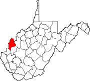
- Mercers Bottom, West Virginia
-
Mercers Bottom, West Virginia — Unincorporated community — Coordinates: 38°38′41″N 82°09′45″W / 38.64472°N 82.1625°WCoordinates: 38°38′41″N 82°09′45″W / 38.64472°N 82.1625°W Country United States State West Virginia County Mason Elevation 584 ft (178 m) Time zone Eastern (EST) (UTC-5) - Summer (DST) EDT (UTC-4) Area code(s) 304 & 681 GNIS feature ID 1552054[1] Mercers Bottom is an unincorporated community in Mason County, West Virginia, United States. Mercers Bottom is located on West Virginia Route 2 13.5 miles (21.7 km) south of Point Pleasant.
References
Municipalities and communities of Mason County, West Virginia City Towns Hartford City | Henderson | Leon | Mason | New Haven
CDPs Apple Grove | Gallipolis Ferry
Unincorporated
communitiesAmbrosia | Arbuckle | Arlee | Ashton | Beech Hill | Capehart | Clifton | Couch | Elmwood | Glenwood | Greer | Grimms Landing | Lakin | Letart | Mercers Bottom | Mount Olive | Sassafras | Southside | Upland | West Columbia | Wyoma
Categories:- Populated places in Mason County, West Virginia
- Unincorporated communities in West Virginia
- Metro Valley geography stubs
Wikimedia Foundation. 2010.


