- Meadow Creek, West Virginia
-
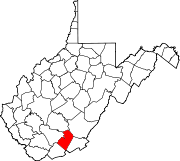
Meadow Creek, West Virginia — Unincorporated community — Coordinates: 37°48′36″N 80°55′23″W / 37.81°N 80.92306°WCoordinates: 37°48′36″N 80°55′23″W / 37.81°N 80.92306°W Country United States State West Virginia County Summers Elevation 1,289 ft (393 m) Time zone Eastern (EST) (UTC-5) - Summer (DST) EDT (UTC-4) Area code(s) 304 & 681 GNIS feature ID 1543056[1] Meadow Creek is an unincorporated community in Summers County, West Virginia, United States. Meadow Creek is located on the New River southwest of Meadow Bridge and north of Hinton.
References
Municipalities and communities of Summers County, West Virginia City Unincorporated
communitiesBallengee‡ | Bargers Springs | Barksdale | Barnettown | Bertha | Beurytown | Brooklin | Brooks | Browning | Buck | Carew | Claypool | Clayton | Crossroads | Crumps Bottom | Ellison | Ellison Ridge | Elton | Farley | Forest Hill | Glenray | Green Sulphur Springs | Griffith Creek | Hill Top | Hilldale | Hix | Indian Mills | Judson | Jumping Branch | Lick Creek | Lockbridge | Lowell | Mandeville | Marie | Meadow Creek | Mountview‡ | Neponset | Nimitz | Pence Springs | Pipestem | Ramp | Riffe | Sandstone | Santafee | Seminole | Streeter | Suck Creek | Talcott | Tempa | True | Valley Heights | Wiggins
Ghost towns Egypt | Junta | Lilly | Mercers Saltworks | Tina | Warford
Footnotes ‡This populated place also has portions in an adjacent county or counties
Categories:- Populated places in Summers County, West Virginia
- Unincorporated communities in West Virginia
- New River Greenbrier geography stubs
Wikimedia Foundation. 2010.


