- Crossroads, West Virginia
-
Crossroads, West Virginia — Unincorporated community — 
 Crossroads, West Virginia
Coordinates: 37°42′40″N 80°48′48″W / 37.71111°N 80.81333°WCoordinates: 37°42′40″N 80°48′48″W / 37.71111°N 80.81333°W Country United States State West Virginia County Summers Elevation 2,605 ft (794 m) Time zone Eastern (EST) (UTC-5) – Summer (DST) EDT (UTC-4) Area code(s) 304 & 681 GNIS feature ID 1537874[1] Crossroads is an unincorporated community in Summers County, West Virginia, United States. Crossroads is northeast of Hinton.
References
Municipalities and communities of Summers County, West Virginia City 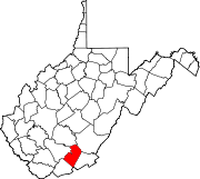
Unincorporated
communitiesBallengee‡ | Bargers Springs | Barksdale | Barnettown | Bertha | Beurytown | Brooklin | Brooks | Browning | Buck | Carew | Claypool | Clayton | Crossroads | Crumps Bottom | Ellison | Ellison Ridge | Elton | Farley | Forest Hill | Glenray | Green Sulphur Springs | Griffith Creek | Hill Top | Hilldale | Hix | Indian Mills | Judson | Jumping Branch | Lick Creek | Lockbridge | Lowell | Mandeville | Marie | Meadow Creek | Mountview‡ | Neponset | Nimitz | Pence Springs | Pipestem | Ramp | Riffe | Sandstone | Santafee | Seminole | Streeter | Suck Creek | Talcott | Tempa | True | Valley Heights | Wiggins
Ghost towns Egypt | Junta | Lilly | Mercers Saltworks | Tina | Warford
Footnotes ‡This populated place also has portions in an adjacent county or counties
Categories:- Populated places in Summers County, West Virginia
- Unincorporated communities in West Virginia
- New River Greenbrier geography stubs


Wikimedia Foundation. 2010.