Melville railway station

Melville railway station
Via Rail (inter-city rail)
Melville, SK VIA Station 1991.jpg
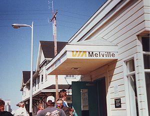
Station statistics
Address Main St & 1st Ave, Melville, SK
Coordinates 50°55′35″N 102°48′26″W / 50.9263°N 102.8072°W / 50.9263; -102.8072
Platforms 1
Tracks 1
Other information
Opened 1908
Formerly Grand Trunk Pacific Railway
Services
Preceding station   Via Rail   Following station
Watrous
toward Vancouver
Canadian
Rivers
toward Toronto

The Melville railway station is on the Canadian National Railway mainline in Melville, Saskatchewan, Canada. The station is served by Via Rail's The Canadian three times per week.[1] The station was declared a national historic site in 1992.[2]

The station building, built in 1908 by the Grand Trunk Pacific Railway (GTPR) design makes use of a twin-gabled plan that is unique in Saskatchewan, this reflects the special status the station had when built as a division point and junction on the GTPR line.[3] The town was named after Charles Melville Hays, former president of the GTPR.[4]

In 2010, the Melville Rail Station Heritage Association acquired title to the station building. The group plans to restore both the interior and exterior of the station.[5]

Footnotes

External links

Coordinates: 50°55′35″N 102°48′26″W / 50.9263°N 102.8072°W / 50.9263; -102.8072


Wikimedia Foundation. 2010.

Игры ⚽ Поможем написать реферат

Look at other dictionaries:

  • Kirkcaldy railway station — Infobox UK station name = Kirkcaldy code = KDY caption = Whyte Melville Road Entrance manager = First ScotRail locale = Kirkcaldy borough = Fife usage0405 = 1.050 usage0506 = 1.072 usage0607 = 1.126 platforms = 2 years = 20 June,1847 events =… …   Wikipedia

  • Tawa Railway Station — Infobox Station name=Tawa type=Metlink suburban rail image size= image caption= address=Melville Street, Tawa, Wellington, New Zealand coordinates=coord|41|10|9.48|S|174|49|42.20|E|type:railwaystation region:NZ| line=North Island Main Trunk other …   Wikipedia

  • Amlwch railway station — Infobox UK disused station| name = Amlwch| locale = Amlwch| borough = Anglesey| line = Anglesey Central Railway manager = LNWR owner = LMS years = 3 June 1865 events = Opened Richards, Melville: Atlas Môn, page 99. Cyngor Gwlad Môn, 1972] |… …   Wikipedia

  • Llangefni railway station — Infobox UK disused station| name = Llangefni| locale = Llangefni| borough = Anglesey| line = Anglesey Central Railway manager = LNWR owner = LMS years = 1865 events = Opened Richards, Melville: Atlas Môn, page 99. Cyngor Gwlad Môn, 1972] | years1 …   Wikipedia

  • Llangwyllog railway station — Infobox UK disused station| | name = Llangwyllog| locale = Llangwyllog| borough = Anglesey| line = Anglesey Central Railway manager = LNWR owner = LMS years = 1865 events = Opened Richards, Melville: Atlas Môn, page 99. Cyngor Gwlad Môn, 1972] |… …   Wikipedia

  • Llanerchymedd railway station — Infobox UK disused station| name = Llanerchymedd| locale = Llanerchymedd| borough = Anglesey| line = Anglesey Central Railway manager = LNWR owner = LMS years = 1865 events = Opened Richards, Melville: Atlas Môn, page 99. Cyngor Gwlad Môn, 1972]… …   Wikipedia

  • Rhosgoch railway station — Infobox UK disused station| name = Rhosgoch| locale = Rhosgoch| borough = Anglesey| line = Anglesey Central Railway manager = LNWR owner = LMS years = 1865 events = Opened Richards, Melville: Atlas Môn, page 99. Cyngor Gwlad Môn, 1972] | years1 …   Wikipedia

  • Melville, Saskatchewan — Melville Saskatchewan Highway 15 in Melville …   Wikipedia

  • Berwick railway station, Melbourne — MelbourneRailwayStation1 NAME=Berwick CODE=BEW DISTANCE=43.4 km LINES=Bairnsdale, Pakenham PLATFORMS=2 TRACKS=2 STATUS=Premium Station FACILITIES= [http://www.metlinkmelbourne.com.au/stop/view/19883 Link] TIMETABLES=… …   Wikipedia

  • Cumberland Street railway station — [v · d · …   Wikipedia

Share the article and excerpts

Direct link
Do a right-click on the link above
and select “Copy Link”