- Meeks Creek
-
Meeks Creek Meigs Creek[1] stream 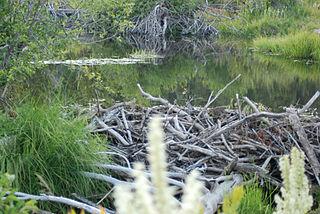 A beaver dam in Meeks Meadow with White-flowered bog orchid (Platanthera leucostachys) in foreground, 2010
Country United States State California Region El Dorado County City Meeks Bay, California Source Rubicon Lake - location Desolation Wilderness - elevation 2,400 ft (732 m) - coordinates 38°58′05″N 120°08′03″W / 38.96806°N 120.13417°W [1] Secondary source - elevation 8,300 ft (2,530 m) Mouth Lake Tahoe - location Meeks Bay, California - elevation 6,234 ft (1,900 m) [1] - coordinates 39°02′13″N 120°07′22″W / 39.03694°N 120.12278°W [1] Meeks Creek is a western tributary of Lake Tahoe which has its source on Rubicon Lake, 1.2 miles (1.9 km) northeast of Phipps Peak in Desolation Wilderness, trends northwest through Stony Ridge Lake, Shadow Lake, Crag Lake, and Lake Genevieve 3.5 miles (5.6 km), continues northeast 3.5 miles (5.6 km) to Meeks Bay on Lake Tahoe.[1] At its mouth is the tiny town of Meeks Bay, California, in El Dorado County, California, United States.
Contents
History
The stream and bay are named for John Meeks, who owned the land.[1] The Meeks brothers bailed 25 tons of wild hay in the meadows at the mouth of Meeks Creek in 1862.[2][2]
Ecology
North American beaver (Castor canadensis) are gradually restoring Meeks Meadow which had been overgrown with coniferous trees. This meadow is an important wildflower viewing area and is easy to access as the trail starts across from Meeks Bay Resort. Mallow, iris, meadow aster, buckwheat, wandering daisy, yarrow, yampah, phlox, scarlet gilia, monkshood, flax and lupine are just some of the flowers that one can see in bloom during the peak flowering time in late June–July.[3] A recent study of nearby Taylor Creek and Ward Creek showed that beaver dams increased wetland habitat, and decreased nutrients and sediments entering Lake Tahoe - all factors which postively impact the clarity of the lake's water.[4] The Washo people, who lived in the eastern Sierra with hunting grounds extending as far west as Calaveras County, have a word for beaver, c'imhélhel.[5][6]
Recreation
The Meeks Bay trail follows Meeks Creek, beginning just north of the California State Route 89 bridge over the stream. The first 1.4 miles is along a gentle gated road and parallels Meeks meadow, which after an additional mile meets a trail that courses southwest eventually meeting the Pacific Crest Trail between Phipps Peak and Middle Velma Lake. The total trail length to Rubicon Lake is 8 miles (13.33 km); to Stony Ridge Lake 6.3 miles; to Shadow Lake 5.9 miles; to Hidden Lake 5.7 miles; to Crag Lake 5 miles; to Genevieve Lake 4.5 miles.[7][8] Crag Lake is a popular day trip goal and swimming lake.
The lower 1.8 miles of trail are also excellent for snowshoeing (3.6 miles round trip and 1,000 feet elevation gain).[9]
See also
References
- ^ a b c d e f U.S. Geological Survey Geographic Names Information System: Meeks Creek
- ^ a b Durham, David L. (1998). California's Geographic Names: A Gazetteer of Historic and Modern Names of the State. Quill Driver Books. p. 522. http://books.google.com/books?id=Yfa0hmE7yocC&printsec=frontcover&dq=California's+Geographic+Names:+A+Gazetteer+of+Historic+and+Modern+Names+of+the+State&source=bl&ots=nGSWNOY0dP&sig=pCQsPHn6fcjD-1rnsyu_tejqRG4&hl=en&ei=u6NdTNzzBIn6swPg_JiqCw&sa=X&oi=book_result&ct=result&resnum=4&ved=0CCgQ6AEwAw#v=onepage&q=meeks%20bay&f=false. Retrieved 2010-08-07.
- ^ "Celebrating Wildflowers - Meeks Bay Trail". U. S. Forest Service. 2010-05-11. http://www.fs.fed.us/wildflowers/regions/pacificsouthwest/MeeksBay/index.shtml. Retrieved 2010-08-16.
- ^ Sarah Muskopf (October 2007). The Effect of Beaver (Castor canadensis) Dam Removal on Total Phosphorus Concentration in Taylor Creek and Wetland, South Lake Tahoe, California (Report). Humboldt State University, Natural Resources. http://hdl.handle.net/2148/264. Retrieved Jan. 17, 2010.
- ^ A. L. Kroeber (1919). "30". Handbook of Indians of California. http://www.yosemite.ca.us/library/kroeber/miwok.html. Retrieved 2010-08-19.
- ^ "The Washo Project". University of Chicago. http://washo.uchicago.edu/dictionary/results.php?AttestationID=2479&SearchBy=SearchGloss&SearchKey=beaver. Retrieved 2010-08-19.
- ^ "Meeks Bay Trail". Wildernet. http://activities.wildernet.com/pages/activity.cfm?actid=CALTBMUIO*57534hw&areaid=NV&rectype=Backpacking&startrecord=1&fromPage=summary&CU_ID=1. Retrieved 2010-08-16.
- ^ Ann Marie Brown (2006). Moon Tahoe. Avalon Travel Publishing. p. 114. ISBN 9781566919333. http://books.google.com/books?id=4iMDJ-WW4VMC&pg=PA114&lpg=PA114&dq=meeks+creek&source=bl&ots=kjdyTpWPYp&sig=zOkwBHVCLxQUPVfBapXEBTZaVR0&hl=en&ei=EhlqTLrmG53YtAOsmqjqCg&sa=X&oi=book_result&ct=result&resnum=4&ved=0CCEQ6AEwAzgU#v=onepage&q=meeks%20creek&f=false. Retrieved 2010-08-16.
- ^ Mike White (2005). Snowshoe Trails of Tahoe: Best Routes in the Tahoe Sierra. Wilderness Press. p. 191. ISBN 9780899973920. http://books.google.com/books?id=kLdcbQyBNHoC&pg=PA191&lpg=PA191&dq=meeks+creek&source=bl&ots=t9QWDyWlHn&sig=eGIF4s7xgsa-lOqst7ycKxjkJTA&hl=en&ei=gxVqTOCqNoqstAPkmPnpCg&sa=X&oi=book_result&ct=result&resnum=5&ved=0CCcQ6AEwBDgK#v=onepage&q=meeks%20creek&f=false. Retrieved 2010-08-16.
External links
Categories:- Rivers of El Dorado County, California

Wikimedia Foundation. 2010.