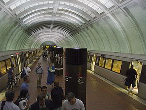
- Medical Center (WMATA station)
-
Medical Center 
Station statistics Address 8810 Rockville Pike
Bethesda, MD 20814Lines Connections WMATA Metrobus
Ride OnStructure Underground Platforms 1 island platform Tracks 2 Bicycle facilities 88 racks, 38 lockers Other information Opened August 25, 1984 Accessible 
Code A10 Owned by Washington Metropolitan Area Transit Authority Traffic Passengers (2006) 1.861 million  0.5%
0.5%Services Preceding station Washington Metro Following station Grosvenor–Strathmoretoward Shady GroveRed Line Bethesdatoward GlenmontMedical Center is an island platformed Washington Metro station in Bethesda, Maryland, United States. The station was opened on August 25, 1984, and is operated by the Washington Metropolitan Area Transit Authority (WMATA). Providing service for the Red Line, the station serves the National Institutes of Health campus and the National Naval Medical Center, also known as Bethesda Naval Hospital, and is located at Rockville Pike and South Drive. Since there is little retail in the area and no commuter parking lot, this station is used almost exclusively by employees of and visitors to those two institutions.
The station opened on August 25, 1984.[1][2] Its opening coincided with the completion of 6.8 miles (10.9 km) of rail northwest of the Van Ness–UDC station and the opening of the Bethesda, Friendship Heights, Grosvenor and Tenleytown stations.[1][2][3]
In September 2009, Montgomery County submitted a $20 million federal grant application to build a pedestrian tunnel under Wisconsin Avenue to improve access to the Medical Center stop. If funded, construction would occur in 2011.[4]
References
- ^ a b Staff Reporters (August 25, 1984), "Red Line adds 6.8 miles; Opening ceremony for new segment set for today at Friendship Heights", The Washington Post: B1
- ^ a b Brisbane, Arthur S. (August 26, 1984), "All aboard; Metro festivities welcome latest Red Line extension", The Washington Post: A1
- ^ Washington Metropolitan Area Transit Authority (July 2009). "Sequence of Metrorail openings". http://www.wmata.com/about_metro/docs/metrofacts.pdf. Retrieved August 1, 2010.
- ^ Ujifusa, Andrew (September 16, 2009). "County proposes underpass for Medical Center Metro station". Montgomery County Gazette. http://www.gazette.net/stories/09162009/montnew170358_32544.shtml. Retrieved December 10, 2010.
External links
 Media related to Medical Center (Washington Metro) at Wikimedia Commons
- WMATA: Medical Center Station
- StationMasters Online: Medical Center Station
- The Schumin Web Transit Center: Medical Center Station
- NIH Gateway Center construction map: [1]
- South Drive entrance from Google Maps Street View
Coordinates: 38°59′57″N 77°05′52″W / 38.999067°N 77.097676°W


This Maryland train station-related article is a stub. You can help Wikipedia by expanding it.
