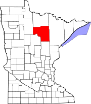
- Max, Minnesota
-
Max, Minnesota — Unincorporated community — Coordinates: 47°36′53″N 94°04′05″W / 47.61472°N 94.06806°WCoordinates: 47°36′53″N 94°04′05″W / 47.61472°N 94.06806°W Country United States State Minnesota County Itasca Elevation 1,371 ft (418 m) Time zone Central (CST) (UTC-6) – Summer (DST) CDT (UTC-5) ZIP code 56659 Area code(s) 218 GNIS feature ID 657341[1] Max is an unincorporated community in Itasca County, Minnesota, United States.
The community is located 3.5 miles (5.6 km) southeast of Squaw Lake at the junction of Itasca County Roads 4 and 34. Minnesota State Highway 46 is nearby.
Max has a post office with ZIP code 56659.[2]
References
- ^ "US Board on Geographic Names". United States Geological Survey. 2007-10-25. http://geonames.usgs.gov. Retrieved 2008-01-31.
- ^ ZIP Code Lookup
Municipalities and communities of Itasca County, Minnesota Cities Bigfork | Bovey | Calumet | Cohasset | Coleraine | Deer River | Effie | Grand Rapids | Keewatin | La Prairie | Marble | Nashwauk | Squaw Lake | Taconite | Warba | Zemple
Townships Alvwood | Arbo | Ardenhurst | Balsam | Bearville | Bigfork | Blackberry | Bowstring | Carpenter | Deer River | Feeley | Good Hope | Goodland | Grand Rapids | Grattan | Greenway | Harris | Iron Range | Kinghurst | Lake Jessie | Lawrence | Liberty | Lone Pine | Marcell | Max | Moose Park | Morse | Nashwauk | Nore | Oteneagen | Pomroy | Sago | Sand Lake | Spang | Splithand | Stokes | Third River | Trout Lake | Wabana | Wawina | Wildwood | Wirt
Unorganized
territoriesUnincorporated
communitiesIndian
reservationsCategories:- Populated places in Itasca County, Minnesota
- Unincorporated communities in Minnesota
- Arrowhead region geography stubs
Wikimedia Foundation. 2010.


