- Maula Kalika
-
Maula Kalika is a famous Hindu temple of Goddess Kalika in Gaindakot town of Nawalparasi district in Lumbini zone of Nepal.
Maula Kalika is a very famous and growing tourist destination located in Gaindakot town of Nepal. Located on the top of the Maula hill on the north of Narayani River (also called Gandaki River) in Gaindakot, Maula Kalika temple is situated 561 meter above the sea level.
Contents
History
Historically, it is said that in 16th century the King of Palpa created a symbolic offering site ("Maula") in the name of goddess Kalika after which the name of the mountain (Maula hill) was derived.
It is believed, in Hindu mythology that the Goddess Kali or Kalika also called Durga is the symbol of energy, power and new beginning.
Popularity
Local people in Gaindakot have been worshiping at the Maula Kalika for many centuries before it got wide spread popularity quite recently. The current temple was built in the early 1990's.
Hundreds of thousands of people visit Maula Kalika every year from Nepal and neighboring countries. Dasain or Dussera festival in September-October and in March-April are peak seasons when goddess Kalika (also called Nav Durga, the 9 different incarnation of Goddess Kalika) is worshiped during these festive season.
President of Nepal Dr. Ram Baran Yadav, former King/Princes and government officials of Nepal and world famous Yoga guru Baba Ramdev from India recently visited the temple.
Hiking
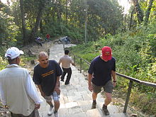 Hiking is popular at Maulakalila
Regular visitors from Gaindakot and nearby towns of Narayanghat, Bharatpur, Nepal and Chitwan to this place choose as a destination to entertain their leisure time with the feel of cool breeze, observation of wide panoramic views of wilderness and exciting adventure of walking through 2000 meters long slopy & curvy stairs to attain the height of final destination.
Visitors enjoy panoramic view of Narayani River, Gaindakot town and Chitwan valley on the south of the hill. Mt.Manaslu can be viewed on the north side. Hikers also prefer to visit the temple for good-morning sunrise view early in the morning.
It is trending that tourists now who visit Chitwan National Park and Lumbini also add Maula Kalika in Gaindakot as an additional most-visit tourist destination. It takes less then a half-day for a round trip from Narayanghat town traveling on foot. From the bottom of the Maula hill it only requires less then 4 hours for top and down. Mineral water and refreshments are available on the way, near Deurali where there is a helipad too.
Transportaion
By Air
The closest airport is at Bharatpur Airport, where are flights to and from Kathmandu and Pokhara are served.
By Bus
It's a 5 hour drive from the capital city Kathmandu. Travel from Lumbini (the birthplace of Lord Buddha in Nepal) and Birganj near the Indian border is about 3 hours travel by bus or car.
Local Transport
Taxi's, rickshaw's are available in Narayanghat town. Narayanghat is less then 15 minutes walk from Gaindakot.
By Railroad
There is no railway system in Nepal except a small line service in Janakpur, Nepal. Visitors from India or China can take a bus (or taxi if available) from Nepal border.
See also
External links
Categories:- Hindu goddesses
- Hindu Temple
- Tourist Spot in Nepal


Wikimedia Foundation. 2010.