- Matapédia Valley
-
Matapédia Valley Vallée de la Matapédia 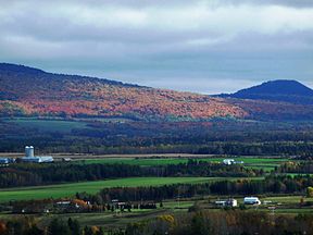
The Chic-Choc mountains, which form the Matapédia Valley.Gaspésie–Îles-de-la-Madeleine,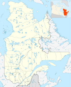
 Matapédia Valley
 Quebec,
  Canada
Long-axis direction southwest Long-axis length 375 km (233 mi) Geological type river valley Coordinates 48°30′N 67°20′W / 48.5°N 67.333°WCoordinates: 48°30′N 67°20′W / 48.5°N 67.333°W Population Centers Amqui Traversed by  Route 132
The Matapédia Valley was formed by the Chic-Choc Mountains of eastern Québec. Its name is derived from the river that traverses the valley, as well as the lake that lies in its center. It is situated in the southwest of the Gaspé peninsula and stretches 375 km (233 mi).
The land is primarily made up of forest and agriculture, and is home to more than 20,000 inhabitants in some thirty municipalities. Most of them are concentrated along the main avenue of communication, Route 132. The city of Amqui is the seat of the RCM and is home to 6,261 people.
The Mi'kmaq people first developed the valley around 500 BCE. French-Canadian settlement began in 1833 when Pierre Brochu moved to Lake Matapédia along Kempt road.[citation needed] Settlers began flocking to the land in the late nineteenth century with the development of land clearing, agriculture, and the logging industry.[citation needed]
Toponymy
"Matapédia" comes from the Micmac matapegiag which means "river junction," as mata means junction and pegiag, river. The spellings "Matapeguia," "Malapediach," and "Matapediac" have also been used in the past.[1]
References
- ^ "Lac Matapédia" (in French). Commission de toponymie du Québec. http://www.toponymie.gouv.qc.ca/CT/toposweb/fiche.aspx?no_seq=39701. Retrieved 24 Oct. 2009.
External links
Categories:- Articles in translation
- Gaspé Peninsula
- Geography of Quebec
- Bas-Saint-Laurent
- Valleys of Canada


Wikimedia Foundation. 2010.