- Marong
-
Marong
Victoria
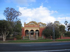
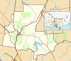
The former Shire Hall at MarongPopulation: 393 (2006)[1] Postcode: 3515 Location: LGA: City of Greater Bendigo State District: Bendigo East, Bendigo West Federal Division: Division of Bendigo Marong is a town in Victoria, Australia. At the 2001 census, Marong had a population of 393.[2] It is located 17 kilometres (11 mi) kilometres to the west of Bendigo. Its local government area is the City of Greater Bendigo. The town is located at the junction of the Calder Highway (A79) and the Calder Alternate Highway (A790).
Contents
History
The Post Office opened on 1 January 1860. [3]
The Town today
The town has an Australian Rules football team competing in the Loddon Valley Football League known as the Marong Panthers.
Golfers play at the course of the Marong Golf Club on Ravenswood Road. [4]
There is also a primary school, Marong Primary School, and a kindergarten. The Marong Family Hotel is the local pub and the Marong Swimming pool provides the surrounding districts with aquatic facilities.[citation needed]
References
- ^ Australian Bureau of Statistics (25 October 2007). "Marong (State Suburb)". 2006 Census QuickStats. http://www.censusdata.abs.gov.au/ABSNavigation/prenav/LocationSearch?collection=Census&period=2006&areacode=SSC26105&producttype=QuickStats&breadcrumb=PL&action=401. Retrieved 23 May 2010.
- ^ Australian Bureau of Statistics (25 October 2007). "Marong (L) (Urban Centre/Locality)". 2006 Census QuickStats. http://www.censusdata.abs.gov.au/ABSNavigation/prenav/LocationSearch?collection=Census&period=2006&areacode=UCL231500&producttype=QuickStats&breadcrumb=PL&action=401. Retrieved 23 May 2010.
- ^ Premier Postal History, Post Office List, https://www.premierpostal.com/cgi-bin/wsProd.sh/Viewpocdwrapper.p?SortBy=VIC&country=, retrieved 2008-04-11
- ^ Golf Select, Marong, http://www.golfselect.com.au/armchair/courseView.aspx?course_id=1021, retrieved 2009-05-11
External links
- Marong is at coordinates 36°44′02″S 144°08′02″E / 36.734°S 144.134°ECoordinates: 36°44′02″S 144°08′02″E / 36.734°S 144.134°E
- domain.com.au: Marong
- Geoscience Australia place names search: Marong
Suburbs and Towns in the City of Greater Bendigo Local Government Area Suburbs: Ascot · Bendigo · California Gully · Eaglehawk · Eaglehawk North · East Bendigo · Epsom · Flora Hill · Golden Gully · Golden Square · Ironbark · Jackass Flat · Junortoun · Kangaroo Flat · Kennington · Long Gully · Maiden Gully · North Bendigo · Quarry Hill · Sailors Gully · Spring Gully · Strathdale · Strathfieldsaye · West Bendigo · White Hills
Outlying Towns: Argyle · Avonmore · Axe Creek · Axedale · Bagshot · Bagshot North · Barnerdown · Big Hill · Costerfield · Derrinal · Drummartin · Elmore · Emu Creek · Eppalock · Fosterville · Goornong · Harcourt · Heathcote · Hunter · Huntly · Huntly North · Junortoun · Kamarooka · Kimbolton · Knowsley · Ladys Pass · Leikhart · Lockwood · Lockwood South · Longlea · Lyal · Mandurang · Mandurang South · Marong · Mia Mia · Mount Camel · Myrtle Creek · Myers Flat · Neilborough · Ravenswood · Raywood · Redcastle · Redesdale · Sedgwick · Sebastian · Shelbourne · Tooleen · Wellsford · Whipstick · Wilsons Hill · Woodvale
Categories:- Towns in Victoria (Australia)
- Australian Aboriginal placenames
- Victoria (Australia) geography stubs
Wikimedia Foundation. 2010.


