Maple Mountain (Ontario)

Maple Mountain (Ontario)
Maple Mountain

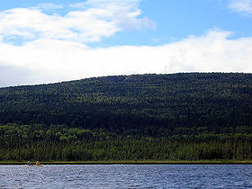
Maple Mountain rising over Tupper Lake
Elevation 642 m (2,106 ft)
Prominence 351 m (1,152 ft)
Location
Maple Mountain is located in Ontario
Maple Mountain
Temagami, Ontario
Range Canadian Shield, unnamed range
Coordinates 47°23′N 80°20′W / 47.383°N 80.333°W / 47.383; -80.333Coordinates: 47°23′N 80°20′W / 47.383°N 80.333°W / 47.383; -80.333
Climbing
Easiest route Hike

Maple Mountain is a mountain, located within Lady Evelyn-Smoothwater Provincial Park, Temagami, Ontario, Canada, estimated 642 m (2,106 ft) above mean sea level. It has a higher vertical rise over the surrounding landscape, 37 m (121 ft) higher than the Ishpatina Ridge, which is the highest point of land in Ontario rising over Scarecrow Lake. Maple Mountain rises over Tupper Lake and is considerably better known than Ishpatina Ridge. It ranks thirteenth, but when ranked by vertical rise it is the highest of the top 25 peaks in Ontario. The 100-ft fire tower is also still intact and attracts many hikers. A 3.2 kilometre long hiking trail leads to the abandoned fire tower.

Located in Timiskaming District of Northeastern Ontario, the mountain is not very accessible; roads and trails in the remote area are difficult to travel in poor weather. The most popular approach routes to Maple Mountain are by canoe and/or float plane.

The indigenous Temagami First Nation call the mountain Chee-bay-jing, meaning "the place where the spirits go" and consider it a sacred site. The English name of the mountain was given by Dr. Robert Bell of the Geological Survey of Canada in 1888. Bell was the first known non-aboriginal to scale the mountain.

See also

External links


Wikimedia Foundation. 2010.

Игры ⚽ Поможем написать реферат

Look at other dictionaries:

  • Maple Mountain — may refer to: Maple Mountain (British Columbia) Maple Mountain (Maine) Maple Mountain (New Hampshire) Maple Mountain (Oneida County, New York) Maple Mountain (St. Lawrence County, New York) Maple Mountain (Ontario) Maple Mountain (Washington)… …   Wikipedia

  • Maple (disambiguation) — Maple is a genus of trees and shrubs in the family Aceraceae. Maple may also refer to: Flowering maple or Abutilon, a genus of shrubs in the family Malvaceae Contents 1 Places 1.1 Canada 1.2 United States …   Wikipedia

  • Maple, Ontario — Maple   Unincorporated community   Wonder Mountain at Canada s Wonderland is an unusual landmark in Maple …   Wikipedia

  • Maple Creek No. 111, Saskatchewan — Maple Creek No. 111 Coordinates: 49°42′06″N 109°38′13″W /  …   Wikipedia

  • Maple Lawn — U.S. National Register of Historic Places …   Wikipedia

  • Ontario Highway 17 — Highway 17 Trans Canada Highway …   Wikipedia

  • Ontario — Ontarian, Ontaric /on tar ik/, adj., n. /on tair ee oh /, n. 1. a province in S Canada, bordering on the Great Lakes. 8,131,618; 412,582 sq. mi. (1,068,585 sq. km). Cap.: Toronto. 2. Lake, a lake between the NE United States and S Canada, between …   Universalium

  • Temagami, Ontario — Temagami is a region and a municipality in northeastern Ontario, Canada, in the District of Nipissing with Lake Temagami at its heart.According to the 2006 Statistics Canada Census for the Municipality of Temagami: *Population: 934 *% Change… …   Wikipedia

  • High Rock (Ontario) — High Rock is a large hill, located in the middle of Lake Temagami, Ontario, Canada. It contains one of the many lookouts on Lake Temagami and is the highest point on High Rock Island and Lake Temagami and contains a steep trail on its slopes… …   Wikipedia

  • Caribou Mountain — is a large hill, located 1.5 kilometers to the east of the town of Temagami, Ontario, Canada. When driving north through the town, turn right just before Temagami Train Station and follow the road and signs. It contains a Unit m|30|0 high fire… …   Wikipedia

Share the article and excerpts

Direct link
Do a right-click on the link above
and select “Copy Link”