- Manufahi District
-
Manufahi — District — 
FlagMap of East Timor highlighting Manufahi District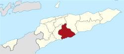
Coordinates: 9°00′S 125°47′E / 9°S 125.783°ECoordinates: 9°00′S 125°47′E / 9°S 125.783°E Country  East Timor
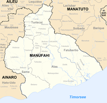
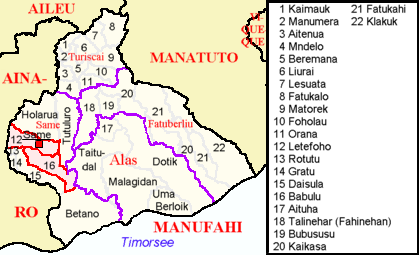
Capital Same Subdistricts Alas, Fatuberlio, Same, Turiscai Area - Total 1,325 km2 (511.6 sq mi) Area rank 6th Population (2004) - Total 44,950 - Rank 11th - Density 33.9/km2 (87.9/sq mi) - Density rank 11th Households - Total 8,901 (as of 2004) - Rank 11th Time zone UTC+9 ISO 3166 code TL-MF Manufahi is one of the districts of East Timor. It has a population of 44,235 (2004 census) and an area of 1,325 km2. The capital of the district is Same. The subdistricts are Alas, Fatuberlio, Same, and Turiscai. In the times of the Portuguese colony, the district was called Same, after the capital city. During the Indonesian occupation the subdistrict Hato-Udo was split off from the district and joined to Ainaro, and the subdistrict Turiscai, previously in Ainaro, was moved to Manufahi.
Manufahi lies on the south coast of East Timor, on the Timor Sea. It borders the district Manatuto to the east, Ainaro to the west, and Aileu to the north.
Besides the national official languages of Tetum and Portuguese, the Malayo-Polynesian language Mambai is also spoken.
 Subdivisions of Manufahi
 Cities of Manufahi
References
Districts of East Timor  Categories:
- Geography articles needing translation from German Wikipedia
- Districts of East Timor
- East Timor geography stubs


Wikimedia Foundation. 2010.