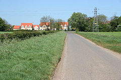
Manthorpe, Bourne

Manthorpe, Bourne

Coordinates: 52°55′47″N 0°37′57″W / 52.9296050°N 0.6324622°W / 52.9296050; -0.6324622

Manthorpe
Manthorpe, Lincolnshire - geograph.org.uk - 420112.jpg
Manthorpe
Manthorpe is located in Lincolnshire
Manthorpe

 Manthorpe shown within Lincolnshire
OS grid reference SK920377
District South Kesteven
Shire county Lincolnshire
Region East Midlands
Country England
Sovereign state United Kingdom
Post town Bourne
Postcode district NG31
Police Lincolnshire
Fire Lincolnshire
Ambulance East Midlands
EU Parliament East Midlands
UK Parliament Sleaford and North Hykeham
List of places: UK • England • Lincolnshire

Manthorpe is a small village in South Kesteven in Lincolnshire.

It is situated about two miles west of Thurlby and three miles south-west along the A6121 from Bourne. A mile to the west is Witham on the Hill.

The village is notable for being on the edge of the Fens, and there is a slight rising between the village and Thurlby. Passing through the western edge of the village is the East Glen River, where there is a bridge.

It is part of the Toft with Lound and Manthorpe parish.

At Bowthorpe Park Farm is an oak tree, the Bowthorpe Oak, with the largest girth in the UK, with a circumference of forty feet.

External links

Media related to Manthorpe, Bourne at Wikimedia Commons


Wikimedia Foundation. 2010.

Игры ⚽ Поможем написать курсовую

Look at other dictionaries:

  • Manthorpe — is the name of two places, both in the South Kesteven district of Lincolnshire, England Manthorpe, Grantham Manthorpe, Bourne This disambiguation page lists articles about distinct geographical locations with the same name. If an …   Wikipedia

  • South Kesteven — Infobox UK district name = South Kesteven District status = District region = East Midlands admincounty = Lincolnshire area = Ranked 31st 942.59 km² adminhq = Grantham onscode = 32UG population = Ranked English district rank|ONS=32UG English… …   Wikipedia

  • Grantham — For other uses, see Grantham (disambiguation). Coordinates: 52°55′05″N 0°38′17″W / 52.918°N 0.638°W / 52.918; 0.638 …   Wikipedia

  • Delaine Buses — The Delaine logo. The first ever East Lancs Olympus, seen at the 2007 Longcross bus rally …   Wikipedia

  • Witham on the Hill — is a well maintained [http://www.geograph.org.uk/photo/203021 village] in the civil parish of the same name. Coordinates 52°44.04 N 0°26.26 W. It lies in the district of South Kesteven in south west Lincolnshire, between Stamford and Bourne.The… …   Wikipedia

  • List of civil parishes in Lincolnshire — This is a list of civil parishes in the ceremonial county of Lincolnshire, England. =Boston= Boston itself is an unparished area.*Algarkirk *Amber Hill *Benington *Bicker *Butterwick *Fishtoft *Fosdyke *Frampton *Freiston *Holland Fen with… …   Wikipedia

  • List of places in Lincolnshire — This is a list of places in the ceremonial county of Lincolnshire, England. See the list of places in England for places in other counties.compactTOC NOTOC A *Aby, Addlethorpe, Aisby, South Kesteven, Aisby, West Lindsey, Aisthorpe, Alford,… …   Wikipedia

  • Toft, Lincolnshire — infobox UK place country = England latitude= 52.7423 longitude= 0.4151 official name= Toft population= shire district= South Kesteven shire county = Lincolnshire region= East Midlands constituency westminster= Grantham and Stamford post town=… …   Wikipedia

  • Navenby — Coordinates: 53°06′36″N 0°31′26″W / 53.110°N 0.524°W / 53.110; 0.524 …   Wikipedia

Share the article and excerpts

Direct link
Do a right-click on the link above
and select “Copy Link”