- Dutch Houses, Chester
-
Coordinates: 53°11′23″N 2°53′30″W / 53.1897°N 2.8916°W
Dutch Houses, Chester 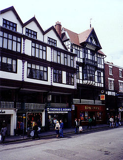 The Dutch Houses comprise the three bays on the left
Location: 20, 22 and 24 Bridge Street Row, Chester, Cheshire, England OS grid reference: SJ 405 662 Built: c. 1670 Rebuilt: 1973–75 Restored by: Chester City Council Listed Building – Grade II Designated: 28 July 1955 Reference #: 1376071 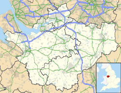
 Location in Cheshire
The Dutch Houses are located at 20, 22 and 24 Bridge Street Row, Chester, Cheshire, England. They have been designated by English Heritage as a Grade II listed building.[1]
History
The building was erected in about 1670, possibly above earlier undercrofts. The name reflects the trade undertaken with the Low Countries around that time. At the time it was built, it was the tallest and most impressive building in Bridge Street, and remained so for over 200 years. By the 1970s the building was in a state of decay, and it was restored and rebuilt in 1973–75 by Chester City Council. The rebuilding involved removing the whole of the façade and rebuilding it, and replacing the internal timberwork with steel. In the process many of the internal features were lost.[2]
Architecture
The Dutch Houses are constructed on sandstone piers, probably originating from the medieval period, with timber framing from the late 17th century, and rendered brickwork from the late 17th or the 18th century. It consists of three bays in four storeys plus an attic. The bottom storey incorporates the undercrofts, and a portion of the Chester Rows passes through the first floor. The lowest storey. at street level, includes modern shop fronts. At the level of the Row are painted wood barley sugar balusters with rails. Behind these are stallboards, the paved walkway of the Row, and more modern shop fronts. The third and fourth storeys are jettied, both containing barley sugar pilasters and casement windows of varying sizes. The attic storey is set back, each bay containing a three-light mullioned and transomed window.[1]
References
- ^ a b Number 20, 22 and 24 Row the Dutch Houses number 22, 26 and 28 Street, Bridge Street, Chester (1376071). National Heritage List for England. English Heritage. Retrieved 1 November 2011.
- ^ Langtree, Stephen; Comyns, Alan, eds. (2001), 2000 Years of Building: Chester's Architectural Legacy, Chester: Chester Civic Trust, p. 106, ISBN 0-9540152-0-7
Categories:- Buildings and structures in Chester
- Grade II listed buildings in Cheshire
- Timber framed buildings
- Medieval architecture
- 17th-century architecture


Wikimedia Foundation. 2010.