- Dukan Dam
-
Dukan Dam 
Location As Sulaymaniyah Governorate, Iraq Coordinates 35°57′15″N 44°57′10″E / 35.95417°N 44.95278°ECoordinates: 35°57′15″N 44°57′10″E / 35.95417°N 44.95278°E Construction began 1954 Opening date 1959 Dam and spillways Type of dam Arch Height 116.5 m (382 ft) Length 360 m (1,180 ft) Impounds Little Zab Reservoir Creates Lake Dukan Capacity 6.8–8.3 km3 (1.6–2.0 cu mi) Surface area 270 km2 (100 sq mi) Power station Installed capacity 400 MW 
 Dukan Dam
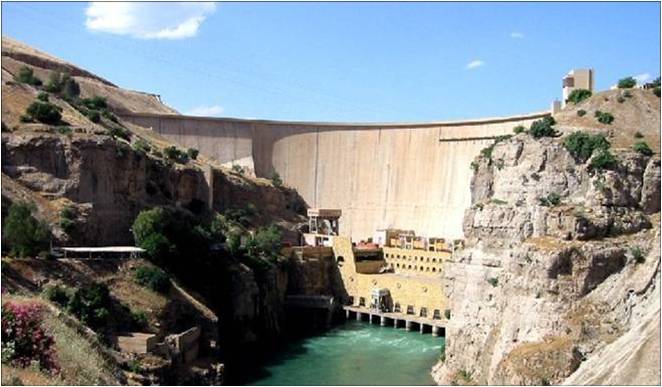
The Dukan Dam is a multi-purpose concrete arch dam in As Sulaymaniyah Governorate, Iraq. It impounds the Little Zab, thereby creating Lake Dukan. The Dukan Dam was built between 1954 and 1959 whereas its power station became fully operational in 1979. The dam is 360 metres (1,180 ft) long and 116.5 metres (382 ft) high and its hydroelectric power station has a maximum capacity of 400 MW.
Contents
Project history
The Dukan Dam was built between 1954 and 1959 as a multi-purpose dam to provide water storage, irrigation and hydroelectricity.[1] The design for the dam was carried out by the British engineering company Binnie & Partners.[2] Prior to the flooding of Lake Dukan, the area has been subjected to archaeological research to investigate as many archaeological sites as possible. An archaeological survey in the Ranya Plain documented some 40 archaeological sites with evidence for occupation ranging from the sixth millennium BCE up to the present. Five of these sites were then excavated: Tell Bazmusian, ed-Dem, Kamarian, Qarashina and Tell Shemshara. The excavations at Tell Bazmusian revealed a temple dating to the second millennium BCE.[3] At Tell Shemshara, an early-sixth millennium BCE village was excavated, as well as an early-second millennium BCE palace with a small archive of clay tablets.[4][5] The inhabitants of some 50 villages in the flooded area, around 1,000–1,200 families, were resettled to the west of the lake.[6] The power station was designed in 1973 by the Russian company Hydroproject and became operational in 1979. Due to lack of maintenance and repairs, the power station has underperformed and is now, after 30 years of service, due for replacement.[2][7]
The Russian made turbine control units are gradually being replaced. Turbine number 1 control unit was replaced in 2010 with an Italian made unit. The turbines themselves are still serviceable according to engineers at the dam project in March 2011.
Characteristics of the dam
The Dukan Dam is a multi-purpose concrete arch dam abutted by gravity monoliths. It is 360 metres (1,180 ft) long and 116.5 metres (382 ft) high. At its base it is 32.5 metres (107 ft) wide, tapering off to 6.2 metres (20 ft) at the top.[6][8] The combined maximum discharge of the dam is 4,300 cubic metres (150,000 cu ft) per second. This is divided over a spillway tunnel with three radial gates having a combined maximum discharge of 2,440 cubic metres (86,000 cu ft) per second, and an emergency bellmouth gloryhole spillway with a capacity of 1,860 cubic metres (66,000 cu ft) per second. Two irrigation outlets with a combined discharge of 220 cubic metres (7,800 cu ft) per second have not been operated over the last ten years. The powerhouse of five Francis units at 80 MW each releases between 110 and 550 cubic metres (3,900 and 19,000 cu ft) per second.[8] Lake Dukan, the reservoir created by the Dukan Dam, has a surface area of 270 square kilometres (100 sq mi). Its anticipated capacity is 6.8 cubic kilometres (1.6 cu mi) with a maximum of 8.3 cubic kilometres (2.0 cu mi).[6]
See also
- List of dams and reservoirs in Iraq
References
- ^ Kliot, Nurit (1994). Water Resources and Conflict in the Middle East. Milton Park: Routledge. ISBN 0415097525.
- ^ a b Fink, A.K.; Ostrizhnov, I.D. (1984). "Dokan hydroelectric station in Iraq". Power Technology and Engineering 17 (10): 519–522. doi:10.1007/BF01425181.
- ^ Al-Soof, Behnam Abu (1970). "Mounds in the Rania Plain and excavations at Tell Bazmusian (1956)". Sumer 26: 65–104. ISSN 0081-9271.
- ^ Eidem, Jesper; Læssøe, Jørgen (2001). The Shemshara archives 1. The letters. Historisk-Filosofiske Skrifter. 23. Copenhagen: Kongelige Danske videnskabernes selskab. ISBN 8778762456.
- ^ Mortensen, Peder (1970). Tell Shimshara. The Hassuna period. Historisk-Filosofiske Skrifter. 5, 2. Copenhagen: Kongelige Danske videnskabernes selskab. OCLC 562453801.
- ^ a b c Jwaideh, Albertine (1996). "Dukan Dam". In Simon, Reeva S.; Mattar, Philip; Bulliet, Richard W.. Encyclopedia of the modern Middle East. New York: Macmillan Reference. pp. 587–588. ISBN 0028960114.
- ^ "Dokan and Derbandikhan Emergency Hydro Power Project" (pdf). www.krg.org. 2006. http://www.krg.org/pdf/WBPID_HydroPower.pdf. Retrieved 11 February 2011.
- ^ a b Iraqi Ministries of Environment, Water Resources and Municipalities and Public Works (2006). "Annex III: Main water control structures (dams and water diversions) and reservoirs". New Eden Master Plan for integrated water resources management in the marshlands areas. New Eden Group.
Categories:- Dams in Iraq
- Hydroelectric power stations in Iraq
- Sulaymaniyah Governorate

Wikimedia Foundation. 2010.