Dischmabach

Dischmabach
Dischmabach

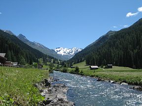
Dischmabach in the Dischma valley
Origin Two headwaters come together in Dürrboden
Mouth

Confluence with the Landwasser,

46°48′5″N 9°50′16″E / 46.80139°N 9.83778°E / 46.80139; 9.83778
Progression Landwasser → Albula → HinterrheinRhineNorth Sea
Basin countries Switzerland
Location Graubünden
Length 15 km (9.3 mi)
Source elevation 2,700 m (8,900 ft)
Mouth elevation 1,550 m (5,090 ft)
River system Rhine

The Dischmabach is a river of approximately 15 km long in the river system of Albula. It drains the Dischma valley, its catchment area lies mainly in the area of ​​the Swiss municipality of Davos.

The source Dischmabach has two equal headwaters. The one on the National Map of Switzerland is a creek without a registered name and has its headwaters in the area of ​​the Scaletta Pass (46°41′35.76″N 9°55′30.83″E / 46.6932667°N 9.9252306°E / 46.6932667; 9.9252306 (source of the Dischmabach)Coordinates: 46°41′35.76″N 9°55′30.83″E / 46.6932667°N 9.9252306°E / 46.6932667; 9.9252306 (source of the Dischmabach)). The other headwater is called Furggabach and has its headwaters on Fuorcla Grialetsch at (46°43′3.77″N 9°57′3.02″E / 46.7177139°N 9.9508389°E / 46.7177139; 9.9508389 (source of the Furggabach)). The confluence of the two headwaters is at Dürrboden. Then the Dischmabach flows in a northwesterly direction through the elongated and gently sloping Dischma valley and flows into the Landwasser between Davos Dorf and Davos Platz.

Within the Posterior Rhine system, the sources of Dischmabach are about 72 km from the confluence of the Anterior and Posterior Rhine. Only the headwaters Rein da Medel, Rein da Maighels and Rein da Curnera in the Vorderrhein system are further away from this confluence (about 74–76 km). Thus the Dischmabach is, in terms of length, one of the most important headwaters of the Rhine (see also sources of the Rhine).

  • This page is a translation of its German equivalent.


Wikimedia Foundation. 2010.

Игры ⚽ Поможем написать реферат

Look at other dictionaries:

  • Dischmabach — Vorlage:Infobox Fluss/KARTE fehlt Daten Gewäss …   Deutsch Wikipedia

  • Rheinquellen — Dieser Artikel behandelt die Quelle des Flusses Rhein in der Schweiz. Für die ehemalige Tageszeitung «Die Rheinquellen» aus Graubünden siehe Die Rheinquellen. Der Vorderrhein in der Schlucht Ruinaulta Als Quelle des Rheins wird oft der Tomasee im …   Deutsch Wikipedia

  • Landwasser (Albula) — Landwasser Das Landwasser bei Davos Islen, Richtung SWVorlage:Infobox Fluss/KARTE fehlt Daten …   Deutsch Wikipedia

  • Rheinquelle — Der Vorderrhein in der Schlucht Ruinaulta Als Quelle des Rheins gilt der Tomasee im Kanton Graubünden, dessen Ausfluss nach wenigen Kilometern als Rein da Tuma im Vorderrhein (romanisch Rein Anteriur) aufgeht. Der Verlauf seines Wassers ist dabei …   Deutsch Wikipedia

  • Bijlands Kanaal — Vorlage:Infobox Fluss/DGWK fehltVorlage:Infobox Fluss/QUELLHÖHE fehltKoordinaten fehlen! Hilf mit.Vorlage:Infobox Fluss/MÜNDUNGSHÖHE fehltVorlage:Infobox Fluss/HÖHENUNTERSCHIED fehltVorlage:Infobox Fluss/KARTE fehlt Rhein …   Deutsch Wikipedia

  • Flüsse der Schweiz — Der Artikel Hydrographie der Schweiz stellt den Haushalt, das Vorkommen, die Erscheinungsformen und die Nutzung des Wassers in der Schweiz dar. Karte der Schweiz mit den grössten Flüssen, Seen, sowie Kantonen und ihren Hauptstädten… …   Deutsch Wikipedia

  • Hinterrhein — Alpen , Vorder und Hinterrhein Daten Gew …   Deutsch Wikipedia

  • Niederrhein (Fluss) — Vorlage:Infobox Fluss/DGWK fehltVorlage:Infobox Fluss/QUELLHÖHE fehltKoordinaten fehlen! Hilf mit.Vorlage:Infobox Fluss/MÜNDUNGSHÖHE fehltVorlage:Infobox Fluss/HÖHENUNTERSCHIED fehltVorlage:Infobox Fluss/KARTE fehlt Rhein …   Deutsch Wikipedia

  • Pannerdens Kanaal — Vorlage:Infobox Fluss/DGWK fehltVorlage:Infobox Fluss/QUELLHÖHE fehltKoordinaten fehlen! Hilf mit.Vorlage:Infobox Fluss/MÜNDUNGSHÖHE fehltVorlage:Infobox Fluss/HÖHENUNTERSCHIED fehltVorlage:Infobox Fluss/KARTE fehlt Rhein …   Deutsch Wikipedia

  • Rheinkilometer — Vorlage:Infobox Fluss/DGWK fehltVorlage:Infobox Fluss/QUELLHÖHE fehltKoordinaten fehlen! Hilf mit.Vorlage:Infobox Fluss/MÜNDUNGSHÖHE fehltVorlage:Infobox Fluss/HÖHENUNTERSCHIED fehltVorlage:Infobox Fluss/KARTE fehlt Rhein …   Deutsch Wikipedia

Share the article and excerpts

Direct link
Do a right-click on the link above
and select “Copy Link”