- Digges Sound
-
Digges Sound 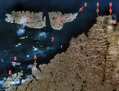
Digges Sound (7) and surrounding islands and mainland. Click on image for full legend. Coordinates 62°55′N 077°58′W / 62.917°N 77.967°WCoordinates: 62°55′N 077°58′W / 62.917°N 77.967°W Countries Canada Surface area 12 km2 (4.6 sq mi)
Digges Sound is a Canadian Arctic waterway in Qikiqtaaluk, Nunavut, Canada. The sound is located at the juncture where the Hudson Strait meets northeastern Hudson Bay close to the northern tip of the Ungava Peninsula, between Digges Islands and Cape Wolstenholme. Ivujivik, Quebec, the northernmost settlement in any Canadian province, is located on the south coast of the sound.Henry Hudson named many Arctic geographical features after patrons who financed his voyages, including Digges Sound in honor of Dudley Digges.
Contents
Geography
The sound's environs are approximately 12 km2 (4.6 sq mi) in size, with an elevation up to 300 m (980 ft) above sea level, and are characterized by rocky cliffs.
Fauna
Notable bird species include Black Guillemot, Colonial Waterbirds/Seabirds, Iceland Gull, and Thick-billed Murre.
Beluga, Bearded seal, Polar bear, and Ringed seal frequent the area.[1]
Conservation
The sound is classified as an Important Bird Area site (#NU001),[2] an International Biological Program site (Site 6-7), a Key Marine Habitat Site (Site 27), and a Key Migratory Bird Terrestrial Habitat site (NU site 47).[1]
References
- ^ a b "NU Site 47 - Digges Sound". ngps.nt.ca. pp. 12. http://www.ngps.nt.ca/Upload/Interveners/Environment%20Canada/key_terrestrial_part6_mar06.pdf. Retrieved 2009-05-05.
- ^ "Digges Sound Northeastern Hudson Bay, Nunavut". bsc-eoc.org. http://www.bsc-eoc.org/iba/site.jsp?siteID=NU001. Retrieved 2008-10-30.
Sounds of Nunavut Kitikmeot Region Kivalliq Region Qikiqtaaluk Region Categories:- Sounds of Qikiqtaaluk Region
- Important Bird Areas of Qikiqtaaluk Region
- Qikiqtaaluk Region, Nunavut geography stubs
- Oceanography stubs
- Bird stubs

Wikimedia Foundation. 2010.