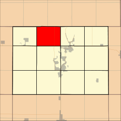
- Diamond Lake Township, Dickinson County, Iowa
-
Diamond Lake Township — Township — Location in Dickinson County Coordinates: 43°28′11″N 95°12′22″W / 43.46972°N 95.20611°WCoordinates: 43°28′11″N 95°12′22″W / 43.46972°N 95.20611°W Country  United States
State  Iowa
IowaCounty Dickinson Area – Total 28.79 sq mi (74.58 km2) – Land 28.26 sq mi (73.19 km2) – Water 0.53 sq mi (1.38 km2) 1.85% Elevation 1,398 ft (426 m) Population (2000) – Total 296 – Density 10.5/sq mi (4/km2) Time zone CST (UTC-6) – Summer (DST) CDT (UTC-5) ZIP codes 51347, 51360 GNIS feature ID 0467715 Diamond Lake Township is one of twelve townships in Dickinson County, Iowa, USA. As of the 2000 census, its population was 296[1].
Contents
Geography
According to the United States Census Bureau, Diamond Lake Township covers an area of 28.79 square miles (74.58 square kilometers); of this, 28.26 square miles (73.19 square kilometers, 98.14 percent) is land and 0.53 square miles (1.38 square kilometers, 1.85 percent) is water.
Unincorporated towns
(This list is based on USGS data and may include former settlements.)
Adjacent townships
- Spirit Lake Township (east)
- Center Grove Township (southeast)
- Lakeville Township (south)
- Excelsior Township (southwest)
- Silver Lake Township (west)
Major highways
Lakes
- Diamond Lake
- Welsh Lake
School districts
- Harris-Lake Park Community School District
- Spirit Lake Community School District
Political districts
- Iowa's 5th congressional district
- State House District 06
- State Senate District 03
References
- United States Census Bureau 2007 TIGER/Line Shapefiles
- United States Board on Geographic Names (GNIS)
- United States National Atlas
External links
Municipalities and communities of Dickinson County, Iowa Cities Arnolds Park | Lake Park | Milford | Okoboji | Orleans | Spirit Lake | Superior | Terril | Wahpeton | West Okoboji
Townships Unincorporated
communityCategories:- Townships in Dickinson County, Iowa
Wikimedia Foundation. 2010.

