- Kandila, Arcadia
-
For other uses, see Kandyla.
Kandila
Κανδήλα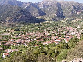
Location 
 Kandila
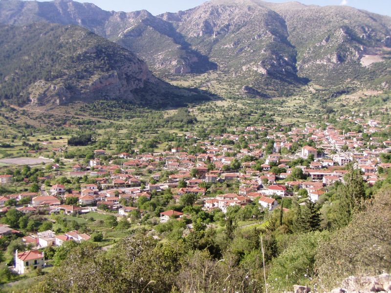
Coordinates 37°46′N 22°23′E / 37.767°N 22.383°ECoordinates: 37°46′N 22°23′E / 37.767°N 22.383°E Government Country: Greece Region: Peloponnese Regional unit: Arcadia Municipality: Tripoli Municipal unit: Levidi Population statistics (as of 2001) Community - Population: 898 Other Time zone: EET/EEST (UTC+2/3) Auto: TP Kandila (Greek: Κανδήλα) is a village and a community in the municipal unit of Levidi, Arcadia, Greece. Situated between the Oligyrtos or Skipiza, Kyllini or Ziria and the Trachy mountains. As of 2001, it had a population of 846 for the village and 898 for the community, which includes the village Diakopi. Not far to the northeast is the Corinthia prefecture.
Contents
Subdivision
- Diakopi Kandilis
Nearest places
- Skoteini, northeast
- Alea, east
- Orchomenos, southwest
- Pyrgou Rema, northwest
- Diakopi, northwest
Population
Year Population village Population municipal district 1981 1,162 - 1991 933 - 2001 846 898 Location
Kandila is located southwest of Kiato and Corinth, WSW of Athens, north of Tripoli, NE of Levidi and southeast of Kalavryta and Patras WNW of Levidi, northwest of Tripoli, ENE of Pyrgos and Olympia and SSE of Patras, it is also 7 km southwest of the GR-33 (Patras - Tripoli).
About Kandila and its history
The village is not visible from far away, with the exception of the Monastery of Virgin Mary, which is built inside a large rock, on the side of the mountain and can be seen as you enter the plateau. In a document from 1467, it was stated that the Fields of Kandila, (the Kandyliotikos Kampos) were farmed and had ample supply of water. The surrounding area had, and continues to have many settlements. Its countryside road system is grid, since most of the farms were created as late as the 19th century and the average farm size is small. After World War II and the Greek Civil War, many houses were renovated, or rebuilt from the ground and many villagers migrated to the US and other parts of the world. Kandila’s main road to the closest town of Levidi was paved in the early 1970s. Electricity, radio, automobiles and farm machinery were introduced in the mid-20th century, television in the late-20th century and computers and internet at the turn of the millennium. In 1997, Kandila and all the surrounding communities were combined under the Kapodistrias law into one jurisdiction, to form the Municipality of Levidi. Kandila residents however, prefer to call the new Municipality Orhomenos, after the ancient city of the Mantinean orhomenos, which is situated half way between Kandila and Levidi.
See also
- List of places in the Arcadia prefecture
External links
- Kandila at the GTP Travel Pages
- This article is mostly based on levidionline.com
References
Municipal unit of Falanthos Municipal unit of Korythio Agiorgitika · Elaiochori · Neochori · Partheni · Steno · ZevgolateioMunicipal unit of Levidi Chotoussa · Dara · Kandila · Kardaras · Komi · Levidi · Limni · Orchomenos · Palaiopyrgos · Panagitsa · VlachernaMunicipal unit of Mantineia Municipal unit of Skyritida Municipal unit of Tegea Alea · Episkopi · Garea · Kamari · Kandalos · Kerasitsa · Lithovounia · Magoula · Manthyrea · Mavriki · Psili Vrysi · Rizes · Stadio · Strigkos · Tzivas · VounoMunicipal unit of Tripoli Agios Vasileios · Agios Konstantinos · Evandro · Makri · Merkovouni · Pallantio · Pelagos · Perthori · Skopi · Thanas · TripoliMunicipal unit of Valtetsi Agriakona · Ampelaki · Arachamites · Asea · Athinaio · Dafni · Dorizas · Kaltezes · Kerastaris · Manaris · Mavrogiannis · Palaiochouni · Paparis · ValtetsiCategories:- Populated places in Arcadia

Wikimedia Foundation. 2010.