- Denneburg
-
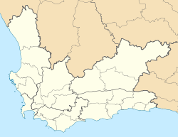
Denneburg Denneburg shown within the Western Cape Coordinates: 33°44′06″S 18°59′02″E / 33.735°S 18.98389°ECoordinates: 33°44′06″S 18°59′02″E / 33.735°S 18.98389°E Country  South Africa
Province Western Cape District municipality Cape Winelands Local municipality Drakenstein Time zone SAST (UTC+2) Postal code Denneburg is a mainly Afrikaaner suburb of Paarl, Western Cape Province, South Africa.
Witzenberg • Drakenstein • Stellenbosch • Breede Valley • Langeberg
Cities and towns Ashton • Bonnievale • Ceres • Chicago • De Doorns • Denneburg • Franschhoek • Gouda • Kayamandi • Klapmuts • Kylemore • Languedoc • McGregor • Montagu • Op-die-Berg • Paarl • Pniel • Prince Alfred Hamlet • Rawsonville • Robertson • Robertsvlei • Rozendal • Saron • Stellenbosch • Touws River • Tulbagh • Wellington • Wemmershoek • Wolseley • Worcester
Categories:- Paarl
- Populated places in the Cape Winelands District Municipality
- Western Cape geography stubs
Wikimedia Foundation. 2010.


