- De Os, Zaandam
-
 Windmill De Os
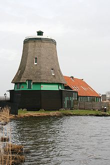
De Os is an oil windmill in the Zaanse Schans, Zaanstad.
Between the saw mills Het Jonge Schaap and Het Klaverblad is the hull of the oil mill De Os. The mill was built in 1663 and is one of the oldest industrial windmills in the Zaan. Until 1916 the mill was operating on wind power. In that year, hood, and wings were removed; the Os was converted a warehouse. The barns are now occupied by the mill and the mill body is restored in recent years.
See also
- De Kat, Zaandam
- De Huisman, Zaandam
- De Zoeker, Zaandam
- De Gekroonde Poelenburg, Zaanse Schans
- Het Jonge Schaap, Zaandam
External links
Windmills in the Netherlands Drenthe Aalden · Barger-Compascuum · Coevorden · Dalen (De Bente · Jan Pol) · De Groeve · De Wijk · Diever · Emmer-Compascuum · Erica · Gasselternijveen · Gieten · Gieterveen · Grolloo · Havelte · Hoogeveen · Makkum · Meppel (De Weert · De Vlijt) · Nijeveen (De Sterrenberg · Lutke's Meule · Tjasker) Noord-Sleen · Norg (De Hoop · Noordenveld) · Oudemolen · Peize · Roderwolde · Rolde · Ruinen · Schoonoord · Sleen · Veenoord · Vledder · Wachtum · Weerdinge · Zeijen (Meesterveen · Bollenveen) · Zuidbarge · Zuidlaren · Zuidwolde
Friesland Achlum · Akkrum · Aldeboarn · Aldtsjerk · Allingawier · Anjum · Augustusga · Bolsward (Tjasker · De Klaver · Lonjé Molen) · Broeksterwoude (De Broekmolen · De Grote Molen) · Buitenpost · Burdaard (De Olifant · De Zwaluw) · Burgwerd (Aylvapoldermolen · De Hiemerter Mole) · Burum · Cornwerd · De Blesse · De Hoeve · Dokkum (De Hoop · Zeldenrust · De Marmeerin) · Dronrijp (De Poelen · Kingmatille · De Hatsumermolen) · Earnewâld · Easterein · Easterlittens · Elsloo · Ezumazijl · Finkum · Formerum · Franeker · Goëngahuizen (De Jansmolen) · De Modderige Bol · Heechheim · Goutum (Kramersmolen · Molen Hoogland) · Grou (De Bird · De Borgmolen · De Haensmolen · Tjasker) · Hallum · Hantum · Hartwerd · Heerenveen · Hogebeintum · Hollum · Holwerd (De Hoop · Miedenmolen) · Húns · Iens · IJlst · Jislum · Joure (De Groene Molen · Penninga's Molen) · Kimswerd · Kollum · Kollumerpomp · Koudum · Langweer · Leeuwarden (Froskepôlemolen, Cammingha-Buurstermolen) · Lekkum · Lollum · Makkinga · Marrum (De Grote Molen · De Kleilânsmole · De Phenix) · Marssum (De Marssumermolen · Terpzigt) · Menaldum (De Kievit · De Rentmeester) · Metslawier · Mildam · Munnekezijl · Nes · Nij Beets · Nijemirdum · Nijetrijne (De Reiger · De Rietvink · Boktjasker) · Nijhuizum · Noordwolde · Oppenhuizen · Oude Leije · Oudega · Paesens · Rinsumageest · Roodkerk · Ryptsjerk · Schalsum · Scharsterberg · Sexbierum · Sleat · Sneek · Johannesga · Stiens (De Hoop · De Kleine Molen · De Stienhuistermolen) · Sumar · Surhuisterveen · Tijnje · Tjerkwerd · Tytsjerk (De Himriksmole · De Lytse Geast) · Tzum (Teetlum · Fatum) · Veenwouden · Vegelingsoord · Vrouwenparochie · Wanswerd · Watena · Wergea (De Hempenserpoldermolen · Paaltjasker) · Westergeest · Wijckel · Winsum · Witmarsum · Wolvega (De Gooyer · Windlust) · Workum (De Nijlânnermolen · Ybema's Molen · Het Heidenschap · De Snip) · Woudsend ('t Lam · De Jager) · Wyns.
Gelderland Aalten · Afferden · Alphen aan de Maas · Alverna · Arnhem (smock mill built in 1960 · post mill built in 1925 · Boktjasker · post mill built in 1946 · De Kroon · Het Fortuyn · Mijn Genoegen · Vorheen · post mill built in 1989 · De Hoop) · Batenburg · Beesd · Beneden-Leeuwen · Bergharen · Beuiningen · Braamt · Breedevoort · Breedenbroek · Bronkhorst · Buren · Culemborg (De Hoop · Johanna) De Heurne · Deil · Dichteren · Didam · Doetinchem (Benninkmolen · De Walmolen) · Ede (De Keetmolen · Concordia) · Ede-Doesburgerbuurt · Elden · Elspeet · Etten · Garderen · Geesteren · Geldermalsen (smock mill · De Bouwing) · Giesbeek · Gorssel · Groesbeek · Haaften · Harderwijk · Harreveld · Harskamp · Hattem · Hellouw (Achterse Molen · 't Veertje · Hooglandse Molen) · Hernen · Herveld · Hurmen · Hulshorst · Hurwenen · Ingen · Kekerdom · Kerkdriel · Kesteren · Klarenbeek · Laag-Keppel · Lienden (De Marsch · De Zwaan) · Linde · Lintelo · Lobith · Loechem-Zwiep · Loil · Lunteren · Maurik · Meddo · Miste · Nederasselt · Nederhemert · Neede · Nieuw-Wehl · Nijkerk-Appel · Nijmegen (Sint Annamolen · Witte Molen) · Nunspeet · Oene · Oldebroek · Oostendorp · Oud-Zevenaar · Overasselt · Putten · Rekken · Rha · Rijswijk · Ruurlo · Silvolde · Stokkum · Terschuur · Terwolde · Twello · Vaassen · Valburg · Varik · Varsseveld · Veessen · Voorst · Vorden (De Hoop · Hackforter Mölen) · Vragender · Waardenbrug (mill built in 1867 · C18th mill) · Wadenoijen · Wageningen · Walderveen · Wapenveld (De Vlijt · De Wielwaal) · Warken · Warnsveld · Wenum · Wijchen · Wilp-Posterenk · Winsen · Winterswijk (Venemansmolen · De Bataaf) · Zeddam (De Volharding · Grafelijke Korenmolen) · Zelhem-Wittebrink · Zevenaar · Zoelen · Zuilichem (smock mill · De Hoop)
Groningen Adorp · Aduard · Bellingwolde · Bourtange · Delfzijl · Den Andel · Den Ham · Eemshaven · Eenrum · Enumatil · Farmsum · Feerwerd · Ganzedijk · Garmerwolde · Garnwerd · Garsthuizen · Glimmen · Grijpskerk (De Kievit · Westerhornermolen) · Haren · Haren-Hoornsedijk · Harkstede · Heiligerglee · Hoeksmeer · Kantens · Kolham · Kropswolde · Laskwerd · Leegkerk · Loppersum · Mensingeweer · Middelstum · Neibert · Nieuw-Scheemda (De Dellen · Westerse Molen) · Nieuwe-Pekela · Niezijl · Noordbroek · Noordbroeksterhamrik · Norddijk · Noorderhoogebrug · Noordhorn · Noordlaren · Oldehove (Aeolus · De Leeuw) · Onderdendam · Onnen · Oude-Pekela · Overschild · Peiterburen · Sebaldeburen · Slochteren (Groote Polder Molen · De Ruiten · Fraeylemamolen) · Spijk · Ten Boer (Bovenrijge · De Widde Meuln) · Ten Post · Ter Haar · Thesinge · Uithuizen · Usquert · Veelerveen · Vierhuizen · Vierverlaten · Visvliet · Vriescheloo · Wedderbergen · Wedderveer · Westerwijtwerd (De Palen · Zeldenrust) · Wetsinge · Winschoten (Molen Dijkstra · Molen Edens) · Winsum (De Ster · De Vriendschap) · Woltersum · Zandeweer · Zeerijp · Zuidwolde ('t Witte Lam · Krimstermolen · Koningslaagte) · Zuurdijk
Limburg Afferden · Baexem · Beegden · Beek · Beesel · Bemelen-Wolfshuis · Gennep · Heijen-Diekendaal · Heythuysen-Areven · Horn (De Hoop · De Welvaart) · Kessel · Maasbracht · Maastricht · Melick · Merselo · Meterik · Nederweert-Kreijel · Nederweert-Roeven · Nuth · Oirsbeek · Ospel · Ottersum · Roggel · Sint Odiliënburg · Stevensweert · Stramproy (Molen van Nijs · Sint Jan) · Swartbroek · Ubachsberg · Urmond · Venray · Sint Oda · Weert-Hushoven · Weert-Keent · Weert-Laar · Weert-Tungelroy
North Brabant Aalst · Almkerk (Oude Doornse Molen · Zandwijkse Molen) · Asten · Bakel · Bavel · Bergeijk · Beugen · Boekel · Borkel · Budel (Janzona · Nooit Gedacht · Zeldenrust) · Den Dungen-Maaskantje · Den Hout · Deurne (Holten's Molen · Maria-Antoinette) · Dieden · Dongen · Drunen · Dussen · Eindhoven-Acht · Etten-Leur · Gassel · Geffen (De Vlijt · Zeldenrust) · Geldrop · Gemert · Goirle (De Visscher · De Wilde) · Halsteren · Hank · Hapert · Haps · Heensche Molen · Heeze · Heusden (Nummer I · Nummer II · Nummer III) · Hilvarenbeek · Hoeven · Hooge Zwaluwe · Huijbergen · Kaatsheuvel (De Couwenbergh · De Eendragt) · Katwijk-Linden · Leur (De Lelie · Zwartenbergse Molen) · Lieshout (De Leest · Vogelenzang) · Liessel · Lith · Luyksgestel · Made · Meerveldhoven · Meeuwen · Megen · Mierlo · Mierlo-Ellenaar · Milheeze · Mill · Moergestel · Nieuw-Borgvliet · Nieuw-Vossemeer · Nieuwkuijk · Nispen · Nistelrode · Nuenen · Oeffelt · Oirschot · Oisterwijk · Oploo · Oss (Nieuwe Leven · Zeldenrust) · Oudemolen · Raamsdonksveer · Ravenstein · Reek · Rijkevoort · Roosendaal (De Hoop · De Twee Gebroeders) · Rosmalen · Rucpen-Bosschenhoofd · Schaijk · Schijndel (Aan de Pegstukken · Catharina) · Sint Agatha · Sint Hubert · Sint Michielsgestel · Sleeuwijk · Someren (De Victor · Den Eveert) · Sprang · Sprundel · Terheijden · Udel · Ulvenhout · Veen · Veldhoven · Veldhoven-Zeelst · Vessem · Vlierden · Volkel · Vorstenbosch · Wanroij · Werkendam · Wijk en Aalburg · Willemsted · Woudrichem · Wouw · Zeeland (Aarssensemolen · Coppensmolen) · Zeeland-Oventje · Zevenburgen · Zundert
North Holland Aalsmeer (De Leeuw · Stommeermolen · De Zwarte Ruiter) · Aartswoud · Akersloot (De Oude Knegt · Noordermolen) · Alkmaar (De Piet · De Eendracht · De Viaan · Geestmolen · Robonsbosmolen) · Alkmaar-Koedikl · Amstelveen · Amsterdam (De Bloem · De Gooiyer · De Otter) · Amsterdam-Buiksloot · Amsterdam-Biekenveldert · Amsterdam-Sloten · Amsterdam Slotermeer (De 1100 Roe · De 1200 Roe) · Amsterdam Zuid-Oost · Ankeveen · Anna Paulowna · Bergen (Damlandermolen · Philisteinse Molen) · Bovenkarspel · Broek op Langdedijk · Burgerbrug (Molen F · Molen Zuider-G) · Burgervlotbrug · Callantsoog · De Waal · Den Oever · Driemond · Edam · Egmond aan den Hoef (Bosmolen · Wimmenumer Molen) · Enkhuizen · Etersheim · Groenveld · Groet-Schoorl · Grootschermer (De Havik · Menningweermolen · post mill) · Haarlem (Schoterveense Molen · De Adriaan) · Haarlem-Penningsveer (De Veer · De Kleine Veer) · Haarlem-Schalkwijk (De Eenhorn · De Kleine Molen) · Haarlem-Vijfhuizen · Heemstede · Heerhugowaard · Heiloo · Hensbroek · Hippolytushoef · Hofddorp · Hoogwoud (De Lastdrager · De Vier Winden) · Katwoude · Koog aan de Zaan · Kortenhoef · Krommeniedijk · Landsmeer · Laren · Medemblik · Middenbeemster · Muiderberg · Neck · Nederhorst den Berg · Nieuwe Niedorp · Obdam (Berkmeermolen · Obdammermolen · Weel & Braken) · Oosterblokker · Oosterend · Oostwoud · Oostzaan · Oterleek · Oude Niedorp · Ouderkerk aan de Amstel · Oudeschild · Oudorp ('t Roode Hert · Strijkmolen B · Strijkmolen C · Strijkmolen D Strijkmolen E Ambachtsmolen) · Rustenburg (Strijkmolen I · Strijkmolen K Strijkmolen L) · Santpoort · Schagerbrug (Molen D · Molen O-D) · Schellinkhout (De Grote Molen · Johan) · Schermerhorn (Bovenmolen E · Bovenmolen G · Ondermolen C · Ondermolen D · Ondermolen K Poldermolen O) · Schoorl (Hagermolen · Kijkduin) · Schoorldam · Sint Maartensvlotbrug (Molen N-G · Molen N-M) · Sint Pancras · Spaarndam-Oost · Spanbroek (De Kaagmolen · De Westerveer) · Stompetoren (Poldermolen D · Poldermolen E · Poldermolen M) · Tuitjenhorn · 't Zand (Molen O-T · Molen P-V) · Uitgeest (Tweede Broekermolen · De Dog · De Dorregeester · De Kat · De Jonge Leeuw) · Ursem · Waarland (Poldermolen · Slootgaardmolen) · Weesp ('t Haantje · De Eendragt · De Vriendschap) · Wervershoof · Westzaan (De Zwaan · De Jonge Dirk · De Schoolmeester · Het Prinsenhof) · Wieringerwaard · Wijdenes · Wogmeer · Wognum · Wormer · Zaandam (Zaanse Schans - De Bonte Hen · De Gekroonde Poelenburg · De Hadel · Het Jonge Schaap · De Huisman · De Kat De Zoeker · Het Klaverblad · De Os) · De Held Jozua · De Ooievaar · Kaatmolen · De Windhond · De Zwarte Kalf · De Kroosduiker) · Zaandijk · Zuidschermer (Paaltjasker · Poldermolen K)
Overijssel Almelo · Ane · Balkbrug · Dalfsen · Denekamp (Nieuwe Molen · Borgelinkmolen) · Deventer · Fleringen · Geesteren · Giethoorn (Noord · Zuid) · Goor · Haaksbergen · Hardenberg · Hasselt · Hellendoorn (De Hoop · De Wippe) · Holten-Dijkerhoek · Kampen · Lattrop · Lettele · Lonneker · Markelo · Marle · Olst · Ommen (De Besthmenermolen · De Konijnenbelt · De Lelie · Den Oordt) · Ootmarsum · Ossenzijl , Radewijk · Reutum · Rijssen · Saasveld · Sint Jansklooster (De Foeke · Monnikenmolen) · Slagharen · Staphorst · Tilligte · Usselo · Vilsteren · Vriezenveen · Welsum · Wijhe · Windesheim · Zalk · Zwolle
Utrecht Abcoude (De Broekzijde Molen · Oostzijdse Molen) · Baambrugge · Breukelen · Bunschoten · Cabauw · Cothen · Elst · Groenekan · IJsselstein · Kockengen (Kockengense Molen · Spengense Molen) · Loenen aan de Vecht (De Hoop · Loenderveense Molen) · Montfoort · Nieuwegein · Nieuwersluis · Nigteviecht · Oud-Zuilen (Buitenwegse Molen · Westbroekse Molen) · Rhenen · Soest · Tienhoven · Utrecht (De Ster · Rijn en Zon) · Veenendaal (De Nieuwe Molen · De Vriendschap) · Vreeland (De Ruiter · Hoekermolen) · Werkhoven · Westbroek · Wijk bij Duurstede · Wilnis · Woerden
Zeeland Aagtekerke · Arnemuiden · Axel · Biervliet · Biggekerke · Borssele · Brouwershaven (De Haan · Windlust) · Burgh-Haamstede · Cadzand · Colijnsplaat (De Oude Molen · Nooit Gedacht) · Domburg · Dreischor · Eindewege · Elkerzee-Scharendijke · Ellemeet · Gapinge · Goes · Grijpskerke · Heinkenszand · Hoedekenskerke · Hoek · Hulst · IJzendijke · Kerkwerve-Moriaanshoofd · Kloetinge · Kloosterzande · Koudekerke · Krabbendijke · Kruiningen · Kuitaart · Meliskerke · Middelburg (De Hoop · De Koning · De Seismolen · Ons Genoegen) · Nieuw- en Sint Joosland · Nieuwerkerk · Nieuwvliet · Nisse · Oost-Souburg · Oosterland · Oostkapelle · Oud Vossemeer · Ovezande · Poortvliet · Retranchement · Rilland-Bath · Scherpenisse · Schoondijke · Serooskerke · 's-Gravenpolder · Sint Annaland (post mill · De Vier Winden) · Sint Maartensdijk · Sint Philipsland · Sluis · Spui · Stavenisse · Tholen · Veere · Vlissingen · Waarde · Wemeldinge (Aeolus · De Hoop ) · Westkapelle · Wissenkerke (De Onderneming · Landzigt) · Wolphaartsdijk · Zierikzee (De Hoop · Den Haas) · Zonnemaire · Zoutelande · Zuidzande
South Holland Aarlanderveen (De Morgenster · Molen Nummer 1 · Molen Nummer 2 · Molen Nummer 3 · Molen Nummer 4) · Abbenbroek · Achthuizen · Alblasserdam (Kortlandse Molen · De Blokweerse Molen) · Alphen aan den Rijn (De Eendracht · Vrouwgeestmolen) · Arkel · Barendrecht · Benthuizen · Bergambacht · Berkel en Rodenrijs · Bleskensgraaf (Tjasker · Hofwegensemolen · Wingerdse Molen) · Bodegraven · Brielle · Delft · Den Bommel · Den Haag (Laakmolen · Nieuwe Veenmolen) · Dirksland · Dordrecht · Geervliet · Giessendam · Goedereede · Gorinchem (De Hoop · Nooit Volmaakt · Oostmolen · Westmolen) · Gouda ('t Slot · De Roode LeeuwHaastrechtse Molen) · Goudriaan · Goudswaard · Groot Ammers (Achterlandse Molen · De Achtkante MolenDe Graaflandse Molen · Gelkense Molen · De Jonge Sofia) · Hazerswoude-Dorp (Gere Molen · Nieuw Leven · Rietveldse Molen · Rooie Wuip) · Hazerswoude-Rijndijk (Groenendijkse Molen · De Rijnenburger) · Hei- en Boeicop · Hellevoetsluis · Herkingen · Hoek van Holland · Hoogmade (Grosmolen · DoesmolenHoogmadese MolenVlietmolen) · Hoornaar (Oudendijkse Molen · Scheiwijkse Molen) · Kaag · Katwijk aan den Rijn · Kinderdijk (Nederwaard Molen Nummer 1 · Nederwaard Molen Nummer 2 · Nederwaard Molen Nummer 3 · Nederwaard Molen Nummer 4 · Nederwaard Molen Nummer 5 · Nederwaard Molen Nummer 6 · Nederwaard Molen Nummer 7 · Nederwaard Molen Nummer 8 · Overwaard Molen Nummer 1 · Overwaard Molen Nummer 2 · Overwaard Molen Nummer 3 · Overwaard Molen Nummer 4 · Overwaard Molen Nummer 5 · Overwaard Molen Nummer 6 · Overwaard Molen Nummer 7 · Overwaard Molen Nummer 8) · Koudekerke aan den Rijn (Hondsdikse Molen · Lagenwaardse Molen) · Krimpen aan den IJssel · Langerak · Leerdam · Leiden (De Heesterboom · De Herder · De Put · De Valk · Kikkermolen · Maredijkmolen · Rodenburgermolen · Stadsmolen) · Leiden-Stevenshof · Leiderdorp (Achthovense Molen · Kalkmolen · Doeshofmolen · Munnikermolen · Zijllaanmolen) · Leidschendam (De Salamander · Bovenmolen · Middenmolen · Ondermolen) · Lexmond · Lisse (Keukenhofmolen · Lageveensemolen · Lisserpoelmolen · Zemelmolen) · Loosduinen · Maasdam (De Hoop · Sint Anthonymolen) · Maasland (De Drie Lelies · Dijkmolen) · Maassluis (De Hoop · De Wippersmolen) · Meerkerk-Den Dool · Mijnsheerenland (De Goede Hoop · Oostmolen) · Moerkapelle · Molenaarsgraaf (De Kerkmolen · De Middelmolen) · Monster · Nieuw-Beijerland · Nieuw-Lekkerland · Nieuwe-Tonge · Nieuwenhoorn · Nieuwerbrug · Nieuwerkerk aan den IJssel · Noordeloos · Nordwijk · Noordwijkerhout · Nootdorp · Oegstgeest · Oostvoorne · Oud-Ade (Rode Molen · Vrouw Vennemolen · Akkersslootmolen) · Oud-Alblas (De Peilmolen · Kooijwijkse Molen) · Ouddorp (De Hoop · De Zwaan) · Oude-Tonge · Oukoop · Piershil · Puttershoek · Rijnsaterwoude (De Geestmolen · Dekkermolen) · Rijpwetering (Adermolen · Blauwe MolenBuurtermolen · Lijkermolen Nummer 1 · Lijkermolen Nummer 2 · Moppermolen · Waterloosmolen) · Rijsoord · Rijswijk · Rockanje · Roelofarendsveen (Googermolen · Veendermolen) · Rotterdam-Charlois · Rotterdam-Delfshaven · Rotterdam-Hillegersbeeg · Rotterdam-Kralingen (De Lelie · De Ster) · Rotterdam-Overschie · Rotterdam-Terbregge · Rozenburg · Schiedam (De Drie Korenblomen · De Nieuwe Palmboom · De Noord · De Vrijheid · De Walvisch · Noletmolen) · Schipluiden (De Korpershoek · Groeneveldse Molen) · 's-Gravendeel · 's-Gravenzande · Sommelsdijk · Spijkenisse · Stad aan 't Haringvliet · Stellendam · Streefkerk (Broekmolen · De Achtkante Molen · De Liefde · Klein Molen · Oude Weteringmolen) · Vlaardingen · Vlist (Bonrepasmolen · De Bachtenaar) · Vorburg · Voorhout · Voorschoten · Warmond (Boterhuismolen · Broekdijkmolen · De KokFaljermolen · Lakermolen · Nieuwe Hofmolen · Zwanburgermolen · Zweilandermolen · 't Poeltje) · Wassenaar (Windlust · Zuidwijksemolen) · Wateringen · Westmaas · Woerdense Verlaat · Zevenhuizen (Eendrachtsmolen · Tweemanspolder Nummer 1 · Tweemanspolder Nummer 2 · Tweemanspolder Nummer 3 · Tweemanspolder Nummer 4) · Zoetermeer · Zoetermeer-Dorp · Zoetermeer-Rijndijk (Barremolen · Grote Molen · Meerburgermolen) · Zuid-Beijerland · Zuidland · Zwamerdam (De Dikke Molen · Steektermolen)
Categories:- Windmills in North Holland
- Populated places in North Holland

Wikimedia Foundation. 2010.