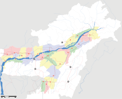
Dalgaon

Dalgaon
Dalgaon
—  town  —
Dalgaon
Location of Dalgaon
in Assam and India
Coordinates 26°34′0″N 92°12′0″E / 26.566667°N 92.2°E / 26.566667; 92.2Coordinates: 26°34′0″N 92°12′0″E / 26.566667°N 92.2°E / 26.566667; 92.2
Country India
State Assam
District(s) Darrang
Time zone IST (UTC+05:30)
Area

Elevation
• Coastline


48 metres (157 ft)
0 kilometres (0 mi)

Dalgaon is a town in Darrang district, Assam, India.

Contents

Geography

It is located at 26°34′0″N 92°12′0″E / 26.566667°N 92.2°E / 26.566667; 92.2 at an elevation of 48 m above MSL.[1]

Location

National Highway 52 passes through Dalgaon.

References

External links


Wikimedia Foundation. 2010.

Игры ⚽ Поможем сделать НИР

Look at other dictionaries:

  • Birpara — is a small commercial town in the centre of the Dooars region of Jalpaiguri district. It is a hub for transportation and trade for the tea garden region of the area.Its co ordinates are:(1) 26 degree 42 min North(2) 89 degree 8 min EastBirpara… …   Wikipedia

  • National Highway 31C (India) — 31C …   Wikipedia

  • Darrang district — দৰং   District   An entrance to Manas National Park, Darrang …   Wikipedia

  • Mangaldoi (Lok Sabha constituency) — Mangaldoi is a Lok Sabha constituency in Assam. Contents 1 Assembly segments 2 Members of Parliament 3 References 4 See also …   Wikipedia

  • Udalguri district — is one of the 27 districts of Assam state in north eastern India. Udalguri town is the headquarters of the district. This district is bounded by Bhutan and West Kameng district of Arunachal Pradesh state in the north, Sonitpur district in the… …   Wikipedia

Share the article and excerpts

Direct link
Do a right-click on the link above
and select “Copy Link”