- D66 road (Croatia)
-
D66 state road
Route information Length: 90.1 km (56.0 mi) Major junctions From:  D400 in Pula
 A9 in Pula interchange
 D401 in Pula
 D64 in Vozilići
 D402 near Brestova
To:  D8 in Matulji
Location Counties: Istria, Primorje-Gorski Kotar Major cities: Pula, Labin, Lovran, Opatija Highway system State roads in Croatia
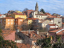 Labin, on the D66 route
 Plomin
 Mošćenička Draga
 Lovran
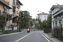 Opatija, D66 route in the city
D66 is a state road connecting A9 motorway[1] with D8 state road in Matulji. D66 road serves as a connection to a number of towns and resorts along the eastern coast of Istria peninsula, including Opatija, Lovran and Ičići, as well as to Brestova ferry port, from which Jadrolinija ferries fly to island of Cres (D100). The northern terminus of the road also provides a link towards Rijeka via D8 state road and to Matulji interchange on A8 motorway[1]. The road is 90.1 km long.[2]
The road, as well as all other state roads in Croatia, is managed and maintained by Hrvatske ceste, a state-owned company.[3]
Traffic volume
Traffic is regularly counted and reported by Hrvatske ceste, operator of the road.[4] Substantial variations between annual (AADT) and summer (ASDT) traffic volumes are attributed to the fact that the road connects a number of summer resorts to Croatian motorway network.
D66 traffic volume Road Counting site AADT ASDT Notes  D66
D662819 Opatija 13,539 17,253 The northernmost traffic counting site on D66. D662814 Medveja 4,705 8,145 D662815 Stepčići 5,700 7,800 Values estimated by HC. The site is located adjacent to the D64 junction. D662817 Raša 2,965 4,612 D663904 Loborika 6,229 8,345 The southernmost traffic counting site on D66, effectively counting traffic between D66 and D400. Road junctions and populated areas
D66 junctions/populated areas Type Slip roads/Notes  D400 to Pula and Pula ferry port.
Southern terminus of the road.Ž5119 to Pomer and Šišan  A9 motorway Pula interchange. D401 to Pula Airport
Loborika - junction with L50169 to Muntić and Nesactium archaeological site L50170 to Muntić Marčana - junction to Duga Uvala Ž5119 to Krnica L50164 to Divšići L50154 to Manjadvorci Ž5100 to Manjadvorci
L50145 to Hreljićito Borinići to Želiski L50153 to Hrboki L50152 to Puntera Barban - junction with Ž5077 to Žminj  D421 to Bršica terminal of the Port of Rijeka
Raša to Krapan to Kapelica Labin:
Ž5081 to Kršan
Ž5103 to Koromacno
Ž5104 to Rabac and Girandella resortŠtrmac - junction with L50187 to Režanci to Vrećari Vozilići:
D64 to Pazin
Ž5172 to Plomin Luka
L50180 to Kožljak resortPlomin D402 to Brestova ferry port providing access to Porozina, Cres (by Jadrolinija)[5] and D100Zagore Brseč - junction with L58064 to Golovik Mošćenička Draga - junction with Ž5082 to Mošćenice to Obrš Donji Kraj Medveja Lovran - junction with Ž5050 to Liganj Ika Ičići - junction with Ž5048 to Veprinac Opatija - junction with Ž5051 to D8 state road Volosko Matulji:
D8 to A8 motorway Matulji interchange and Rijeka
Northern terminus of the road.Sources
- ^ a b "Interchanges of the Y" (in English). May 15, 2010. http://www.bina-istra.com/Default.aspx?sid=1180.
- ^ "Decision on categorization of public roads as state roads, county roads and local roads" (in Croatian). Narodne novine. February 17, 2010. http://narodne-novine.nn.hr/clanci/sluzbeni/2010_02_17_410.html.
- ^ "Public Roads Act" (in Croatian). Narodne novine. December 14, 2004. http://narodne-novine.nn.hr/clanci/sluzbeni/2004_12_180_3130.html.
- ^ "Traffic counting on the roadways of Croatia in 2009 - digest" (in English). Hrvatske ceste. May 1, 2010. http://www.hrvatske-ceste.hr/WEB%20-%20Legislativa/brojenje-prometa/CroDig2009.pdf.
- ^ "Jadrolinija ferry service" (in English). May 11, 2010. http://www.jadrolinija.hr/default.aspx?lang=2.
Categories:- State roads in Croatia
- Istria County
- Primorje-Gorski Kotar County


Wikimedia Foundation. 2010.