- Crystal Block, West Virginia
-
Crystal Block, West Virginia — Unincorporated community — 
 Crystal Block, West Virginia
Coordinates: 37°42′28″N 81°59′18″W / 37.70778°N 81.98833°WCoordinates: 37°42′28″N 81°59′18″W / 37.70778°N 81.98833°W Country United States State West Virginia County Logan Elevation 1,017 ft (310 m) Time zone Eastern (EST) (UTC-5) – Summer (DST) EDT (UTC-4) Area code(s) 304 & 681 GNIS feature ID 1554235[1] Crystal Block is an unincorporated community in Logan County, West Virginia, United States. Crystal Block is located along Island Creek and West Virginia Route 44 9.7 miles (15.6 km) south of Logan.[2]
References
- ^ "Crystal Block". Geographic Names Information System, U.S. Geological Survey. http://geonames.usgs.gov/pls/gnispublic/f?p=gnispq:3:::NO::P3_FID:1554235.
- ^ West Virginia Department of Transportation (2011). Logan County, West Virginia General Highway Map (Map). p. 2. http://gis.wvdot.com/gti/County_Maps/Logan_2_of_2.pdf. Retrieved October 27, 2011.
Municipalities and communities of Logan County, West Virginia City 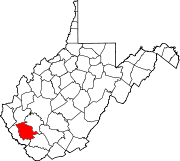
Towns CDPs Unincorporated
communitiesArgyle | Baber | Baisden | Barnabus | Becco | Beebe | Blair | Bradshaw | Braeholm | Claypool | Combs Addition | Cora | Craneco | Crites | Crown | Crystal Block | Dabney | Davin | Dehue | Diamond | Earling | Emmett | Ethel | Gillman Bottom | Greenville | Huff Junction | Lake | Landville | Latrobe | Lorado | Lundale | Lyburn | Melville | Micco | Mineral City | Monitor | Mountain View | Pardee | Peach Creek | Pecks Mill | Phico | Ridgeview | Saunders | Sharples | Shively | Stirrat | Stowe | Sulphur Springs | Superior Bottom | Taplin | Upper Whitman | Whites Addition | Whitman | Wilkinson | Yolyn
Categories:- Populated places in Logan County, West Virginia
- Unincorporated communities in West Virginia
- Metro Valley geography stubs


Wikimedia Foundation. 2010.