- Lee Roy Selmon Expressway
-
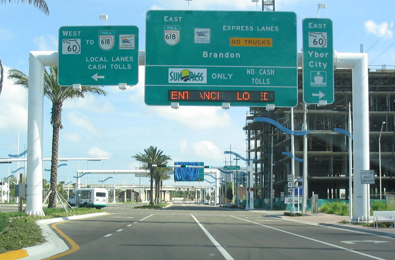
State Road 618
Lee Roy Selmon Expressway Route information Maintained by Tampa-Hillsborough Expressway Authority Length: 14.168 mi[1] (22.801 km) Existed: 1976 – present Major junctions West end: 
 US 92 / SR 600 in South Tampa (local)
Meridian Ave. in Downtown Tampa (express)
 US 41 / SR 599 near Riverview

 US 301 / SR 43 in Riverview
East end: 
 I-75 / SR 93A in Brandon (local)
Town Center Boulevard in Brandon (express)Location Counties: Hillsborough Highway system Florida State and County Roads
Interstate • US • SR (Pre-1945) • Toll • County←  SR 616
SR 656  →
→The Lee Roy Selmon Expressway, originally known as the Southern Crosstown Expressway is a 14.168-mile (22.801 km) all-electronic, limited access toll road in Hillsborough County, Florida, It connects the South Tampa neighborhood near MacDill Air Force Base with Downtown Tampa and the bedroom community of Brandon. The expressway was built in stages, opening between 1976 and 1987, and was named after famed and respected football player and local hero Lee Roy Selmon in 1999.
The expressway was supposed to be part of a multi-expressway system that failed in the 1970s due to heavy local opposition and financial burdens. The original designation for the expressway was State Road 449, but was switched to State Road 618, which remained a hidden designation until the early 2000s, when it began appearing on maps and atlases.
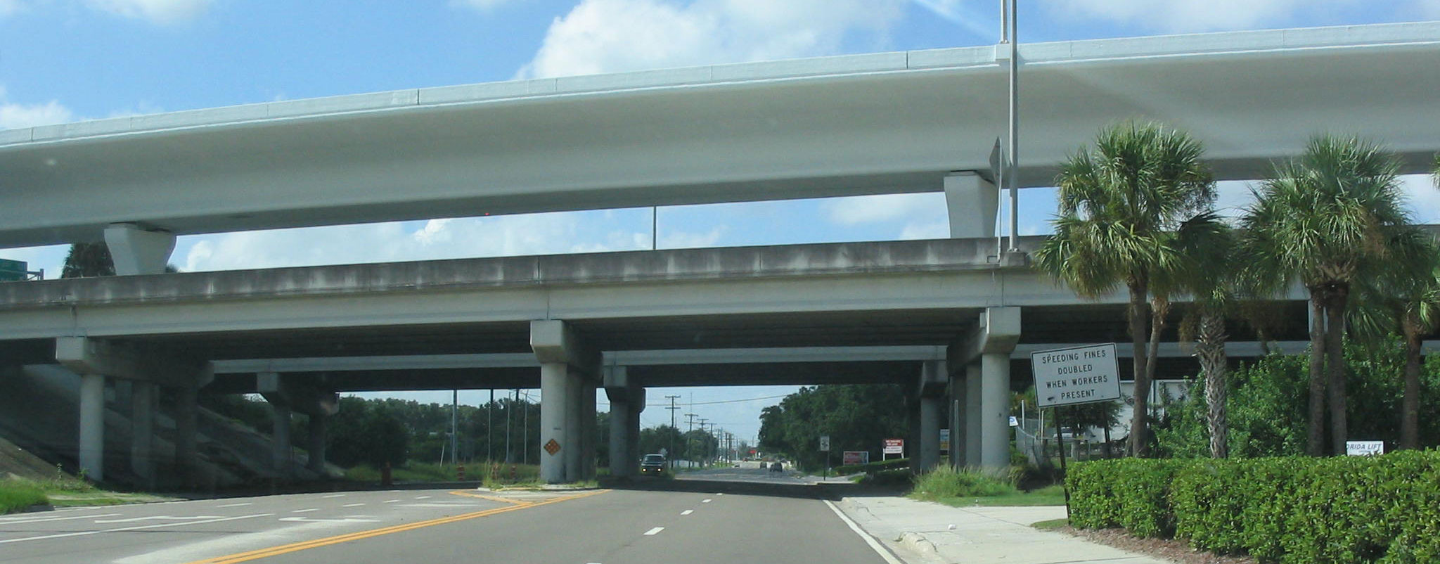
The expressway features an elevated bridge, that became the world's first reversible, all-electronic, elevated express lane project, which opened in 2006, and has the hidden designation of State Road 618A.[1] The entire expressway ended cash collection on September 17th, 2010, going all-electronic for both the express lanes and the main expressway.
Contents
Route description
The tollway begins at an interchange with US Route 92 (Gandy Boulevard) and Dale Mabry Highway north of MacDill Air Force Base. It makes its way north for the first four miles before heading east towards downtown Tampa and ending at a trumpet interchange with I-75 in Brandon.[2]
Elevated Lanes
The lanes begin at Meridian Avenue in downtown Tampa, following the main expressway's path from above in the center median for most of its journey. Just east of the proposed Interstate 4/Selmon Expressway Connector, there is an entryway from the eastbound lanes of the main expressway. Between exits 12 (78th Street) in Tampa and 13 (US Route 301) in Brandon, there is an access points for both directions for switching between the main lanes and express lanes. The express lanes end at Brandon, near Westfield Brandon, east of the I-75 interchange.[3]
Operating hours
- Weekdays
- Westbound (to Downtown): 6 am - 10 am.
- Transitional^: 10 am - 1 pm.
- Eastbound direction (Brandon Pkwy segment) opens at 10:30 am.
- Westbound direction (west of 78th St) closes at 11:30 am.
- Eastbound (to Brandon): 1 pm - 4 am.
- Weekends and Holidays
- Eastbound direction (to Brandon) ONLY^^: 1pm (Friday Afternoon) to 4am (Monday Morning)
^ Denotes transitional operation of the reversible lanes bridge, where the segment between 78th St and downtown Tampa is westbound traffic and the Brandon Pkwy segment east of US 301 is eastbound traffic.
^^ The Reversible Lanes are continuously open in the eastbound direction from Friday afternoon to Monday morning.[4]
- Please Note that these hours are subject to change. Due to ongoing construction from the I-4/Selmon Connector project, the Reversible Lanes may be closed during overnight hours & on weekends.[1]
Open-Road Tolling
The Expressway have no manned toll gates. To accommodate motorists who do not have SunPass transponders (such as those from out of state), the Tampa-Hillsborough Expressway Authority and Florida's Turnpike Enterprise have created the "We Bill You" program (Also known as "Toll-By-Plate").[5]
Each vehicle without a SunPass transponder is photographed and the license plate read. If the license plate number is associated with a "We Bill You" account, that account is used to pay the toll. If there is no account, notification of the toll is mailed to the vehicle's owner; after 30 days, penalties are imposed.
History
The South Crosstown Expressway
See also: Tampa Bay Crosstown Expressway SystemThe Crosstown Expressway is the southern component of what was planned to be a system of expressways throughout the Tampa area from the 1950s to 1970's, but the rest were cancelled by the 1980s due to financial problems, land acquisition and community revolts.[6] The first six miles of the tollway was built in the mid 1970's on a CSX rail line, from the western terminus at Gandy Blvd. at Dale Mabry Highway, making an eastward turn at Platt Street/Willow Avenue, snaking around historic Hyde Park before ending at a 3/4 mile, six lane viaduct, spanning the Hillsborough River in downtown Tampa, ending at Florida Avenue. Ridership was low when it opened in 1976, as people were less willing to drive the toll road when free roads were available nearby. The remaining nine miles of the expressway was built and opened in stages between 1979 and 1987, with the expressway extending to Falkenburg Road in 1983 and connecting to its eastern terminus of I-75 in 1987.[7]
In 1975, a contest was held to determine the logo of the expressway. Only one entry was submitted, a picture of pirate Jose Gaspar with the title "TAMPA CROSSTOWN EXPRESSWAY", all on a blue background. This logo was phased out in the early 2000s. In 2006, an "interim" logo featuring a bridge over a highway reading "Selmon-Crosstown Expressway" was unveiled but was never widely implemented along the expressway. In 2008, a more permanent logo was unveiled, which consists of the FDOT standard "TOLL 618" plates and a "Selmon Crosstown Expressway" logo. This new logo, which replaced the previous Crosstown Expressway logos, reads "SELMON EXPRESSWAY" with downtown Tampa in purple and three ribbons, a yellow one in the middle of two teal ones going towards the city.
In 2001, a city truck equipped with a hydraulic lift slammed into the 34th Street overpass when the vehicle's lift was unknowingly raised. The accident crippled a support beam, which had to be replaced.[citation needed] In 2005, a similar vehicle destroyed the overhead exit sign at Euclid Ave (Exit 2) and over a month passed before a replacement sign (and structure) were installed. Also, over the years there have been a few accidents that made headlines, where vehicles, traveling at high speeds, crashed into one of the toll plazas.
In 2004, the Tampa Hillsborough Expressway Authority accelerated a planned toll hike that would increase the mainline toll plazas by 25 cents and raise the 22nd St Exit tolls to 75 cents from its original date in 2009 to 2007. The toll hike took effect on January 1, 2007, with the hike for the 22nd St ramps going into effect in late June 2006.[citation needed]
On September 17, 2010, cash collection on the Selmon Expressway ended in favor of open road tolling. The original toll plazas were removed and replaced with toll gantries similar to the ones installed on the express lanes, allowing free-flowing movement throughout the tollway. The tollway takes either SunPass or "We Bill You", and customers who do not have either account will be billed later for their use on the expressway.[8][9][10]
The Reversible Elevated Lanes
The reversible lanes, aimed at cutting traffic congestion times, was originally envisioned in 1995 by the Tampa Hillsborough Expressway Authority (THEA) as an innovative idea to increase capacity along the Lee Roy Selmon Expressway from Downtown Tampa to Brandon without acquiring additional right-of-way. Instead, an elevated, three-lane bridge was built over the existing median of the expressway. Planning for the project began around 1995/1996, but final designs/planning were not made until the later 1990s.
 The Lee Roy Selmon Expressway and the Reversible Express Lanes at 78th Street
Construction commenced in 2003 but in 2004, a portion of the elevated bridge collapsed during construction, halting construction for about a year.[citation needed] The segment was repaired and all other piers were reinforced when construction resumed in 2005.
In spring 2005, two realigned sections of the eastbound lanes opened. One section is between 22nd St and 39th St, the other between 78th St and I-75. The at-grade sections of the reversible lanes now follow the old alignments. The Brandon Gateway section of the elevated bridge opened in November 2005 and gained an overwhelmingly positive input by commuters. Thus the bridge was kept open beyond January 2006 (when it was originally scheduled to close for more bridge work) during the evening rush hour.
 The western end of the reversible lanes bridge empties traffic onto the recently reconstructed Meridian Avenue
On July 18, 2006 at 6 am, the reversible lanes opened to westbound morning traffic (only).[11][12] Long lines were formed at the Brandon Gateway well in advance as many anticipated using the new road. However, the scene from news helicopter snapshots showed that only a handful of drivers actually ended up using the new bridge, compared to the number that was expected. These findings may be blamed partly on the lack of advance notification to commuters, the number of commuters who own a SunPass transponder, and an unrelated traffic incident on Ashley Drive in downtown Tampa. Many other questions were raised as a result of the low traffic volume along the reversible lanes.[citation needed] The eastbound direction opened to traffic on August 29, 2006 at 3:30 pm. A "Grand Opening" celebration was held on September 23, 2006, with festivities including a 5k and 10k run across the new bridge.
On November 1, 2006, Florida's Turnpike Enterprise began a pilot program with the THEA, known as "Toll-by-Plate". This program allows occasional commuters to utilize the Reversible Express Lanes through a system of high resolution cameras (at the 78th St barrier checkpoint/gantry) which snap photos of license plates. The commuter is then sent a bill via mail. The THEA reports that over 500 commuters have already signed up for the Toll-by-Plate program since its debut. The program's success so far may lead to future expansion to other tolled thoroughfares in Florida, such as the lower level of the Selmon Expressway, and the Veterans Expressway/Suncoast Parkway.[13] The project was officially completed in 2007 after four years of construction at a cost of $420 million.
Level of service was upgraded from an "F" to an "A" as commuters are now able to travel at full speed, cutting travel time by as much as 60 minutes per day. The elevated lanes project won the prestigious "2007 IBTTA President's Award: Most Innovative Toll Transportation Project in the World," along with 22 awards for engineering excellence and community-friendly design. This modern solution is a prototype for eliminating urban traffic congestion and reducing green house gases. Over 12 million trips on the elevated lanes have been completed with no reported accidents.[citation needed]
In June 2009, a settlement was reached between the THEA, URS, and other parties, regarding the 2004 collapse of the elevated lanes and the lawsuit that followed. The THEA was able to obtain approximately $75 million dollars from the settlement,[14] which will be used to pay off debts and help fund an upcoming widening and rehabilitation project along the downtown Tampa viaduct.[15][16][17]
Future
The Interstate 4/State Road 618 Connector Project
See also: Interstate 4/Selmon Expressway ConnectorThis is a planned connector between the Selmon Expressway and nearby Interstate 4 to the north, designed to help filter hazardous cargo away from Ybor City to the Port of Tampa. The 39th Street interchange (Exit 10) permanently closed on May 13, 2010 to make way for the I-4/Selmon Expressway Connector ramps.[18]
Downtown Viaduct Widening Project
The THEA is currently in the process of finalizing plans to rehabilitate and widen the section of the elevated expressway from Morgan St to 20th St from its existing four lanes, to six lanes. Much of the funding for the $70 million dollar project has been secured, with some of the funds coming from the recent settlement between the THEA and other parties for the 2004 collapse of the elevated express lanes at 50th St. The project is scheduled to begin sometime in 2010.[19]
Contra-flow Study
A study regarding a contra-flow plan for the Selmon during a large-scale evacuation is currently underway.[20] The Hillsborough County EOC and THEA are planning out just how the expressway could be used as an evacuation route. The big limitation of the plans was the reason that the original plans were cancelled is the I-75 trumpet interchange, which narrows to one lane on three of the four ramps to and from the interstate.[21] The current plan, if approved, is as follows.
- Selmon Expressway mainline from Gandy Blvd to Florida Ave: Would be one-way eastbound.
- Selmon Expressway mainline from Florida Ave to I-75: Would be two-way with westbound direction allowing first responders and other emergency personnel quick access to downtown.
- Selmon Expressway reversible express lanes: Would be one-way eastbound for the entire route.
Gandy Boulevard Connector
The THEA is in the planning stages of building a corridor from the current western terminus of the expressway west to the Gandy Bridge via Gandy Boulevard, a project that has been cancelled and revived in recent years.[22][23][24]
Exit list
The entire route is in Hillsborough County.
Location Mile[1] Exit[25] Destinations Notes Tampa 0.040 1 US 92 / SR 600 (Gandy Boulevard) – MacDill AFB, St. PetersburgWestbound exit and eastbound entrance; signed as exits 1A (east) and 1B (west) 1.182 2 Euclid Avenue Westbound exit and eastbound entrance 2.056 3 Bay to Bay Boulevard Westbound exit and eastbound entrance 4.074 4 Willow Avenue – Davis Islands West toll gantry ($1.00 with SunPass, $1.25 with "We Bill You") 4.682 5 Hyde Park Avenue, Plant Avenue – Davis Islands Westbound exit and eastbound entrance 5.153 6A Florida Avenue – Downtown Tampa Eastbound exit and westbound entrance, to Tampa Convention Center 5.153 6B Channelside Drive – Downtown Tampa Eastbound exit and westbound entrance, to St. Pete Times Forum 5.388 7 Morgan Street – Downtown Tampa Westbound exit and eastbound entrance 5.783 8  SR 60 – Downtown Tampa
Westbound exit and eastbound entrance 6.914 9 

 SR 585 north (22nd Street) / US 41 Bus. – Ybor City
Southern Terminus of SR 585 
 I-4 / SR 400 (Selmon Connector)
To be completed in 2013 Express lanes access Eastbound exit only (34th Street) 8.143 10  SR 569 (39th Street)
Closed permanently on May 13, 2010 to make way for the I-4/Selmon Connector[18] 9.053 11 US 41 (Tamiami Trail) / SR 599East toll gantry ($1.50 with SunPass, $1.75 with "We Bill You") 11.067 12 78th Street Eastbound exit and westbound entrance Brandon Express lanes access Westbound exit and eastbound entrance Express lanes access Eastbound exit and westbound entrance 12.911 13 US 301 / SR 4313.713 14 Falkenburg Road Eastbound exit and westbound entrance 14.120 15 I-75 / SR 93A – Naples, OcalaEastbound exit and westbound entrance; signed as exits 15A (south) and 15B (north) 1.000 mi = 1.609 km; 1.000 km = 0.621 mi
Concurrency terminus • Closed/Former • Incomplete access • Unopened- Elevated express lanes
Location Mile[1] Destinations Notes Tampa 0.000 Meridian Street Western terminus 1.880 Eastbound entrance only Toll gantry ($1.50 with SunPass, $1.75 with "We Bill You") Brandon 5.223 Selmon Expressway Ground level Eastbound exit and westbound entrance 7.073 Selmon Expressway Ground level Westbound exit and eastbound entrance 9.056 Town Center Boulevard Eastern terminus, to Westfield Brandon 1.000 mi = 1.609 km; 1.000 km = 0.621 mi
Concurrency terminus • Closed/Former • Incomplete access • UnopenedReferences
- ^ a b c d "Florida Department of Transportation Interchange Report" (PDF). Florida Department of Transportation. 2008-11-24. p. 18. http://www.dot.state.fl.us/planning/statistics/hwydata/interchange.pdf. Retrieved 2009-07-27.
- ^ Google, Inc. Google Maps – overview map of Selmon Expressway (Map). Cartography by Google, Inc. http://maps.google.com/maps?f=d&source=s_d&saddr=W+Gandy+Blvd&daddr=Exit+15B&geocode=FX6fqQEdPAQV-w%3BFRckqgEdH7gX-w&hl=en&mra=ls&sll=27.963987,-82.448423&sspn=0.009419,0.013797&ie=UTF8&t=h&z=12. Retrieved 2010-04-23.
- ^ MapQuest (2010). overview map of Selmon Crosstown Express Lanes (Map). http://www.mapquest.com/mq/9-oZMB_pRq4xV1. Retrieved 2010-4-26.
- ^ "Reversible Elevated Lanes". THEA. http://www.tampa-xway.com/pages.aspx?ID=4280904750.
- ^ "Selmon Expressway Toll by Tag". THEA. http://www.tampa-xway.com/pages.aspx?ID=51409155112.
- ^ Hillsborough's Cancelled Freeways
- ^ Florida @ SouthEastRoads - Florida 618
- ^ Selmon Expressway Converts to All-Electronic Tolling Sept. 17
- ^ Selmon Expressway Prepares for September 2010 Conversion to All-Electronic Tolling
- ^ Kamm, Grayson (January 14, 2009). "Bye bye, toll booths: Selmon Expressway to stop taking cash". 10 Connects. http://www.wtsp.com/news/local/story.aspx?storyid=98077.
- ^ "Crosstown's Brandon link opens Tuesday". St Petersburg Times. July 17, 2006. http://www.sptimes.com/2006/07/17/Hillsborough/Crosstown_s_Brandon_l.shtml.
- ^ "Good news for Hillsborough County commuters". Bay News 9. July 18, 2006. http://www.baynews9.com/content/36/2006/7/18/169343.html?title=Good%20news%20for%20Hillsborough%20County%20commuters.
- ^ "Toll-by-plate off to fast start". Bay News 9. May 9, 2007. http://www.baynews9.com/content/36/2007/5/9/247680.html?title=Toll-by-plate+off+to+fast+start.
- ^ Shopes, Rich (June 30, 2009). "Expressway Authority approves $75 million settlement with insurers in Lee Roy Selmon Crosstown collapse". St. Petersburg Times. http://www.tampabay.com/news/transportation/roads/article1014295.ece.
- ^ "THEA Announces Successful Conclusion of its Mediation with URS and its Insurers for $74,750,000" (pdf) (Press release). Tampa Hillsborough Expressway Authority. June 29, 2009. http://www.tampa-xway.com/images/editor/URSMediation.pdf.
- ^ "Discussion of THEA’s Plan of Finance for the Funds Recovered from the REL Project". THEA. July 13, 2009. http://www.tampa-xway.com/images/editor/Letter%20Preparing%20for%20the%20Future_final%20draft_media.pdf.
- ^ "Preparing for the Future". THEA. July 2009. http://www.tampa-xway.com/images/editor/THEA%20Future%20%5BRead-Only%5D.pdf.
- ^ a b "Selmon Expressway 39th Street Interchange to close permanently on May 13". FDOT. 30 April 2010. http://www.i4.org/news/quick.asp?newsid=239. Retrieved 8 May 2010.
- ^ Salinero, Mike (July 13, 2009). "Settlement from crosstown collapse to fund extra downtown lane". The Tampa Tribune. http://southtampa2.tbo.com/content/2009/jul/13/settlement-crosstown-collapse-fund-extra-downtown-/news/.
- ^ Nahed, Aldo (July 6, 2006). "Selmon a 1-way escape?". St. Petersburg Times. http://www.sptimes.com/2006/07/06/Hillsborough/Selmon_a_1_way_escape.shtml.
- ^ Rosenbaum, S.I. (November 7, 2006). "Exit to Interstate 75 limits hurricane route". St. Petersburg Times. http://www.sptimes.com/2006/11/07/Hillsborough/Exit_to_Interstate_75.shtml.
- ^ Gandy PD&E Study Retrieved 27 Apr 2010
- ^ Thurston, Susan (December 4, 2002). "Gandy plans on hold, for now". St. Petersburg Times. http://www.sptimes.com/2002/12/04/TampaBay/Gandy_plans_on_hold__.shtml.
- ^ Thurston, Susan (October 31, 2002). "Another Tampa Bay Bridge?". St. Petersburg Times. http://www.sptimes.com/2002/10/31/TampaBay/Another_Tampa_Bay_bri.shtml.
- ^ "Selmon Expressway Map". THEA. http://www.tampa-xway.com/images/Plazas.pdf.
External links
- Hillsborough County Expressway Authority Website The Tampa expressway authority that owns Selmon Expressway.
- "Florida 618 (Lee Roy Selmon Expressway)". SoutheastRoads.com. http://www.southeastroads.com/fl-618.html.
Freeways in the Tampa Bay Area Radial Interstate 4 • Interstate 175 • Interstate 375 • Interstate 75 • U.S. Route 19 • Central Pinellas FreewayCircumferential Toll Crosstown Expressway (SR 618) • Veterans Expressway (SR 589) • Suncoast Parkway (SR 589) • Interstate 4 – Selmon Expressway ConnectorArea bridges Courtney Campbell (SR 60) • Bayside (CR 611) • Howard Frankland (I-275) • Gandy (US 92) • Sunshine Skyway (I-275/US 19)Defunct infrastructure Tampa Bay Area Beltway • Northwest Hillsborough Expressway• Tampa Bay Crosstown Expressway SystemCategories:- Toll roads in Florida
- State highways in Florida
- State Roads in Tampa, Florida
- State Roads in Hillsborough County, Florida
- Freeways in the United States
- Weekdays

Wikimedia Foundation. 2010.