- Cowpe
-
Coordinates: 53°40′56″N 2°14′41″W / 53.682147°N 2.244601°W
Cowpe 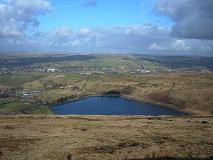

Cowpe Reservoir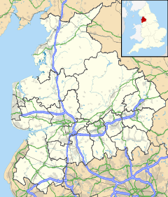
 Cowpe
Cowpe
Cowpe shown within LancashirePopulation 500 OS grid reference SD8420 District Rossendale Shire county Lancashire Region North West Country England Sovereign state United Kingdom Dialling code 01706 Police Lancashire Fire Lancashire Ambulance North West EU Parliament North West England List of places: UK • England • Lancashire Cowpe is a hamlet in Rossendale, Lancashire, England. It lies in the South Pennines, north of Scout Moor Wind Farm, by the path of the Pennine Bridleway. Rawtenstall is to the west, Bacup to the east and Waterfoot to the north. Directly south over Brandwood and Scout Moors, is the town of Rochdale. 'Cowpe' is thought to derive from 'Cow Pastures'.
Cowpe is well renowned for its beautiful scenery, as is the whole of the Rossendale valley, and houses some of the top farms in the area, supplying crop and livestock. The village has a church (Cowpe Sunday School), a pub (The Buck) and a park, designed by residents and opened in 2002 and a B&B (Tippets Farm)http://www.selfcatering-rossendale.co.uk/the-cottage-and-rossendale.html. Cowpe Reservoir is commonly cited by fishermen as a good netting area, and has a large array of footpath routes leading to different areas on the surrounding moors so is very popular with walkers and mountain bikers.[citation needed]There is also a large Christmas tree farm, Lench House Farm, it has many different varieties of Christmas trees and is open from late November until 23/24 December.It is very popular with local people.
Cowpe houses a mixture of terraced houses, cottages, farmhouses, renovated houses and semi detached. They include Austen Buildings (row of The Buck) Brooklands, Ivy Bank, Daisy Bank, Springside, Spring Gardens, Co-operative Buildings, Crag View, Moor View, Bottoms Row, Holmes Cottages and Boarsgreave Lane. Cowpe Road is the main address as it runs throughout the entire village.
Cowpe gained media attention when filming took place for the BBC1 television show Survivors, which used various farms and gardens for filming. The camera crew had to close part of the road for filming because of resident interest. Rawtenstall was also filmed and included in the show.[citation needed]
External links
 Media related to Cowpe at Wikimedia Commons
Towns Villages Hamlets Balladen • Bent Gate • Britannia • Chatterton • Cloughfold • Cowpe • Irwell Vale • Shawforth • Sharneyford • Stacksteads • Strongstry • Stubbins • Turn • WeirCategories:- Villages in Lancashire
- Geography of Rossendale
- Rossendale


Wikimedia Foundation. 2010.