Hail Storm Hill

Hail Storm Hill
Hail Storm Hill

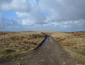
The Pennine Bridleway just to the north of the summit
Elevation 477 m (1,565 ft) [1]
Prominence 244 m (801 ft)
Parent peak Boulsworth Hill
Listing Marilyn
Location
Location Forest of Rossendale, England
Topo map OS Landranger 103
OS grid SD835193

Hail Storm Hill, also known as Cowpe Moss, is the highest point of the Forest of Rossendale, an area of moorland and hill country situated between the West Pennine Moors and the South Pennines. It is wholly within Lancashire, although the county boundary with the Metropolitan Borough of Rochdale passes just a kilometre to the south-east of the summit.

Scout Moor Wind Farm now spans across Hail Storm Hill.

The Forest of Rossendale also contains the Marilyn of Freeholds Top and the summit of Great Hameldon.

Ascents

The shortest route to the summit is from the village of Cowpe just to the north, a journey of just over two miles (3 km) there and back that involves about 600 feet (180 m) of climb. Another option is from the road summit of the A680 at Turf Moor to the south-west, 3.5 miles (5.6 km) long with 500 feet (150 m) of climb. The hill can also be climbed from Rawtenstall to the north-west.

The hill is crossed by three long-distance footpaths: the Pennine Bridleway passes just to the north of the summit, the Rossendale Way goes over the western shoulder and the Rochdale Way passes over Knowl Moor two miles (3 km) to the south.

Coordinates: 53°40′12″N 2°15′04″W / 53.66991°N 2.25122°W / 53.66991; -2.25122

References

  1. ^ Dawson (1992), p.146

Bibliography

  • Dawson, Alan. (1992). The Relative Hills of Britain. Cicerone Press Limited. ISBN 978-1852840686


Wikimedia Foundation. 2010.

Игры ⚽ Поможем решить контрольную работу

Look at other dictionaries:

  • Winter Hill (North West England) — Infobox Mountain Name = Winter Hill Photo = Winter Hill From Blackrod.jpg Caption = Winter Hill from Blackrod. The mast can be seen for many miles around. Elevation = 456 m (1,496 ft) Location = North West England Range = Prominence = 218 m… …   Wikipedia

  • Vinegar Hill, New Zealand — Location Vinegar Hill is a camping ground on the banks of the Rangitikei River within the Putai Ngahere Reserve, and is located on State Highway 54, about 5 km north of Hunterville in the Manawatu Wanganui region of New Zealand, on State Highway… …   Wikipedia

  • October 2010 North American storm complex — The Superstorm of 2010 Satellite image of the United States, while the storm was at peak intensity. Storm type: Cyclone, Blizzard, Derecho, Tornado out …   Wikipedia

  • Maria Hill — For the daughter of the regiment, see Maria Hill, Daughter of the Regiment. Maria Hill Maria Hill. Art by Leinil Francis Yu. Publication information …   Wikipedia

  • Pound Hill — infobox UK place country = England latitude= 51.1220longitude= 0.1486official name= Pound Hill population = 14,700 (2001 data) shire district= Crawley shire county = West Sussex region= South East Englandconstituency westminster= Crawley post… …   Wikipedia

  • Battle of Humbleton Hill — Infobox Military Conflict conflict=Battle of Humbleton Hill caption= partof= date=September 14 1402 place=Wooler, Northumberland, England result=Decisive English Victory combatant1=Scots combatant2=English commander1=Archibald Douglas, 4th Earl… …   Wikipedia

  • Topographic prominence — Prominence redirects here. For other uses, see Prominence (disambiguation). In topography, prominence, also known as autonomous height, relative height, shoulder drop (in North America), or prime factor (in Europe), categorizes the height of the… …   Wikipedia

  • South Pennines — The South Pennines are a region of moorland and hill country in the North of England. They comprise the southern end of the long chain of hills known as the Pennines. They are bounded by the Forest of Rossendale to the west, the Yorkshire Dales… …   Wikipedia

  • Parc éolien de Scout Moor — Vue aérienne du parc éolien Localisation Pays …   Wikipédia en Français

  • Rossendale Valley — Location map Lancashire lat=53.70308 long= 2.28928 width=180 float=right caption= Rossendale Valley shown within Lancashire (gbmapping|SD8123)The Rossendale Valley is part of the Forest of Rossendale , an upland area of North West England,… …   Wikipedia

Share the article and excerpts

Direct link
Do a right-click on the link above
and select “Copy Link”