- Cloughfold
-
Coordinates: 53°41′57″N 2°16′13″W / 53.6991°N 2.2703°W
Cloughfold 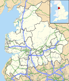
 Cloughfold
Cloughfold shown within LancashireDistrict Rossendale Shire county Lancashire Region North West Country England Sovereign state United Kingdom Post town ROSSENDALE Postcode district BB4 Dialling code 01706 Police Lancashire Fire Lancashire Ambulance North West EU Parliament North West England UK Parliament Rossendale and Darwen List of places: UK • England • Lancashire Cloughfold is a small hamlet in between the towns of Rawtenstall and Waterfoot in Rossendale, Lancashire. There also used to be a railway station there, Clough Fold railway station on the Rawtenstall to Bacup Line, which was opened in 1871 and closed when the line closed in 1966.
Towns Villages Hamlets Balladen • Bent Gate • Britannia • Chatterton • Cloughfold • Cowpe • Irwell Vale • Shawforth • Sharneyford • Stacksteads • Strongstry • Stubbins • Turn • WeirCategories:- Geography of Rossendale
- Villages in Lancashire
- Lancashire geography stubs
- Rossendale

Wikimedia Foundation. 2010.