Mouramba County

Mouramba County
Mouramba
New South Wales
Mouramba NSW.PNG
Location in New South Wales
Lands administrative divisions around Mouramba
Robinson Canbelego Flinders
Booroondarra Mouramba Flinders
Mossgiel Blaxland Flinders

Mouramba County is one of the 141 Cadastral divisions of New South Wales.

Mouramba is believed to be derived from a local Aboriginal word and is the name of nearby Mouramba Station.[1]

Parishes within this county

A full list of parishes found within this county; their current LGA and mapping coordinates to the approximate centre of each location is as follows:

Parish LGA Coordinates
Adams Cobar Shire 31°43′36″S 146°16′36″E / 31.72667°S 146.27667°E / -31.72667; 146.27667 (Adams)
Albyn Cobar Shire 32°06′53″S 145°55′14″E / 32.11472°S 145.92056°E / -32.11472; 145.92056 (Albyn)
Barton Cobar Shire 31°56′52″S 146°04′38″E / 31.94778°S 146.07722°E / -31.94778; 146.07722 (Barton)
Beloura Cobar Shire 32°12′04″S 146°26′11″E / 32.20111°S 146.43639°E / -32.20111; 146.43639 (Beloura)
Blaxland Cobar Shire 32°16′02″S 145°48′44″E / 32.26722°S 145.81222°E / -32.26722; 145.81222 (Blaxland)
Booth Cobar Shire 32°13′48″S 145°45′17″E / 32.23°S 145.75472°E / -32.23; 145.75472 (Booth)
Brigstocke Cobar Shire 32°10′53″S 145°59′35″E / 32.18139°S 145.99306°E / -32.18139; 145.99306 (Brigstocke)
Buppe Cobar Shire 31°39′25″S 146°17′15″E / 31.65694°S 146.2875°E / -31.65694; 146.2875 (Buppe)
Byron Cobar Shire 32°03′41″S 145°51′27″E / 32.06139°S 145.8575°E / -32.06139; 145.8575 (Byron)
Canbelego Cobar Shire 31°49′43″S 146°19′59″E / 31.82861°S 146.33306°E / -31.82861; 146.33306 (Canbelego)
Carlisle Cobar Shire 32°16′03″S 146°01′06″E / 32.2675°S 146.01833°E / -32.2675; 146.01833 (Carlisle)
Chaucer Cobar Shire 32°05′30″S 145°24′24″E / 32.09167°S 145.40667°E / -32.09167; 145.40667 (Chaucer)
Coree Cobar Shire 31°55′36″S 146°17′32″E / 31.92667°S 146.29222°E / -31.92667; 146.29222 (Coree)
Crowl Cobar Shire 32°17′32″S 145°59′36″E / 32.29222°S 145.99333°E / -32.29222; 145.99333 (Crowl)
Devon Cobar Shire 32°01′12″S 146°17′13″E / 32.02°S 146.28694°E / -32.02; 146.28694 (Devon)
Donaldson Cobar Shire 31°47′39″S 145°59′00″E / 31.79417°S 145.9833333°E / -31.79417; 145.9833333 (Donaldson)
Dowling Cobar Shire 32°02′09″S 145°32′11″E / 32.03583°S 145.53639°E / -32.03583; 145.53639 (Dowling)
Dryden Cobar Shire 32°19′00″S 146°15′48″E / 32.3166667°S 146.26333°E / -32.3166667; 146.26333 (Dryden)
Dunstan Cobar Shire 31°55′09″S 146°12′26″E / 31.91917°S 146.20722°E / -31.91917; 146.20722 (Dunstan)
Ellerslie Cobar Shire 32°14′43″S 145°36′37″E / 32.24528°S 145.61028°E / -32.24528; 145.61028 (Ellerslie)
Ellis Cobar Shire 31°58′51″S 146°03′53″E / 31.98083°S 146.06472°E / -31.98083; 146.06472 (Ellis)
Erimeran Cobar Shire 32°16′18″S 146°18′47″E / 32.27167°S 146.31306°E / -32.27167; 146.31306 (Erimeran)
Evans Cobar Shire 32°00′41″S 145°56′39″E / 32.01139°S 145.94417°E / -32.01139; 145.94417 (Evans)
Fisher Cobar Shire 31°43′13″S 146°07′41″E / 31.72028°S 146.12806°E / -31.72028; 146.12806 (Fisher)
Flinders Cobar Shire 31°58′49″S 146°22′34″E / 31.98028°S 146.37611°E / -31.98028; 146.37611 (Flinders)
Fulton Cobar Shire 32°10′48″S 145°29′13″E / 32.18°S 145.48694°E / -32.18; 145.48694 (Fulton)
Gilgunnia Cobar Shire unknown
Goold Cobar Shire 31°55′44″S 145°56′32″E / 31.92889°S 145.94222°E / -31.92889; 145.94222 (Gilgunnia)
Gwynne Cobar Shire 31°51′29″S 145°58′53″E / 31.85806°S 145.98139°E / -31.85806; 145.98139 (Gwynne)
Hartwood Cobar Shire 32°03′04″S 146°22′47″E / 32.05111°S 146.37972°E / -32.05111; 146.37972 (Hartwood)
Hathaway Cobar Shire 32°13′10″S 146°20′56″E / 32.21944°S 146.34889°E / -32.21944; 146.34889 (Hathaway)
Hume Cobar Shire 32°07′54″S 146°04′59″E / 32.13167°S 146.08306°E / -32.13167; 146.08306 (Hume)
Jamieson Cobar Shire 32°08′37″S 146°10′26″E / 32.14361°S 146.17389°E / -32.14361; 146.17389 (Jamieson)
Johnston Cobar Shire 31°50′50″S 146°13′07″E / 31.84722°S 146.21861°E / -31.84722; 146.21861 (Johnston)
Kangerong Cobar Shire 31°56′42″S 145°41′21″E / 31.945°S 145.68917°E / -31.945; 145.68917 (Kangerong)
Keira Cobar Shire 31°53′49″S 146°17′50″E / 31.89694°S 146.29722°E / -31.89694; 146.29722 (Keira)
Kiamba Cobar Shire 32°07′50″S 145°32′05″E / 32.13056°S 145.53472°E / -32.13056; 145.53472 (Kiamba)
Kinchelsea Cobar Shire 32°15′00″S 145°53′27″E / 32.25°S 145.89083°E / -32.25; 145.89083 (Kinchelsea)
Kinnear Cobar Shire 32°14′04″S 146°09′34″E / 32.23444°S 146.15944°E / -32.23444; 146.15944 (Kinnear)
Knox Cobar Shire 32°04′15″S 146°04′36″E / 32.07083°S 146.07667°E / -32.07083; 146.07667 (Knox)
Kruge Cobar Shire 32°20′50″S 146°10′04″E / 32.34722°S 146.16778°E / -32.34722; 146.16778 (Kruge)
Mcgregor Cobar Shire 32°06′22″S 145°50′07″E / 32.10611°S 145.83528°E / -32.10611; 145.83528 (Mcgregor)
Middlesex Cobar Shire 32°19′27″S 146°04′24″E / 32.32417°S 146.07333°E / -32.32417; 146.07333 (Middlesex)
Moothumbool Cobar Shire 32°19′14″S 146°20′59″E / 32.32056°S 146.34972°E / -32.32056; 146.34972 (Moothumbool)
Mossgiel Cobar Shire 32°11′22″S 145°17′25″E / 32.18944°S 145.29028°E / -32.18944; 145.29028 (Mossgiel)
Mouramba Cobar Shire 32°19′54″S 146°27′15″E / 32.33167°S 146.45417°E / -32.33167; 146.45417 (Mouramba)
Nymagee Cobar Shire 31°59′55″S 146°12′16″E / 31.99861°S 146.20444°E / -31.99861; 146.20444 (Nymagee)
Pangee Cobar Shire 32°16′37″S 145°27′02″E / 32.27694°S 145.45056°E / -32.27694; 145.45056 (Pangee)
Priory Plains Cobar Shire 32°05′00″S 146°16′40″E / 32.0833333°S 146.27778°E / -32.0833333; 146.27778 (Priory Plains)
Restdown Cobar Shire 31°45′58″S 146°14′21″E / 31.76611°S 146.23917°E / -31.76611; 146.23917 (Restdown)
Robinson Cobar Shire 32°02′41″S 145°40′00″E / 32.04472°S 145.6666667°E / -32.04472; 145.6666667 (Robinson)
Roset Cobar Shire 32°07′48″S 146°23′01″E / 32.13°S 146.38361°E / -32.13; 146.38361 (Roset)
Scott Cobar Shire 31°51′17″S 146°05′29″E / 31.85472°S 146.09139°E / -31.85472; 146.09139 (Scott)
Shenandoah Cobar Shire 32°00′46″S 145°45′34″E / 32.01278°S 145.75944°E / -32.01278; 145.75944 (Shenandoah)
Teran Cobar Shire 32°22′55″S 146°27′24″E / 32.38194°S 146.45667°E / -32.38194; 146.45667 (Teran)
The Rookery Cobar Shire 31°45′33″S 146°07′13″E / 31.75917°S 146.12028°E / -31.75917; 146.12028 (The Rookery)
Urolie Cobar Shire 32°05′09″S 145°39′17″E / 32.08583°S 145.65472°E / -32.08583; 145.65472 (Urolie)
Walker Cobar Shire 32°09′10″S 146°15′28″E / 32.15278°S 146.25778°E / -32.15278; 146.25778 (Walker)
Wallace Cobar Shire 31°57′32″S 145°51′24″E / 31.95889°S 145.85667°E / -31.95889; 145.85667 (Wallace)
Werlong Cobar Shire 32°16′41″S 145°43′10″E / 32.27806°S 145.71944°E / -32.27806; 145.71944 (Werlong)
Wills Cobar Shire 32°04′06″S 146°11′40″E / 32.06833°S 146.19444°E / -32.06833; 146.19444 (Wills)
Yamma Cobar Shire 32°11′54″S 145°38′16″E / 32.19833°S 145.63778°E / -32.19833; 145.63778 (Yamma)
Yanko Cobar Shire 32°09′12″S 145°44′18″E / 32.15333°S 145.73833°E / -32.15333; 145.73833 (Yanko)
Youyang Cobar Shire unknown

References

  1. ^ Geographical Names Board of NSW

Wikimedia Foundation. 2010.

Игры ⚽ Поможем написать курсовую

Look at other dictionaries:

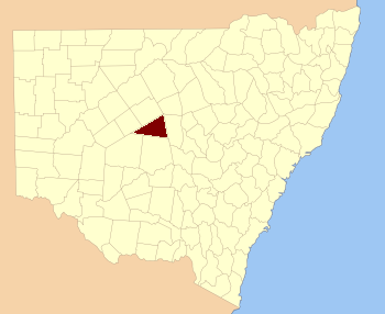
  • Mouramba County, New South Wales — Infobox Australian cadastral name = Mouramba state = New South Wales caption = Location in New South Wales near nw = Robinson near n = Canbelego near ne = Flinders near e = Flinders near se = Flinders near s = Blaxland near sw = Mossgiel near w …   Wikipedia

  • Blaxland County, New South Wales — Infobox Australian cadastral name = Blaxland state = New South Wales caption = Location in New South Wales near nw = Mouramba near n = Mouramba near ne = Flinders near e = Cunningham near se = Gipps near s = Dowling near sw = Franklin near w =… …   Wikipedia

  • Blaxland County — Map of all coordinates from Google Map of all coordinates from Bing Export all coordinates as KML …   Wikipedia

  • Flinders County, New South Wales — Infobox Australian cadastral name = Flinders state = New South Wales caption = Location in New South Wales near nw = Robinson near n = Canbelego near ne = Oxley near e = Kennedy near se = Kennedy near s = Cunningham near sw = Blaxland near w =… …   Wikipedia

  • Mossgiel County, New South Wales — Infobox Australian cadastral name = Mossgiel state = New South Wales caption = Location in New South Wales near nw = Woore near n = Booroondarra near ne = Mouramba near e = Blaxland near se = Franklin near s = Waljeers near sw = Manara near w =… …   Wikipedia

  • Robinson County, New South Wales — Infobox Australian cadastral name = Robinson state = New South Wales caption = Location in New South Wales near nw = Yanda near n = Yanda near ne = Cowper near e = Canbelego near se = Flinders near s = Mouramba near sw = Booroondarra near w =… …   Wikipedia

  • Flinders County — Map of all coordinates from Google Map of all coordinates from Bing Export all coordinates as KML …   Wikipedia

  • Mossgiel County — Map of all coordinates from Google Map of all coordinates from Bing Export all coordinates as KML …   Wikipedia

  • Robinson County — Map of all coordinates from Google Map of all coordinates from Bing Export all coordinates as KML …   Wikipedia

  • Booroondarra County, New South Wales — Infobox Australian cadastral name = Booroondarra state = New South Wales caption = Location in New South Wales near nw = Rankin near n = Yanda near ne = Robinson near e = Mouramba near se = Mossgiel near s = Mossgiel near sw = Woore near w =… …   Wikipedia

Share the article and excerpts

Direct link
Do a right-click on the link above
and select “Copy Link”