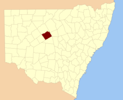
Robinson County

Robinson County
Robinson
New South Wales
Robinson NSW.PNG
Location in New South Wales
Lands administrative divisions around Robinson
Yanda Yanda Cowper
Rankin Robinson Canbelego
Booroondarra Mouramba Flinders

Robinson County is one of the 141 Cadastral divisions of New South Wales. It is centred on Cobar.

Robinson County was named in honour of Sir Hercules George Robert Robinson, First Baron Rosmead (1824-1897).[1]

Parishes within this county

A full list of parishes found within this county; their current LGA and mapping coordinates to the approximate centre of each location is as follows:

Parish LGA Coordinates
Amphitheatre Cobar Shire 31°30′41″S 145°30′49″E / 31.51139°S 145.51361°E / -31.51139; 145.51361 (Amphitheatre)
Balah Cobar Shire 31°33′33″S 145°34′38″E / 31.55917°S 145.57722°E / -31.55917; 145.57722 (Balah)
Baroora Cobar Shire 31°47′27″S 145°45′17″E / 31.79083°S 145.75472°E / -31.79083; 145.75472 (Baroora)
Bee Cobar Shire 31°42′16″S 146°00′07″E / 31.70444°S 146.00194°E / -31.70444; 146.00194 (Bee)
Billagoe Cobar Shire 31°15′26″S 145°51′48″E / 31.25722°S 145.86333°E / -31.25722; 145.86333 (Billagoe)
Booroomugga Cobar Shire 31°16′13″S 146°01′15″E / 31.27028°S 146.02083°E / -31.27028; 146.02083 (Booroomugga)
Booroondarra Cobar Shire 31°12′13″S 145°37′44″E / 31.20361°S 145.62889°E / -31.20361; 145.62889 (Booroondarra)
Buckambool Cobar Shire unknown
Buckwaroon Cobar Shire unknown
Chesney Cobar Shire 31°07′11″S 145°46′49″E / 31.11972°S 145.78028°E / -31.11972; 145.78028 (Chesney)
Cobar Cobar Shire 31°30′21″S 145°49′59″E / 31.50583°S 145.83306°E / -31.50583; 145.83306 (Cobar)
Cohn Cobar Shire 31°32′54″S 146°13′31″E / 31.54833°S 146.22528°E / -31.54833; 146.22528 (Cohn)
Coonumberto Cobar Shire 31°19′00″S 145°44′22″E / 31.3166667°S 145.73944°E / -31.3166667; 145.73944 (Coonumberto)
Coonumberto Cobar Shire 31°19′24″S 145°38′49″E / 31.32333°S 145.64694°E / -31.32333; 145.64694 (Coonumberto)
Coronga Cobar Shire 31°09′54″S 145°57′04″E / 31.165°S 145.95111°E / -31.165; 145.95111 (Coronga)
Coronga Cobar Shire 31°11′48″S 145°59′39″E / 31.19667°S 145.99417°E / -31.19667; 145.99417 (Coronga)
Cuttagullyaroo Cobar Shire 31°16′09″S 145°40′15″E / 31.26917°S 145.67083°E / -31.26917; 145.67083 (Cuttagullyaroo)
Cuttagullyaroo Cobar Shire 31°17′19″S 145°36′04″E / 31.28861°S 145.60111°E / -31.28861; 145.60111 (Cuttagullyaroo)
Davies Cobar Shire 31°20′26″S 145°55′45″E / 31.34056°S 145.92917°E / -31.34056; 145.92917 (Davies)
Gidda Cobar Shire 31°09′21″S 145°43′50″E / 31.15583°S 145.73056°E / -31.15583; 145.73056 (Gidda)
Gidgie Cobar Shire 31°29′41″S 145°22′13″E / 31.49472°S 145.37028°E / -31.49472; 145.37028 (Gidgie)
Grawlin Cobar Shire 31°27′23″S 145°37′26″E / 31.45639°S 145.62389°E / -31.45639; 145.62389 (Grawlin)
Hillston Cobar Shire 31°35′56″S 145°50′09″E / 31.59889°S 145.83583°E / -31.59889; 145.83583 (Hillston)
Hoskins Cobar Shire 31°24′07″S 146°05′55″E / 31.40194°S 146.09861°E / -31.40194; 146.09861 (Hoskins)
Kaloogleguy Cobar Shire 31°24′06″S 145°48′04″E / 31.40167°S 145.80111°E / -31.40167; 145.80111 (Kaloogleguy)
Kaloogleguy Cobar Shire 31°27′24″S 145°46′04″E / 31.45667°S 145.76778°E / -31.45667; 145.76778 (Kaloogleguy)
Kiantharillany Cobar Shire 31°20′54″S 145°36′04″E / 31.34833°S 145.60111°E / -31.34833; 145.60111 (Kiantharillany)
Lambrigg Cobar Shire 31°30′12″S 146°10′24″E / 31.50333°S 146.17333°E / -31.50333; 146.17333 (Lambrigg)
Lerida Cobar Shire 31°42′38″S 145°41′00″E / 31.71056°S 145.6833333°E / -31.71056; 145.6833333 (Lerida)
Linton Cobar Shire 31°29′40″S 145°56′48″E / 31.49444°S 145.94667°E / -31.49444; 145.94667 (Linton)
Louth Cobar Shire 31°18′47″S 145°32′54″E / 31.31306°S 145.54833°E / -31.31306; 145.54833 (Louth)
Louth Cobar Shire 31°21′24″S 145°30′34″E / 31.35667°S 145.50944°E / -31.35667; 145.50944 (Louth)
Mopone Cobar Shire 31°24′24″S 145°52′04″E / 31.40667°S 145.86778°E / -31.40667; 145.86778 (Mopone)
Moquilamba Cobar Shire unknown
Moquilamba Cobar Shire 31°13′39″S 145°46′29″E / 31.2275°S 145.77472°E / -31.2275; 145.77472 (Moquilamba)
Mulga Cobar Shire unknown
Mullimut Cobar Shire 31°22′03″S 145°48′09″E / 31.3675°S 145.8025°E / -31.3675; 145.8025 (Mullimut)
Mumbowanna Cobar Shire 31°19′03″S 145°20′31″E / 31.3175°S 145.34194°E / -31.3175; 145.34194 (Mumbowanna)
Narri Cobar Shire 31°38′12″S 145°58′10″E / 31.63667°S 145.96944°E / -31.63667; 145.96944 (Narri)
Nyngan Cobar Shire 31°24′57″S 145°59′00″E / 31.41583°S 145.9833333°E / -31.41583; 145.9833333 (Nyngan)
Priory Cobar Shire unknown
Rochford Cobar Shire 31°38′27″S 146°07′20″E / 31.64083°S 146.12222°E / -31.64083; 146.12222 (Rochford)
Tambua Cobar Shire 31°22′39″S 145°15′54″E / 31.3775°S 145.265°E / -31.3775; 145.265 (Tambua)
Tindayrey Cobar Shire 31°07′57″S 145°57′12″E / 31.1325°S 145.95333°E / -31.1325; 145.95333 (Tindayrey)
Tindayrey Cobar Shire 31°08′24″S 145°53′29″E / 31.14°S 145.89139°E / -31.14; 145.89139 (Tindayrey)
Toy Cobar Shire 31°28′54″S 145°44′04″E / 31.48167°S 145.73444°E / -31.48167; 145.73444 (Toy)
Walshe Cobar Shire 31°25′45″S 145°25′46″E / 31.42917°S 145.42944°E / -31.42917; 145.42944 (Walshe)
Weltie Cobar Shire 31°33′42″S 145°57′21″E / 31.56167°S 145.95583°E / -31.56167; 145.95583 (Weltie)
Winbar Cobar Shire 31°14′56″S 145°30′45″E / 31.24889°S 145.5125°E / -31.24889; 145.5125 (Winbar)
Yanda Cobar Shire 31°34′51″S 146°04′22″E / 31.58083°S 146.07278°E / -31.58083; 146.07278 (Yanda)

References

  1. ^ Geographical Names Board of NSW

Wikimedia Foundation. 2010.

Игры ⚽ Нужно сделать НИР?

Look at other dictionaries:

  • Robinson County, New South Wales — Infobox Australian cadastral name = Robinson state = New South Wales caption = Location in New South Wales near nw = Yanda near n = Yanda near ne = Cowper near e = Canbelego near se = Flinders near s = Mouramba near sw = Booroondarra near w =… …   Wikipedia

  • Robinson Township — may refer to:Places in the United States: * Robinson Township, Crawford County, Illinois * Robinson Township, Posey County, Indiana * Robinson Township, Brown County, Kansas * Robinson Township, Ottawa County, Michigan * Robinson Township, Kidder …   Wikipedia

  • Robinson (Illinois) — Robinson …   Deutsch Wikipedia

  • County Route 36 (Suffolk County, New York) — County Route 36 South Country Road Route information Maintained by SCDPW Length …   Wikipedia

  • Robinson House — bezeichnet mehrere gleichnamige, im NRHP gelistete, Objekte: Robinson House (Boulder County, Colorado), ID Nr. 86000228 Robinson House (Denver County, Colorado), ID Nr. 03000003 Robinson House (Delaware), ID Nr. 71000225 Robinson House (Illinois) …   Deutsch Wikipedia

  • Robinson (Texas) — Robinson …   Deutsch Wikipedia

  • Robinson Creek — ist der Name mehrerer Flüsse in den Vereinigten Staaten: Robinson Creek (Arkansas), ein Fluss im Polk County, im US Bundesstaat Arkansas Robinson Creek (Illinois), ein Fluss im Hancock County, im US Bundesstaat Illinois Robinson Creek (Kentucky) …   Deutsch Wikipedia

  • Robinson House (Claymont, Delaware) — Robinson House U.S. National Register of Historic Places …   Wikipedia

  • Robinson Township — ist der Name mehrerer Townships in den Vereinigten Staaten: Robinson Township (Illinois) Robinson Township (Indiana) Robinson Township (Kansas) Robinson Township (Michigan) Robinson Township (North Dakota) Robinson Township (Allegheny County,… …   Deutsch Wikipedia

  • Robinson Township, Allegheny County, Pennsylvania — Robinson Township is a township in Allegheny County, Pennsylvania, United States approximately 12 miles west of Pittsburgh. The population was 12,289 at the 2000 census.GeographyRobinson Township is located at coor dms|40|27|28|N|80|7|41|W|city… …   Wikipedia

Share the article and excerpts

Direct link
Do a right-click on the link above
and select “Copy Link”