Mossgiel County

Mossgiel County
Mossgiel
New South Wales
Mossgiel NSW.PNG
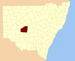
Location in New South Wales
Lands administrative divisions around Mossgiel
Woore Booroondarra Mouramba
Manara Mossgiel Blaxland
Manara Waljeers Franklin

Mossgiel County is one of the 141 Cadastral divisions of New South Wales, Australia. Waverley Creek is the boundary to the south. It includes Trida.

Mossgiel County appears to have been named from the nearby Mossgiel Station.[1]

Parishes within this county

A full list of parishes found within this county; their current LGA and mapping coordinates to the approximate centre of each location is as follows:

Parish LGA Coordinates
Barrigan Cobar Shire 32°21′30″S 145°16′03″E / 32.35833°S 145.2675°E / -32.35833; 145.2675 (Barrigan Parish)
Bennett Cobar Shire 32°36′19″S 145°10′19″E / 32.60528°S 145.17194°E / -32.60528; 145.17194 (Bennett Parish)
Berriganbam Cobar Shire 32°29′04″S 145°07′54″E / 32.48444°S 145.13167°E / -32.48444; 145.13167 (Berriganbam Parish)
Bevan Carrathool Shire 32°56′23″S 145°15′36″E / 32.93972°S 145.26°E / -32.93972; 145.26 (Bevan Parish)
Billabah Cobar Shire 32°39′09″S 145°07′57″E / 32.6525°S 145.1325°E / -32.6525; 145.1325 (Billabah Parish)
Binda Binda Cobar Shire 32°28′32″S 145°18′20″E / 32.47556°S 145.30556°E / -32.47556; 145.30556 (Binda Binda Parish)
Bolaro Cobar Shire 32°18′20″S 145°26′46″E / 32.30556°S 145.44611°E / -32.30556; 145.44611 (Bolaro Parish)
Boobooran Carrathool Shire 33°02′55″S 145°06′32″E / 33.04861°S 145.10889°E / -33.04861; 145.10889 (Boobooran Parish)
Brougham Central Darling Shire 32°35′56″S 144°44′38″E / 32.59889°S 144.74389°E / -32.59889; 144.74389 (Brougham Parish)
Bundamutta Central Darling Shire 32°43′04″S 144°42′37″E / 32.71778°S 144.71028°E / -32.71778; 144.71028 (Bundamutta Parish)
Burrenyinah Cobar Shire 32°35′52″S 145°02′16″E / 32.59778°S 145.03778°E / -32.59778; 145.03778 (Burrenyinah Parish)
Burrinyanni Cobar Shire 32°25′33″S 144°47′14″E / 32.42583°S 144.78722°E / -32.42583; 144.78722 (Burrinyanni Parish)
Calytria South Cobar Shire 32°37′36″S 145°26′31″E / 32.62667°S 145.44194°E / -32.62667; 145.44194 (Calytria South Parish)
Cameron Central Darling Shire 32°47′32″S 144°42′46″E / 32.79222°S 144.71278°E / -32.79222; 144.71278 (Cameron Parish)
Carowra Central Darling Shire 32°33′56″S 144°55′04″E / 32.56556°S 144.91778°E / -32.56556; 144.91778 (Carowra Parish)
Carter Cobar Shire 32°40′51″S 145°23′15″E / 32.68083°S 145.3875°E / -32.68083; 145.3875 (Carter Parish)
Cogie Central Darling Shire 32°59′50″S 145°04′46″E / 32.99722°S 145.07944°E / -32.99722; 145.07944 (Cogie Parish)
Conoble Central Darling Shire 32°49′21″S 144°42′32″E / 32.8225°S 144.70889°E / -32.8225; 144.70889 (Conoble Parish)
Cookenmabourne Central Darling Shire 32°31′09″S 144°48′22″E / 32.51917°S 144.80611°E / -32.51917; 144.80611 (Cookenmabourne Parish)
Coombie Carrathool Shire 32°48′51″S 145°27′07″E / 32.81417°S 145.45194°E / -32.81417; 145.45194 (Coombie Parish)
Eildon Carrathool Shire 32°57′58″S 145°20′35″E / 32.96611°S 145.34306°E / -32.96611; 145.34306 (Eildon Parish)
Elie Central Darling Shire 33°07′53″S 144°38′19″E / 33.13139°S 144.63861°E / -33.13139; 144.63861 (Elie Parish)
Goonaburra Cobar Shire 32°21′00″S 144°55′03″E / 32.35°S 144.9175°E / -32.35; 144.9175 (Goonaburra Parish)
Gunnabonna Central Darling Shire 33°00′25″S 144°50′53″E / 33.00694°S 144.84806°E / -33.00694; 144.84806 (Gunnabonna Parish)
Gunnagia Carrathool Shire 33°04′26″S 145°19′09″E / 33.07389°S 145.31917°E / -33.07389; 145.31917 (Gunnagia Parish)
Haines Carrathool Shire 33°09′31″S 145°14′02″E / 33.15861°S 145.23389°E / -33.15861; 145.23389 (Haines Parish)
Ivanhoe Central Darling Shire 32°53′17″S 144°20′21″E / 32.88806°S 144.33917°E / -32.88806; 144.33917 (Ivanhoe Parish)
Kajuligah Central Darling Shire 32°33′39″S 144°38′00″E / 32.56083°S 144.6333333°E / -32.56083; 144.6333333 (Kajuligah Parish)
Katarah Carrathool Shire 32°43′57″S 145°12′18″E / 32.7325°S 145.205°E / -32.7325; 145.205 (Katarah Parish)
Keewong Cobar Shire 32°18′50″S 145°06′09″E / 32.31389°S 145.1025°E / -32.31389; 145.1025 (Keewong Parish)
Keleela Cobar Shire 32°32′59″S 145°17′35″E / 32.54972°S 145.29306°E / -32.54972; 145.29306 (Keleela Parish)
Kilkoobwal Central Darling Shire 32°56′02″S 144°22′25″E / 32.93389°S 144.37361°E / -32.93389; 144.37361 (Kilkoobwal Parish)
Langcalcal Central Darling Shire 32°57′47″S 144°42′38″E / 32.96306°S 144.71056°E / -32.96306; 144.71056 (Langcalcal Parish)
Largoh Cobar Shire 32°30′50″S 144°57′07″E / 32.51389°S 144.95194°E / -32.51389; 144.95194 (Largoh Parish)
Malagadery Carrathool Shire 33°01′30″S 145°24′58″E / 33.025°S 145.41611°E / -33.025; 145.41611 (Malagadery Parish)
Mallee Carrathool Shire 32°41′42″S 145°17′53″E / 32.695°S 145.29806°E / -32.695; 145.29806 (Mallee Parish)
Manfred Central Darling Shire 32°42′32″S 144°24′31″E / 32.70889°S 144.40861°E / -32.70889; 144.40861 (Manfred Parish)
Marea Central Darling Shire 32°39′38″S 144°34′33″E / 32.66056°S 144.57583°E / -32.66056; 144.57583 (Marea Parish)
Maroopna Carrathool Shire 32°45′16″S 145°27′40″E / 32.75444°S 145.46111°E / -32.75444; 145.46111 (Maroopna Parish)
Marributa Cobar Shire 32°28′52″S 144°39′56″E / 32.48111°S 144.66556°E / -32.48111; 144.66556 (Marributa Parish)
Maybah Central Darling Shire 32°39′51″S 144°24′57″E / 32.66417°S 144.41583°E / -32.66417; 144.41583 (Maybah Parish)
Mimmilinji Central Darling Shire 32°52′58″S 144°28′15″E / 32.88278°S 144.47083°E / -32.88278; 144.47083 (Mimmilinji Parish)
Miparo Central Darling Shire 32°36′39″S 144°25′27″E / 32.61083°S 144.42417°E / -32.61083; 144.42417 (Miparo Parish)
Moolah Cobar Shire 32°42′18″S 145°01′16″E / 32.705°S 145.02111°E / -32.705; 145.02111 (Moolah Parish)
Moongoola Carrathool Shire 32°51′44″S 145°11′06″E / 32.86222°S 145.185°E / -32.86222; 145.185 (Moongoola Parish)
Murringobunni Central Darling Shire 32°46′39″S 144°49′05″E / 32.7775°S 144.81806°E / -32.7775; 144.81806 (Murringobunni Parish)
Murrurah Carrathool Shire 33°06′56″S 144°57′31″E / 33.11556°S 144.95861°E / -33.11556; 144.95861 (Murrurah Parish)
Nerrada Central Darling Shire 32°38′14″S 144°55′45″E / 32.63722°S 144.92917°E / -32.63722; 144.92917 (Nerrada Parish)
Nintie Central Darling Shire 32°48′54″S 145°00′15″E / 32.815°S 145.00417°E / -32.815; 145.00417 (Nintie Parish)
Palmyra Central Darling Shire 33°01′22″S 144°31′21″E / 33.02278°S 144.5225°E / -33.02278; 144.5225 (Palmyra Parish)
Papotoitoi Central Darling Shire 32°55′43″S 144°59′10″E / 32.92861°S 144.98611°E / -32.92861; 144.98611 (Papotoitoi Parish)
Pingunnia Cobar Shire 32°27′14″S 144°49′16″E / 32.45389°S 144.82111°E / -32.45389; 144.82111 (Pingunnia Parish)
Pittenweem Central Darling Shire 33°07′47″S 144°32′34″E / 33.12972°S 144.54278°E / -33.12972; 144.54278 (Pittenweem Parish)
Plevna Central Darling Shire 33°09′07″S 144°42′57″E / 33.15194°S 144.71583°E / -33.15194; 144.71583 (Plevna Parish)
Scholefield Carrathool Shire 33°07′17″S 145°03′08″E / 33.12139°S 145.05222°E / -33.12139; 145.05222 (Scholefield Parish)
St Monans Central Darling Shire 33°03′21″S 144°41′39″E / 33.05583°S 144.69417°E / -33.05583; 144.69417 (St Monans Parish)
Tholloolaboy Carrathool Shire 33°03′22″S 144°51′12″E / 33.05611°S 144.85333°E / -33.05611; 144.85333 (Tholloolaboy Parish)
Thoolamagoogi Central Darling Shire 32°38′04″S 144°35′39″E / 32.63444°S 144.59417°E / -32.63444; 144.59417 (Thoolamagoogi Parish)
Tiarri Central Darling Shire 32°44′43″S 145°00′51″E / 32.74528°S 145.01417°E / -32.74528; 145.01417 (Tiarri Parish)
Tibara Central Darling Shire 32°51′44″S 144°53′38″E / 32.86222°S 144.89389°E / -32.86222; 144.89389 (Tibara Parish)
Ticehurst Central Darling Shire 32°47′25″S 144°24′33″E / 32.79028°S 144.40917°E / -32.79028; 144.40917 (Ticehurst Parish)
Tinkoh Central Darling Shire 32°46′33″S 145°06′47″E / 32.77583°S 145.11306°E / -32.77583; 145.11306 (Tinkoh Parish)
Toorak Central Darling Shire 33°05′13″S 144°19′07″E / 33.08694°S 144.31861°E / -33.08694; 144.31861 (Toorak Parish)
Trewalla Central Darling Shire 33°05′36″S 144°26′09″E / 33.09333°S 144.43583°E / -33.09333; 144.43583 (Trewalla Parish)
Trida Central Darling Shire 32°58′45″S 144°58′41″E / 32.97917°S 144.97806°E / -32.97917; 144.97806 (Trida Parish)
Umphelby Carrathool Shire 32°47′42″S 145°16′56″E / 32.795°S 145.28222°E / -32.795; 145.28222 (Umphelby Parish)
Waiko Central Darling Shire 32°46′16″S 144°31′47″E / 32.77111°S 144.52972°E / -32.77111; 144.52972 (Waiko Parish)
Wallangery Central Darling Shire 32°31′37″S 144°31′41″E / 32.52694°S 144.52806°E / -32.52694; 144.52806 (Wallangery Parish)
Wanga Carrathool Shire 32°52′54″S 145°21′21″E / 32.88167°S 145.35583°E / -32.88167; 145.35583 (Wanga Parish)
Wangaroa Carrathool Shire 32°58′06″S 145°10′08″E / 32.96833°S 145.16889°E / -32.96833; 145.16889 (Wangaroa Parish)
Warranary Carrathool Shire 33°10′22″S 145°08′04″E / 33.17278°S 145.13444°E / -33.17278; 145.13444 (Warranary Parish)
Warrenitchie Central Darling Shire 33°01′40″S 144°21′32″E / 33.02778°S 144.35889°E / -33.02778; 144.35889 (Warrenitchie Parish)
Wee Elwah Carrathool Shire 33°05′30″S 145°12′32″E / 33.09167°S 145.20889°E / -33.09167; 145.20889 (Wee Elwah Parish)
Weejugalah Central Darling Shire 33°02′17″S 144°59′17″E / 33.03806°S 144.98806°E / -33.03806; 144.98806 (Weejugalah Parish)
Weenigoota Cobar Shire 32°24′52″S 145°08′35″E / 32.41444°S 145.14306°E / -32.41444; 145.14306 (Weenigoota Parish)
Weeribinyah Central Darling Shire 32°54′08″S 144°36′30″E / 32.90222°S 144.60833°E / -32.90222; 144.60833 (Weeribinyah Parish)
Wharparoo Central Darling Shire 32°50′00″S 144°36′31″E / 32.8333333°S 144.60861°E / -32.8333333; 144.60861 (Wharparoo Parish)
Whittingham Carrathool Shire 33°10′23″S 145°22′38″E / 33.17306°S 145.37722°E / -33.17306; 145.37722 (Whittingham Parish)
Willingerie Central Darling Shire 32°42′33″S 144°49′46″E / 32.70917°S 144.82944°E / -32.70917; 144.82944 (Willingerie Parish)
Winderima Cobar Shire 32°35′23″S 145°18′16″E / 32.58972°S 145.30444°E / -32.58972; 145.30444 (Winderima Parish)
Woore Cobar Shire 32°18′22″S 144°57′53″E / 32.30611°S 144.96472°E / -32.30611; 144.96472 (Woore Parish)
Wooroola Carrathool Shire 33°07′39″S 144°50′30″E / 33.1275°S 144.84167°E / -33.1275; 144.84167 (Wooroola Parish)
Yallock Cobar Shire 32°26′55″S 144°57′45″E / 32.44861°S 144.9625°E / -32.44861; 144.9625 (Yallock Parish)
Yaradah Central Darling Shire 32°56′09″S 144°43′36″E / 32.93583°S 144.72667°E / -32.93583; 144.72667 (Yaradah Parish)
Yathong Cobar Shire unknown
Youyang Cobar Shire unknown
Yugaruree Cobar Shire 32°17′15″S 145°16′40″E / 32.2875°S 145.27778°E / -32.2875; 145.27778 (Yugaruree Parish)

References

  1. ^ Geographical Names Board of NSW

Wikimedia Foundation. 2010.

Игры ⚽ Нужен реферат?

Look at other dictionaries:

  • Mossgiel County, New South Wales — Infobox Australian cadastral name = Mossgiel state = New South Wales caption = Location in New South Wales near nw = Woore near n = Booroondarra near ne = Mouramba near e = Blaxland near se = Franklin near s = Waljeers near sw = Manara near w =… …   Wikipedia

  • Mossgiel — Koordinaten 55° 32′ N, 4° 24′ W …   Deutsch Wikipedia

  • Waljeers County — Map of all coordinates from Google Map of all coordinates from Bing Export all coordinates as KML …   Wikipedia

  • Mouramba County — Map of all coordinates from Google Map of all coordinates from Bing Export all coordinates as KML …   Wikipedia

  • Franklin County, New South Wales — Infobox Australian cadastral name = Franklin state = New South Wales caption = Location in New South Wales near nw = Mossgiel near n = Mossgiel near ne = Blaxland near e = Dowling near se = Nicholson near s = Nicholson near sw = Waljeers near w …   Wikipedia

  • Woore County, New South Wales — Infobox Australian cadastral name = Woore state = New South Wales caption = Location in New South Wales near nw = Werunda near n = Rankin near ne = Booroondarra near e = Mossgiel near se = Mossgiel near s = Manara near sw = Livingstone near w =… …   Wikipedia

  • Woore County — Map of all coordinates from Google Map of all coordinates from Bing Export all coordinates as KML …   Wikipedia

  • Waljeers County, New South Wales — Infobox Australian cadastral name = Waljeers state = New South Wales caption = Location in New South Wales near nw = Manara near n = Mossgiel near ne = Mossgiel near e = Franklin near se = Nicholson near s = Waradgery near sw = Caira near w =… …   Wikipedia

  • Booroondarra County, New South Wales — Infobox Australian cadastral name = Booroondarra state = New South Wales caption = Location in New South Wales near nw = Rankin near n = Yanda near ne = Robinson near e = Mouramba near se = Mossgiel near s = Mossgiel near sw = Woore near w =… …   Wikipedia

  • Manara County, New South Wales — Infobox Australian cadastral name = Manara state = New South Wales caption = Location in New South Wales near nw = Livingstone near n = Woore near ne = Mossgiel near e = Mossgiel near se = Waljeers near s = Kilfera near sw = Wentworth near w =… …   Wikipedia

Share the article and excerpts

Direct link
Do a right-click on the link above
and select “Copy Link”