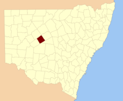
Booroondarra County

Booroondarra County
Booroondarra
New South Wales
Booroondarra NSW.PNG
Location in New South Wales
Lands administrative divisions around Booroondarra
Rankin Yanda Robinson
Rankin Booroondarra Mouramba
Woore Mossgiel Mossgiel

Booroondarra County is one of the 141 Cadastral divisions of New South Wales.

Booroondarra is believed to be derived from a local Aboriginal word.[1]

Parishes within this county

A full list of parishes found within this county; their current LGA and mapping coordinates to the approximate centre of each location is as follows:

Parish LGA Coordinates
Albinia Cobar Shire 31°59′00″S 145°06′41″E / 31.9833333°S 145.11139°E / -31.9833333; 145.11139 (Albinia Parish)
Barneto Cobar Shire 31°38′09″S 144°52′49″E / 31.63583°S 144.88028°E / -31.63583; 144.88028 (Barneto Parish)
Benkanyah Cobar Shire 31°51′40″S 145°22′04″E / 31.86111°S 145.36778°E / -31.86111; 145.36778 (Benkanyah Parish)
Bingunyah Cobar Shire 31°43′00″S 144°39′32″E / 31.7166667°S 144.65889°E / -31.7166667; 144.65889 (Bingunyah Parish)
Bluff Cobar Shire 31°34′58″S 145°14′09″E / 31.58278°S 145.23583°E / -31.58278; 145.23583 (Bluff Parish)
Bulgoo Cobar Shire unknown
Congrou Cobar Shire 31°45′44″S 145°23′46″E / 31.76222°S 145.39611°E / -31.76222; 145.39611 (Congrou Parish)
Cookamilerie Cobar Shire 31°48′54″S 144°47′49″E / 31.815°S 144.79694°E / -31.815; 144.79694 (Cookamilerie Parish)
Coolibah Cobar Shire 31°25′20″S 145°11′52″E / 31.42222°S 145.19778°E / -31.42222; 145.19778 (Coolibah Parish)
Cowl Cobar Shire 31°48′33″S 145°12′36″E / 31.80917°S 145.21°E / -31.80917; 145.21 (Cowl Parish)
Cuckaroo Cobar Shire 31°37′37″S 145°10′04″E / 31.62694°S 145.16778°E / -31.62694; 145.16778 (Cuckaroo Parish)
Cultogerie Cobar Shire 31°56′00″S 145°04′06″E / 31.9333333°S 145.06833°E / -31.9333333; 145.06833 (Cultogerie Parish)
Euchara Cobar Shire 31°33′24″S 144°58′04″E / 31.55667°S 144.96778°E / -31.55667; 144.96778 (Euchara Parish)
Euchara Cobar Shire 31°34′28″S 144°57′19″E / 31.57444°S 144.95528°E / -31.57444; 144.95528 (Euchara Parish)
Finley Cobar Shire 31°59′57″S 144°56′33″E / 31.99917°S 144.9425°E / -31.99917; 144.9425 (Finley Parish)
Goreetabah Cobar Shire 31°57′20″S 145°17′36″E / 31.95556°S 145.29333°E / -31.95556; 145.29333 (Goreetabah Parish)
Jumbah Cobar Shire 31°41′55″S 145°04′16″E / 31.69861°S 145.07111°E / -31.69861; 145.07111 (Jumbah Parish)
Kallerakay Cobar Shire 31°58′01″S 145°26′27″E / 31.96694°S 145.44083°E / -31.96694; 145.44083 (Kallerakay Parish)
Kelena Cobar Shire unknown
Lammunnia Cobar Shire 31°47′21″S 145°07′07″E / 31.78917°S 145.11861°E / -31.78917; 145.11861 (Lammunnia Parish)
Makunagoona Cobar Shire 32°08′13″S 145°12′16″E / 32.13694°S 145.20444°E / -32.13694; 145.20444 (Makunagoona Parish)
Meadows Cobar Shire 31°44′32″S 145°16′15″E / 31.74222°S 145.27083°E / -31.74222; 145.27083 (Meadows Parish)
Moolamanda Cobar Shire 32°06′51″S 145°02′33″E / 32.11417°S 145.0425°E / -32.11417; 145.0425 (Moolamanda Parish)
Mulchara Cobar Shire 31°47′01″S 144°56′02″E / 31.78361°S 144.93389°E / -31.78361; 144.93389 (Mulchara Parish)
Mulga Downs Cobar Shire 31°29′20″S 145°05′45″E / 31.48889°S 145.09583°E / -31.48889; 145.09583 (Mulga Downs Parish)
Paddington Cobar Shire 32°09′00″S 145°06′36″E / 32.15°S 145.11°E / -32.15; 145.11 (Paddington Parish)
Patutyah Cobar Shire 32°02′25″S 145°09′50″E / 32.04028°S 145.16389°E / -32.04028; 145.16389 (Patutyah Parish)
Pulputah Cobar Shire 32°02′24″S 145°19′58″E / 32.04°S 145.33278°E / -32.04; 145.33278 (Pulputah Parish)
Rankin Cobar Shire 31°36′54″S 144°58′04″E / 31.615°S 144.96778°E / -31.615; 144.96778 (Rankin Parish)
Rankin Cobar Shire 31°37′01″S 145°00′15″E / 31.61694°S 145.00417°E / -31.61694; 145.00417 (Rankin Parish)
Springfield Cobar Shire 31°38′32″S 145°23′43″E / 31.64222°S 145.39528°E / -31.64222; 145.39528 (Springfield Parish)
Tiltargara Cobar Shire 31°51′54″S 144°53′04″E / 31.865°S 144.88444°E / -31.865; 144.88444 (Tiltargara Parish)
Tiltargara Cobar Shire 31°53′46″S 144°52′05″E / 31.89611°S 144.86806°E / -31.89611; 144.86806 (Tiltargara Parish)
Turner Cobar Shire unknown
Wampunnia Cobar Shire 31°52′39″S 145°01′06″E / 31.8775°S 145.01833°E / -31.8775; 145.01833 (Wampunnia Parish)
Winnini Cobar Shire 32°03′41″S 144°59′38″E / 32.06139°S 144.99389°E / -32.06139; 144.99389 (Winnini Parish)
Winta Cobar Shire 31°37′30″S 144°51′10″E / 31.625°S 144.85278°E / -31.625; 144.85278 (Winta Parish)
Wynduc Cobar Shire 31°41′04″S 145°19′35″E / 31.68444°S 145.32639°E / -31.68444; 145.32639 (Wynduc Parish)

References


Wikimedia Foundation. 2010.

Игры ⚽ Поможем написать реферат

Look at other dictionaries:

  • Booroondarra County, New South Wales — Infobox Australian cadastral name = Booroondarra state = New South Wales caption = Location in New South Wales near nw = Rankin near n = Yanda near ne = Robinson near e = Mouramba near se = Mossgiel near s = Mossgiel near sw = Woore near w =… …   Wikipedia

  • Robinson County — Map of all coordinates from Google Map of all coordinates from Bing Export all coordinates as KML …   Wikipedia

  • Mossgiel County, New South Wales — Infobox Australian cadastral name = Mossgiel state = New South Wales caption = Location in New South Wales near nw = Woore near n = Booroondarra near ne = Mouramba near e = Blaxland near se = Franklin near s = Waljeers near sw = Manara near w =… …   Wikipedia

  • Rankin County, New South Wales — Infobox Australian cadastral name = Rankin state = New South Wales caption = Location in New South Wales near nw = Killara near n = Landsborough near ne = Yanda near e = Robinson near se = Booroondarra near s = Woore near sw = Werunda near w =… …   Wikipedia

  • Robinson County, New South Wales — Infobox Australian cadastral name = Robinson state = New South Wales caption = Location in New South Wales near nw = Yanda near n = Yanda near ne = Cowper near e = Canbelego near se = Flinders near s = Mouramba near sw = Booroondarra near w =… …   Wikipedia

  • Woore County, New South Wales — Infobox Australian cadastral name = Woore state = New South Wales caption = Location in New South Wales near nw = Werunda near n = Rankin near ne = Booroondarra near e = Mossgiel near se = Mossgiel near s = Manara near sw = Livingstone near w =… …   Wikipedia

  • Mossgiel County — Map of all coordinates from Google Map of all coordinates from Bing Export all coordinates as KML …   Wikipedia

  • Woore County — Map of all coordinates from Google Map of all coordinates from Bing Export all coordinates as KML …   Wikipedia

  • Mouramba County, New South Wales — Infobox Australian cadastral name = Mouramba state = New South Wales caption = Location in New South Wales near nw = Robinson near n = Canbelego near ne = Flinders near e = Flinders near se = Flinders near s = Blaxland near sw = Mossgiel near w …   Wikipedia

  • Yanda County, New South Wales — Infobox Australian cadastral name = Yanda state = New South Wales caption = Location in New South Wales near nw = Landsborough near n = Gunderbooka near ne = Cowper near e = Cowper near se = Robinson near s = Booroondarra near sw = Rankin near w …   Wikipedia

Share the article and excerpts

Direct link
Do a right-click on the link above
and select “Copy Link”