California County Routes in zone R

California County Routes in zone R
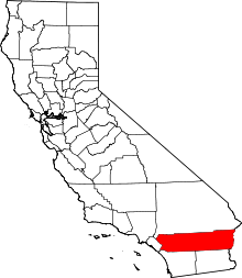
All county highways in zone R lie within Riverside County.

In the California Route Marker Program, which designates county routes in California, only two highways exist in the "R" zone: CR R2 and CR R3. Both of these routes are in Riverside County.

Contents


R2

County Route R2
Location: Riverside County
Length: 11.26 mi[1] (18.12 km)
Existed: 1964–present[1]

County Route R2 is also known as Kaiser Road. Its southern end is SR 177 and its north end is at Eagle Mountain, a modern day ghost town.

The route was defined in 1964, and has not been altered since then.

R3

County Route R3
Location: Riverside County
Length: 23.45 mi[1] (37.74 km)
Existed: 1966 or 1973–present[1]

County Route R3 is also known by several other names along its route. Portions of the highway are called Sage Road, Cactus Valley Road, and State Street. Its southern end is SR 79 and its north end is SR 74.

At its north end in Hemet, it provides a major transportation route.

Historic information conflicts as to the date the route was defined. Some information indicates the highway was created in 1966, although other sources give a commissioning date of 1973.[1]

References

  1. ^ a b c d e Faigin, Daniel. "County Routes 'R'". California Highways. http://cahighways.org/countyr.html. Retrieved 2010-02-18. 

Wikimedia Foundation. 2010.

Игры ⚽ Нужно решить контрольную?

Look at other dictionaries:

  • California County Routes in zone S — There are 34 routes assigned to the S zone of the California Route Marker Program, which designates county routes in California. The S zone includes county highways lying in the counties of Imperial, Orange, Riverside, San Diego, and Santa… …   Wikipedia

  • California County Routes in zone G — There are 21 routes assigned to the G zone of the California Route Marker Program, which designates county routes in California. The G zone includes county highways lying in the counties of Monterey, San Benito, San Luis Obispo, Santa Clara, and… …   Wikipedia

  • California County Routes in zone J — There are 45 routes assigned to the J zone of the California Route Marker Program, which designates county routes in California. The J zone includes county highways lying in the counties of Alameda, Calaveras, Contra Costa, Fresno, Kern, Inyo,… …   Wikipedia

  • California County Routes in zone A — There are 27 routes assigned to the A zone of the California Route Marker Program, which designates county routes in California. The A zone includes county highways lying in the counties of Lassen, Plumas, Shasta, Siskiyou, and Tehama. Contents 1 …   Wikipedia

  • California County Routes in zone E — There are 21 routes assigned to the E zone of the California Route Marker Program, which designates county routes in California. The E zone includes county highways lying in the counties of Alpine, Amador, Butte, Calaveras, El Dorado, Placer,… …   Wikipedia

  • California County Routes in zone N — There are 9 routes assigned to the N zone of the California Route Marker Program, which designates county routes in California. The N zone includes county highways lying in the counties of Los Angeles and Orange. Contents 1 N1 2 N2 3 N3 4 …   Wikipedia

  • County routes in California — Example of a California county route shield. System information Notes: All classes of state numbered highways are generally state maintained. Hig …   Wikipedia

  • California State Route 13 — CA 13 redirects here. For the congressional district, see California s 13th congressional district. For the original Sign Route 13, see California State Route 13 (1934). State Route 13 …   Wikipedia

  • Portal:California — Wikipedia portals: Culture Geography Health History Mathematics Natural sciences People Philosophy Religion Society Technology …   Wikipedia

  • Contra Costa County, California — County of Contra Costa   County   The west face of Mount Diablo, the most notable …   Wikipedia

Share the article and excerpts

Direct link
Do a right-click on the link above
and select “Copy Link”