- List of county routes in Niagara County, New York (902–907)
-
There are four county highways with designations above 900 in the Niagara County, New York county road system. None of these designations are signed as Niagara County does not sign their highways, and thus are better known by their accompanying road name. The locations of the four routes are scattered across the county.
Three of the four routes—County Route 902 (Lower Mountain Road in the town of Cambria), County Route 903 (Hinman Road in the town of Lockport), and County Route 905 (Griswold Road in the town of Royalton)—do not overlap other routes. The fourth, County Route 907, is a designation for a 5-mile (8.0 km) long county-maintained portion of New York State Route 18F alongside the Niagara River. All four highways were assigned by 1996 and are marked on New York State Department of Transportation digital raster quadrangles.
County Route 907 is the highest three-digit county route in terms of designation in the state of New York. Overall, it is the second-highest numbered county route in the state; only County Route 1345 in the Saratoga County town of Mechanicville has a higher designation.
Contents
Route 902
County Route 902 Location: {{{location}}} Length: 3.99 mi[1] (6.42 km) County Route 902 (CR 902) is an east–west county highway located in the town of Cambria and the town of Lockport. The route heads eastward along Lower Mountain Road, continued by County Route 116 and New York State Route 425 along its right-of-way to the west. The western terminus is at an intersection with NY 425, and the eastern terminus is located at the Lockport city line, where the Route 902 designation ends, and the maintenance along Lower Mountain Road becomes County Route 125. However, the Niagara County Department of Economic Development marks on their September 2008 map, that the highway continues as County Route 128, not 125.[2]
Route 902 begins at an intersection with NY 425 in the community of Cambria Center. The highway progresses eastward through the rural segments of Niagara County, passing fields and residential homes along the stretch of Lower Mountain Road. The route intersects with Green Road, where it forks, with CR 902 heading to the northeast, and County Route 64 (Thrall Road) heading to the southeast.[1]
CR 902 continues through the same regions, intersecting with Plank Road and Budd Road, which head northward out of Cambria. The highway heads eastward, entering the community of Hickory Corners, where it intersects with New York State Route 93, which is co-designated by the Niagara County Highway Department as County Route 114. The route heads straight eastward for a short distance, until turns to the southeast, intersecting with Leete Road. After a short distance, Route 902 intersects with Gothic Hill Road and crosses the line into the city of Lockport, where it continues as County Route 125 (Niagara Street Extension).[1]
Route 902 was assigned by 1996 along the alignment of Lower Mountain Road by 1996 and has remained intact on its alignment since.[3][4][1]
Location Mile[1] Destinations Notes Cambria Center 0.00  NY 425
Western terminus of CR 902 Cambria–Lockport town line 3.44  NY 93
NY 93Town of Lockport 3.99 CR 125 Eastern terminus of CR 902 1.000 mi = 1.609 km; 1.000 km = 0.621 mi Route 903
County Route 903 Location: {{{location}}} Length: 1.58 mi[5] (2.54 km) County Route 903 (CR 903) is a short east–west county highway in the town and city of Lockport. The route is assigned along the alignment of Hinman Road from an intersection with New York State Route 270 (Campbell Boulevard) at the Cambria–Lockport town line to the Lockport city line, where it continues as a city-maintained road. Route 903 does not intersect with any other side streets along its county-maintained alignment.
CR 903 begins at an intersection with NY 270 (Campbell Boulevard) near the Cambria–Lockport town line. The highway progresses eastward, passing through the area of residential homes and large fields. To the north, New York State Route 31 and NY 93 parallel on a wide highway. There is a short curve to the northeast, passing through the fields in the area. Route 903 continues its way eastward, passing a large farm and crossing the line into the city of Lockport, as Route 902 does, a few miles to the north.[5]
The route was assigned by 1996 along the Hinman Avenue alignment.[4] The route has remained there since.[5]
Location Mile[5] Destinations Notes Cambria–Lockport town line 0.00  NY 270
Western terminus of CR 903 Town of Lockport 1.58 Lockport city line Eastern terminus of CR 903 1.000 mi = 1.609 km; 1.000 km = 0.621 mi Route 905
County Route 905 Location: {{{location}}} Length: 5.02 mi[6] (8.08 km) County Route 905 (CR 905) is a north–south county-maintained highway entirely in the town of Royalton. The route is known locally in Royalton as Griswold Street. Route 905 progresses its way northward from its southern terminus, New York State Route 77 (Lewiston Road) to its northern terminus at an intersection with NY 31 (Telegraph Road) and County Route 139 (Carmen Road). CR 139 is the continuation of Griswold Road northward. The only intersections in between are with local roads in Royalton.
Route 905 begins at an intersection with NY 77, known locally as Lewiston Road, in the town of Royalton, north of the Tonawanda State Wildlife Management Area. The route heads northward from Lewiston Road, passing through fields for a long distance. There is an intersection with Johnson Road, passing more fields, and intersecting with Chestnut Ridge Road, a county-maintained roadway.[6]
CR 905 continues northward, passing through more local fields. There is an intersection with Graham Road, a local road in the area. The surroundings change little for several miles, and the highway progresses northward, intersecting with Mountain Road, a local road. A short distance later, County Route 905 terminates at an intersection with NY 33 (Telegraph Road) in Royalton. CR 139 (Carmen Road) continues ahead.[6]
Griswold Road was originally named over one of the original fifteen overseers of highways in Royalton, New York, John Griswold. Griswold had just moved into Royalton area in 1816, which was named Griswold Street.[7] Route 905 was assigned by 1996 along the Griswold Street alignment, according to the New York State Department of Transportation Digital Raster Quadrangles.[8] The highway has remained intact since.[6]
Location Mile[6] Destinations Notes Royalton 0.00  NY 77
NY 77Southern terminus of CR 905 5.02  NY 31 / CR 139
Northern terminus of CR 905 1.000 mi = 1.609 km; 1.000 km = 0.621 mi Route 907
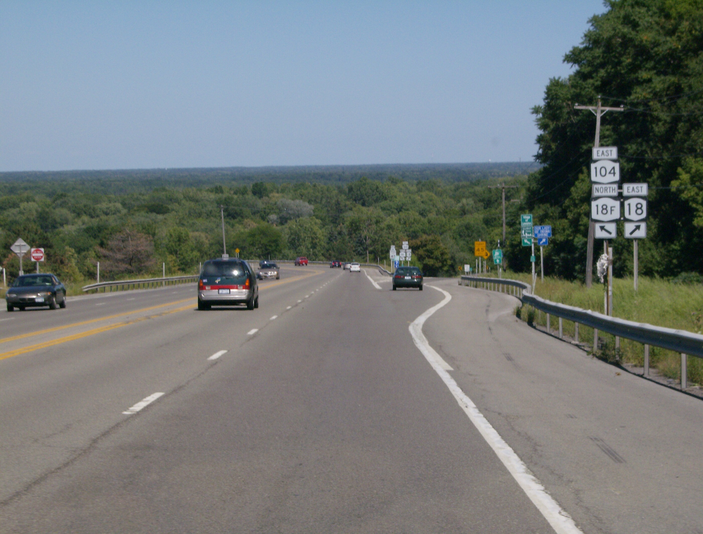
County Route 907 Location: {{{location}}} Length: 5.68 mi[9] (9.14 km)  Erroneous NY 18F signage on NY 104. County Route 907 starts just over a mile from this interchange
County Route 907 (CR 907) is a north–south county-maintained highway that overlaps the New York State Department of Transportation-assigned New York State Route 18F, the only suffixed route of New York State Route 18 in existence. Route 907 is assigned from the intersection with Center Street, the southern continuation of NY 18F, to Jackson Street in Youngstown. The highway is 5.68 miles (9.14 km) long, with one major intersection, Pletcher Road.
Route 907 was assigned onto the county-maintained segment of NY 18F by 1996, with it remaining intact since.[10][9]
Location Mile[9] Destinations Notes Village of Lewiston 0.00 Center Street Southern terminus of CR 907; NY 18F continues east on Center Street Town of Lewiston 2.17 Pletcher Road To Robert Moses State Parkway and NY 18 (Creek Road) Youngstown 5.68 Jackson Street Northern terminus of CR 907; NY 18F continues northeast on Jackson Street 1.000 mi = 1.609 km; 1.000 km = 0.621 mi See also
References
- ^ a b c d e Yahoo Maps. Overview map of Niagara County Route 902 (Map). Cartography by NAVTEQ Incorporated. http://maps.yahoo.com/#mvt=m&lat=43.17774&lon=-78.790912&zoom=15&q1=43.177521%2C-78.819108&q2=43.182466%2C-78.744178. Retrieved March 3, 2009.
- ^ Niagara County, New York Department of Economic Development (September 2008). Niagara County, New York Master Numbering Map (Map). Cartography by Niagara County, New York Department of Economic Development.
- ^ New York State Department of Transportation (1996). Cambria Digital Raster Quadrangle (Map). 1:24,000. http://www.nysgis.state.ny.us/gisdata/quads/drg24/dotpreview/index.cfm?code=o8. Retrieved January 22, 2010.
- ^ a b New York State Department of Transportation (1996). Lockport Digital Raster Quadrangle (Map). 1:24,000. http://www.nysgis.state.ny.us/gisdata/quads/drg24/dotpreview/index.cfm?code=o9. Retrieved January 22, 2010.
- ^ a b c d Yahoo Maps. Overview map of Niagara County Route 903 (Map). Cartography by NAVTEQ Incorporated. http://maps.yahoo.com/#mvt=h&lat=43.144626&lon=-78.745405&zoom=16&q1=43.144548%2C-78.754653&q2=43.146458%2C-78.724226. Retrieved March 3, 2009.
- ^ a b c d e Yahoo Maps. Overview map of Niagara County Route 905 (Map). Cartography by NAVTEQ Incorporated. http://maps.yahoo.com/#mvt=m&lat=43.144693&lon=-78.492313&zoom=14&q1=43.205362%2C-78.490597&q2=43.133107%2C-78.495918. Retrieved March 4, 2009.
- ^ Pool, William (1897). Landmarks of Niagara County, New York. D. Mason and Publishers Company.
- ^ New York State Department of Transportation (1996). Medina Digital Raster Quadrangle (Map). 1:24,000. http://www.nysgis.state.ny.us/gisdata/quads/drg24/dotpreview/index.cfm?code=o11. Retrieved January 22, 2010.
- ^ a b c Yahoo Maps (2009). Overview map of Niagara County Route 907 (Map). Cartography by NAVTEQ Incorporated. http://maps.yahoo.com/#mvt=h&lat=43.25282&lon=-79.043395&zoom=16&q1=43.172954%2C-79.044468&q2=43.250429%2C-79.049875. Retrieved March 4, 2009.
- ^ New York State Department of Transportation (1996). Lewiston Digital Raster Quadrangle (Map). 1:24,000. http://www.nysgis.state.ny.us/gisdata/quads/drg24/dotpreview/index.cfm?code=o6. Retrieved January 22, 2010.
External links
Niagara (NY) County Routes 1–25 • 26–50 • 51–75 • 76–100 • 101–125 • 126–141 • 271 • 902–907 Categories:- Infobox road small transclusions without location
- County routes in Niagara County, New York
Wikimedia Foundation. 2010.