- Cortlandt Street (IRT Broadway
-
Cortlandt Street New York City Subway rapid transit station 
Station destruction caused by September 11, 2001 attacksStation statistics Address Cortlandt Street & Greenwich Street
New York, NY 10280Borough Manhattan Locale Financial District Coordinates 40°42′36″N 74°00′43″W / 40.710°N 74.012°WCoordinates: 40°42′36″N 74°00′43″W / 40.710°N 74.012°W Division A (IRT) Line IRT Broadway – Seventh Avenue Line Services None (closed) Connection PATH: NWK–WTC and HOB–WTC at World Trade Center Structure Underground Platforms 2 side platforms Tracks 2 Other information Opened July 1, 1918 Closed September 11, 2001 (temporary) Former/other names Cortlandt Street – World Trade Center Station succession Next north Chambers Street: no regular service Next south Rector Street: no regular service Cortlandt Street (also known as Cortlandt Street – World Trade Center) is a temporarily closed station on the IRT Broadway – Seventh Avenue Line of the New York City Subway. The station was demolished after being heavily damaged during the September 11, 2001 attacks.
Contents
History
The station was named after Cortlandt Street, which formerly ran east and west from Broadway to West Street in Lower Manhattan, nicknamed "Radio Row" because of the many electronics dealers on the street. The station was constructed and opened in 1918. It was originally located under Cortlandt and Greenwich streets, with a standard two side platform layout with two tracks and mosaic decorations by Squire J. Vickers depicting a ship.
In 1965, Cortlandt Street west of Church Street was demolished to create the superblock of the World Trade Center. The station, with entrances at Vesey Street and inside the World Trade Center concourse, was not particularly close to the remaining block of Cortlandt Street. The old tiling and mosaics disappeared and were replaced with 1970s-style tiles. One of the Vickers mosaics is preserved in the New York Transit Museum.
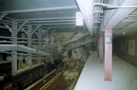
The station and the surrounding subway tunnels were severely damaged in the September 11, 2001 terrorist attacks, resulting in the closure of the line south of Chambers Street. The steel I-beams of the station were crumpled and the station roof began to collapse. To quickly restore service to Rector Street and South Ferry stations to the south, workers demolished the remainder of the station and built walls where the platforms used to be. The tunnels and tracks in the vicinity of the station site as it traversed Ground Zero were entirely rebuilt. The line reopened on September 15, 2002, with trains bypassing the site of the Cortlandt Street station.[1]
In October 2008, the Port Authority stated in a report that it had come to an agreement with the MTA on reconstructing the Cortlandt St. station. The MTA would pay the Port Authority to rebuild the station as part of the Port Authority's World Trade Center Transportation Hub contract, in order to make the construction process more efficient. The Port Authority was set to complete underpinning and excavation under the tunnel structure by the second quarter of 2010, and start basic construction of the station during the 3rd quarter. Station finishes would start during the second quarter of 2011.[2]
In the 2010 – 2nd Quarter report, the Port Authority confirmed that excavation under the tunnel structure of the World Trade Center site was nearly complete, and that construction of the Cortlandt St. station would begin during the 3rd quarter of 2010.[3] As of September 2011, work continues on the station mezzanine and platforms, and the first partial opening is expected to take place in 2014.[4] The tracks are walled off for the protection of the workers while the construction is underway.
References
- ^ Kennedy, Randy. "Tunnel Vision; With Station's Reopening, Even Commuters Smile", The New York Times, September 17, 2002. Accessed October 6, 2007.
- ^ World Trade Center Report: A Roadmap Forward - Port Authority of New York and New Jersey, October 2008, page 50
- ^ World Trade Center Quarterly Report - 2nd Quarter 2010, pp. 9, 11
- ^ Jennifer Fermino (September 7, 2011). "Cortlandt Street station comes back to life". New York Post. http://www.nypost.com/p/news/local/manhattan/cortlandt_street_station_comes_back_oFPvXKNr9bRu0F9ECeuAwM. Retrieved September 11, 2011.
Further reading
- Lee Stokey. Subway Ceramics : A History and Iconography. 1994. ISBN 978-0-9635486-1-0
External links
 External videos
Ten Years Later: MTA Reflects on 9/11, Metropolitan Transportation Authority; September 7, 2011; 4:21 YouTube video clip - nycsubway.org — IRT West Side Line: Cortlandt Street-World Trade Center
Categories:- Defunct New York City Subway stations
- IRT Broadway – Seventh Avenue Line stations
- New York City Subway stations in Manhattan
- September 11 attacks
- Railway stations opened in 1918
Wikimedia Foundation. 2010.