- Coode Island
-
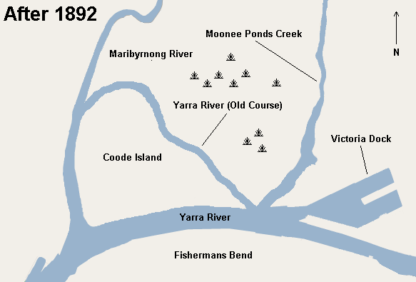
 Map of Coode Island after a channel was cut in 1886, diverting the flow of the Yarra River, creating Coode Island.
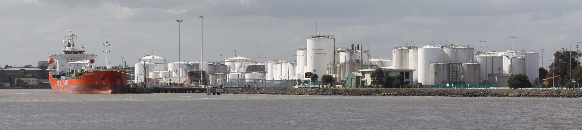
 Coode Island viewed from the junction of the Yarra and Maribyrnong Rivers
Coode Island, was an island at the convergence of the Yarra and Maribyrnong Rivers, 4km west of central Melbourne, Australia. Today the low-lying land is part of the Port of Melbourne, site of Swanson and Appleton Docks and their associated container storage and rail yards, as well as a number of chemical storage facilities.
History
Originally extensive low-lying wetlands, the area became an island after a channel was dug to shorten the length of the Yarra River in 1886.[1][2] A shipping canal was constructed to the south of the existing course of the river through Fishermans Bend, to allow access from the Port of Melbourne to Yarraville. The boundaries were the canal on the south, the Maribyrnong River on the west and the Yarra River on the north and east. Once formed, the island became an industrial area of 97 hectares. The island was named after Sir John Coode, an English harbour engineer who was engaged by the Melbourne Harbour Trust to select the optimum route for the canal as part of the Port of Melbourne. The former course of the Yarra River was slowly filled in over the years, along with the associated swamps, and by the mid 20th century, Coode Island was no longer a true island, although the name remained.
By 1909 the area was being used as an animal quarantine station and after 1915 as a sanatorium for victims of bubonic plague and other contagious diseases.[3] By the 1920s the area was inhabited by hermits living in huts and abandoned ships. In 1927 the Larkin Aircraft Supply Company had set up operations on the island, including a factory and aerodrome,[4][5] which was used until World War II.
In 1960 the area began being used for the storage of petrochemicals. In 1968 the Swanson Dock container terminal was constructed on the south side of the former island, which reduced the size of Coode Island.
On 21 August 1991 St Elmos Fire ignited one of the storage tanks, resulting in the Coode Island explosion. 8.5 million litres of chemicals burned, creating a toxic cloud over nearby residential suburbs, which was fortunately dispersed by high winds.[6][7][8][9][10]
Proposals were made to move the facility to Point Lillias near Geelong,[11][12] but environmental and Aboriginal heritage concerns thwarted the plans. In 2000 the Bracks Government announced that Coode Island would be the site of Victoria's major petrochemical storage facility, with six companies leasing the facility from the Melbourne Port Authority.
See also
References
- ^ "History of the port". Port of Melbourne. http://www.portofmelbourne.com/community/maritimeheritage/porthistory.asp. Retrieved 2008-08-21.
- ^ GREAT HARBOUR PROJECTED. How the Port Has Grown. Sir John Coode's Great Part. The Argus (Melbourne, Vic.) 9 September 1926
- ^ The Sydney Morning Herald (NSW), 3 July 1915, COODE ISLAND. MELBOURNE, Friday. The Premier (Sir Alexander Peacock) stated to-day that it had been decided to sell the quarantine station at Coode Island to the military authorities. It is proposed that returning soldiers suffering from contagious diseases, such as typhoid fever and measles, shall be accommodated at Coode Island.
- ^ "Larkin, Herbert Joseph (1894 - 1972)". Australian Dictionary of Biography Online. http://www.adb.online.anu.edu.au/biogs/A090676b.htm. Retrieved 2008-08-21.
- ^ COODE ISLAND AIR PORT., The Argus (Melbourne, Vic.) 14 September 1927 p 23 Article Illustrated
- ^ "Coode Island, Melbourne, Vic: Explosion & Chemical Fire". Emergency Management Australia. http://www.ema.gov.au/ema/emadisasters.nsf/54273a46a9c753b3ca256d0900180220/dce42babf5210b47ca256d3300057b6e?OpenDocument. Retrieved 2008-08-21.[dead link]
- ^ Chemical accidents at Coode Island:1991 Aug 21-22, Fire and explosion in tanks at Terminals, involving acrylonitrile (acts like cyanide on the human body), Benzene (effects nervous system and causes leukaemia), Phenol and Methyl Ethyl Ketone. Residents and workers evacuated from the immediate vicinity; other residents told to stay inside. Smoke plume carried as far as Fern Tree Gully and covered the Central Business District. A number of firefighters were injured., (The Hazardous Materials Action Group)HAZMAG
- ^ Coode Island Review Panel, FINAL REPORT, Prepared for the Victorian Government, March 1992, Coode Island Community Consultative Committee
- ^ Don’t Mention It - Coode Island and Environmental Disclosure Strategies in the Australian Chemicals Industry, By Kathy Gibson, Senior Lecturer in Accounting & Professor Gary O’Donovan, University of Tasmania, Edwards School of Business
- ^ ABC News 1991 with Clive Hale, story Coode Island chemical fire Melbourne Video on Youtube
- ^ "About Coode Island". Coode Island Community Consultative Committee. http://www.ciccc.org/coodeisland.htm. Retrieved 2008-08-21.
- ^ The Point Lillias Chemical Storage Facility:A proposed chemical storage facility for Victoria
Coordinates: 37°48′55″S 144°54′26″E / 37.81528°S 144.90722°E
Categories:- Islands of Victoria (Australia)
- Explosions in Australia
Wikimedia Foundation. 2010.