Connolly Drive

Connolly Drive
Connolly Drive
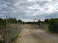
Connolly Drive's missing link between Kinross and Clarkson which opened August 2007.
Length 15 km (9 mi)
Direction North-South
From Shenton Avenue, Currambine
Major suburbs Kinross, Tamala Park, Clarkson, Merriwa, Ridgewood
To Benenden Avenue, Butler
Major junctions Moore Drive
Australian State Route 87.svg Burns Beach Road
Selkirk Drive
Neerabup Road
Hester Avenue
Lukin Drive

Connolly Drive is a minor arterial road in the outer northern suburbs of Perth, Western Australia. The road takes its name from the Perth suburb of Connolly, which lies just beyond the road's terminus.

The road extends northerly from Shenton Avenue in Currambine, west of Joondalup's central business district, to the outer suburb of Butler. Connolly Drive runs parallel with the busier Marmion Avenue and eases its traffic flow past the end of the Mitchell Freeway at Burns Beach Road.[1]

For the first 6 kilometres (3.7 mi) of its length, Connolly Drive is a dual carriageway. It reverts to a single-lane carriageway at Clarkson, at the roundabout with Neerabup Road. The speed limit varies at different points in its length, but never exceeds 70km/h.

Connolly Drive was exclusively a single-lane carriageway for many years until recent developments in 2007, 2010 and 2011 to upgrade the road in conjunction with the northern extension of the Mitchell Freeway. There are currently plans for Connolly Drive to be extended further north to the outer suburb of Yanchep, with the Joondalup railway line running through the median section of the road.

Intersections

A number of major intersections cross the road at various points. The most significant intersections are with Shenton Avenue, Burns Beach Road and Hester Avenue. [2]. Most are controlled by roundabouts, but the following junctions are controlled by traffic lights:

  • Shenton Avenue, Currambine
  • Selkirk Drive, Kinross
  • Lukin Drive, Butler

References

  1. ^ MAIN ROADS - Urban Projects - Mitchell Freeway.
  2. ^ UBD 2007 Perth and surrounds Street Directory 2007 - 49th Edition.

Gallery


Wikimedia Foundation. 2010.

Игры ⚽ Нужна курсовая?

Look at other dictionaries:

  • Connolly Drive, Perth — Infobox Australian Road | type = road road name = Connolly Drive route route route photo = ConnollyDriveMissingLink.jpg caption = Connolly Drive s missing link between Kinross and Clarkson which opened August 2007. length = 15 direction = North… …   Wikipedia

  • Connolly Apartment — (Сан Андрес,Колумбия) Категория отеля: Адрес: Avenida Providencia No 2a 89, 8800 …   Каталог отелей

  • Drive My Car — Song by The Beatles from the album Rubber Soul Released 3 December 1965 Recorded 13 October 1965, EMI Studios, London Genre Folk rock …   Wikipedia

  • Connolly, Western Australia — This article is about the suburb within Perth, Western Australia. For other uses, see Connolly (disambiguation). Connolly Perth, Western Australia …   Wikipedia

  • Billy Connolly's World Tour of Australia — infobox television| show name = Billy Connolly s World Tour of Australia caption = DVD box set cover rating = MA 15 format = Documentary / Comedy runtime = 320 minutes (40 min/episode) creator = Billy Connolly Nobby Clark Steve Brown starring =… …   Wikipedia

  • Joondalup Drive, Perth — Infobox Australian Road road name = Joondalup Drive route route route photo = caption = length = 13 direction = South North start = Edgewater finish = Banksia Grove est = 1990s through = Edgewater, Joondalup, Carramar, Tapping, Banksia Grove… …   Wikipedia

  • USS Connolly (DE-306) — Career Name: USS Connolly Laid down: 21 June 1943 …   Wikipedia

  • Hodges Drive, Perth — Infobox Australian Road road name = Hodges Drive route route route photo = caption = length = 3 direction = West east start = Ocean Reef Road, Ocean Reef finish = Joondalup Drive, Joondalup est = through = Connolly, Heathridge route = exits =… …   Wikipedia

  • Burns Beach Road, Perth — Infobox Australian Road road name = Burns Beach Road route route route photo = Burns Beach Road Railway.jpg caption = Burns Beach Road near Currambine Railway Station. length = 5 direction = East West start = Joondalup Drive, Joondalup finish =… …   Wikipedia

  • Merriwa, Western Australia — Coordinates: 31°39′58″S 115°43′05″E / 31.666°S 115.718°E / 31.666; 115.718 …   Wikipedia

Share the article and excerpts

Direct link
Do a right-click on the link above
and select “Copy Link”