- Rio Conchos
-
- This article is about the river in Mexico. For the river in the U.S. state of Texas, see Concho River. For the 1964 Western, see Rio Conchos (film).
Rio Conchos Río Conchos  Map of the Conchos
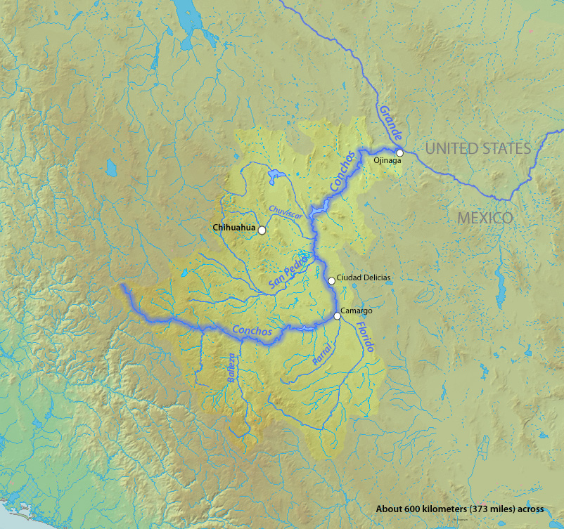
Country Mexico State Chihuahua (state) Source Sierra Madre Occidental - location Guadalupe, Chihuahua Mouth Rio Grande - location Ojinaga, Chihuahua - coordinates 29°35′N 104°25′W / 29.583°N 104.417°W [1] Length 560 km (348 mi) Basin 68,400 km2 (26,400 sq mi) [2] Discharge for IBWC station 08-3730.00, near Ojinaga - average 24 m3/s (848 cu ft/s) [3] - max 1,490 m3/s (52,619 cu ft/s) - min 0.09 m3/s (3 cu ft/s)  Map of the Rio Grande watershed, showing the Rio Conchos joining the Rio Grande near Ojinaga.
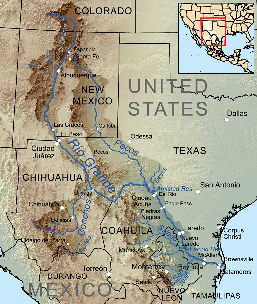
The Rio Conchos (Río Conchos) is a large river in the Mexican state of Chihuahua. It joins the Río Bravo del Norte (known in the United States as the Rio Grande) at the town of Ojinaga, Chihuahua.
Contents
Description
The Rio Conchos is the main river in the state of Chihuahua and the Rio Grande's largest tributary.[4] It is one of the most important river systems in all of northern Mexico.[2] The Conchos has several reservoirs that make use of its water for agricultural and hydropower uses.
Course
The Conchos rises in the Sierra Madre Occidental near Bocoyna in the municipality of Guadalupe, Chihuahua, where it heads east and receives several tributaries along the way. At Valle de Zaragoza (municipality), Chihuahua, it is stopped at the Presa de la Boquilla dam, the largest in Chihuahua forming Toronto Lake. It then heads east again forming Colina Lake and then passes through Camargo, Chihuahua, the main agricultural center in the region, where it receives the Florido as a tributary.
From there the Conchos heads north, receiving the San Pedro near Delicias, Chihuahua, entering the Chihuahua Desert and cutting a path through it, before turning to the northeast. At Aldama, Chihuahua, it is dammed by the Presa El Granero, then cuts through a canyon called the Peguis Canyon, before forming a last dam (Toribio Ortega) near Ojinaga. At Ojinaga it joins the Rio Bravo in English referred to as the (Rio Grande).
Ecology
The World Wide Fund for Nature (WWF) has included the Rio Conchos in its Global 200 Freshwater Ecoregions assessment. The Global 200 is a list of freshwater ecoregions (rivers systems and lakes, for example) that the WWF considers of global importance for biodiversity conservation. The WWF's assessment of the Rio Conchos rates its biological distinctiveness as "globally outstanding" and its conservation status as critically endangered, putting it in the "priority I" category of needing conservation attention.[5]
The Rio Conchos contains the only free-flowing large river environment left in the Rio Grande drainage basin. Its river and spring habitat ecosystems are relatively intact and support a highly endemic fish fauna. Twelve of its forty-seven native fish are endemic, as are twelve of its forty-six native herpetofauna species. The strong biodiversity has survived in part because the river's ecology has not been affected by channel modifications. The Rio Conchos region is significant not only for its surface water biota but also its and specialized spring and cave habitats, which contribute to the region's high endemism. However, conditions are being damaged by industrial pollution, sewage, agricultural wastes, flow regulation, exotic species, and overgrazing. Other threats include poor land and water management practices, such as clear-cutting along the upper Rio Conchos.[5]
See also
- List of rivers of Mexico
- List of longest rivers of Mexico
- List of tributaries of the Rio Grande
References
- ^ Rio Conchos at GEOnet Names Server
- ^ a b "The Rio Conchos: An Essential Ribbon of Life". Environmental Defense Fund. http://www.edf.org/article.cfm?contentID=2902. Retrieved 20 July 2010.
- ^ "Water Bulletin Number 75: Flow of the Rio Grande and Related Data; From Elephant Butte Dam, New Mexico to the Gulf of Mexico". International Boundary and Water Commission. 2005. http://www.ibwc.gov/Water_Data/water_bulletins.html. Retrieved 17 July 2010.
- ^ Benke, Arthur C.; Colbert E. Cushing (2005). Rivers of North America. Academic Press. pp. 186–192. ISBN 9780120882533. http://books.google.com/books?id=-bLMR552QBMC&pg=PA186.
- ^ a b Abell, Robin A.; David M. Olsen, Eric Dinerstein, Patrick T. Hurley et al. (2000). Freshwater Ecoregions of North America: A Conservation Assessment. Island Press. pp. 93, 103, 188–189. ISBN 9781559637343. http://books.google.com/books?id=IpDmnEWoA2oC&pg=PA93.
Categories:- Rio Conchos
- Tributaries of the Rio Grande
- Chihuahuan Desert
- Rivers of Sierra Madre Occidental
- Rivers of Mexico
- Geography of Chihuahua
- Mexican Plateau
Wikimedia Foundation. 2010.