Colón Island

Colón Island
Colón Island (Isla Colón)
Islands of Panama
Bocas del Toro Archipelago
Flag
Country Panama
State Bocas del Toro Province
District Bocas del Toro
Coordinates 9°23′15″N 82°15′30″W / 9.3875°N 82.25833°W / 9.3875; -82.25833
Capital Bocas del Toro
 - elevation 3 m (10 ft)
 - coordinates 9°20′0″N 82°15′0″W / 9.333333°N 82.25°W / 9.333333; -82.25
Lowest point Sea level
 - location Beaches
 - elevation 0 m (0 ft)
Timezone Eastern Standard Time (UTC-5)
 - summer (DST) No DST (UTC-5)
Location of Isla Colón in Panama

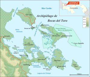
Colón Island (in Spanish: Isla Colón) is the northernmost and main island in the Bocas del Toro Archipelago located in Bocas del Toro Province, Panama. The capital city of the province, Bocas del Toro, is located on the island and is one of Panama's main tourist attractions. The city's airport is the centre of flights heading outside of the country and is a hub for Air Panama, the national carrier.

Beachfront hotels, restaurants, night clubs, discothèques and residential districts are prominent on Colón Island, which has one of Panama's biggest ports. The island has a strong boating community. Access to the other nearby islands in the archipelago requires either a private boat, or the rental of a water taxi.

See also

References


Wikimedia Foundation. 2010.

Игры ⚽ Поможем сделать НИР

Look at other dictionaries:

  • Colón, Panama — This article is about the city in Panama. For the province, see Colón Province. Colón …   Wikipedia

  • colon — colon1 /koh leuhn/, n., pl. colons for 1, cola / leuh/ for 2. 1. the sign (:) used to mark a major division in a sentence, to indicate that what follows is an elaboration, summation, implication, etc., of what precedes; or to separate groups of… …   Universalium

  • Colón — /koh lon /; Sp. /kaw lawn /, n. a seaport in Panama at the Atlantic end of the Panama Canal. 85,600. * * * Segment that makes up most of the large intestine. Though the two terms are often used interchangeably, the colon technically excludes the… …   Universalium

  • Cristóbal Island — Native name: Isla San Cristóbal Bocas del Toro Archipelago Geography Coordinates …   Wikipedia

  • Bocas del Toro "Isla Colon" International Airport — Infobox Airport name = Bocas del Toro Isla Colon International Airport nativename = Aeropuerto Internacional de Bocas del Toro Isla Colon IATA = BOC ICAO = MPBO type = Public owner = operator = [http://www.aeronautica.gob.pa/ Autoridad… …   Wikipedia

  • Cristóbal, Colón — Cristobal, CZ in March 1933 …   Wikipedia

  • Ramiro L. Colon — (1904 ndash;1983), is credited with having saved the coffee industry in Puerto Rico.Early yearsColon (birth name: Ramiro L. Colon Castano), was born in and raised in the countryside of Ponce, Puerto Rico. There he received his primary and… …   Wikipedia

  • Rafael Hernández Colón — Infobox Governor name= Rafael Hernández Colón caption= order=4th office= Governor of the Commonwealth of Puerto Rico term start= January 2, 1973 term end=January 2, 1977 term start=January 2, 1985 term end=January 2, 1993 lieutenant= predecessor …   Wikipedia

  • Cebu (island) — Infobox Islands name = Cebu image caption = Map of the Philippines showing Cebu locator Location map|Philippines|lat=10.522919|long=123.84613|width=175|float=center map custom = yes native name = Sugbo native name link = Cebuano language location …   Wikipedia

  • Centro Colon Hotel San Jose (San Jose (CR)) — Centro Colon Hotel San Jose country: Costa Rica, city: San Jose (CR) (City Centre) Centro Colon Hotel San Jose Situated just 15 minutes from the international airport, Centro Colon Hotel San Jose is next to the shopping and business centre.… …   International hotels

Share the article and excerpts

Direct link
Do a right-click on the link above
and select “Copy Link”